Property Record
625 N Bridgeport Ter, Lindenhurst, IL 60046
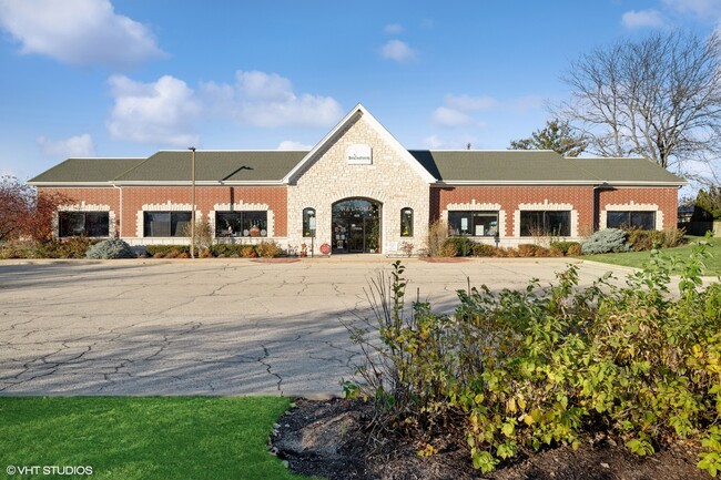
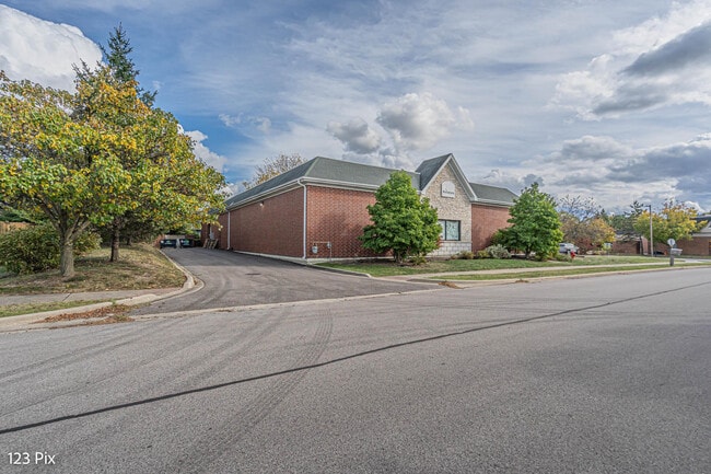
This Property Is For Sale
NEARBY LISTINGS FOR SALE OR LEASE
Property Detail
625 N Bridgeport Ter
Chicago-Naperville-Elgin, IL-IN-WI
Bridgeport Terrace Resub
02-25-306-063
BRIDGEPORT TERRACE RESUB; LT4 (EX OFFICE BLDG 1)
Commercialbuilding
Lake
X
Illinois
17097C0042L
4
2023
0.23 AC
2024
Far North
861013
Chicago
9,128 SF
DEMOGRAPHICS near 625 N Bridgeport Ter
1 Mile
3 Mile
5 Mile
2024 Total Population
4,377
26,711
74,772
2029 Population
4,294
26,475
73,759
Pop Growth 2024-2029
(1.90%)
(0.88%)
(1.35%)
Average Age
39
40
39
2024 Total Households
1,435
9,446
25,990
HH Growth 2024-2029
(2.02%)
(1.03%)
(1.47%)
Median Household Inc
$125,784
$116,087
$112,452
Avg Household Size
3.00
2.80
2.80
2024 Avg HH Vehicles
2.00
2.00
2.00
Median Home Value
$257,744
$260,460
$260,057
Median Year Built
1984
1989
1991
Nearby Places
Map Layers
Map Styles
 Street
 Aerial
- Restaurants
- Banks
- Shops
- Fitness
- Groceries
PUBLIC TRANSPORTATION
COMMUTER RAIL
Lake Villa Station (North Central Service - Northeast Illinois Regional Commuter Railroad (Metra))
DRIVE
WALK
Distance
Lake Villa Station (North Central Service - Northeast Illinois Regional Commuter Railroad (Metra))
12 min
4.8 mi
Round Lake Beach Station (North Central Service - Northeast Illinois Regional Commuter Railroad (Metra))
DRIVE
WALK
Distance
Round Lake Beach Station (North Central Service - Northeast Illinois Regional Commuter Railroad (Metra))
14 min
7.3 mi
Freight Ports
Port Milwaukee
DRIVE
WALK
Distance
Port Milwaukee
59 min
46.4 mi
Nearby Properties
Address
Land Use
TOTAL SIZE
Lot Size
Zoning
Address
Land Use
TOTAL SIZE
Lot Size
Zoning
558,250 SF
25.28 AC
Address
Land Use
TOTAL SIZE
Lot Size
Zoning
454,000 SF
23.60 AC
Address
Land Use
TOTAL SIZE
Lot Size
Zoning
5,303,058 SF
26.82 AC
Address
Land Use
TOTAL SIZE
Lot Size
Zoning
2,415,756 SF
12.61 AC
Address
Land Use
TOTAL SIZE
Lot Size
Zoning
161,950 SF
16.83 AC
Address
Land Use
TOTAL SIZE
Lot Size
Zoning
854,280 SF
18.40 AC
Address
Land Use
TOTAL SIZE
Lot Size
Zoning
2,444,464 SF
5.14 AC
Address
Land Use
TOTAL SIZE
Lot Size
Zoning
Address
Land Use
TOTAL SIZE
Lot Size
Zoning
129,483 SF
15.64 AC
Address
Land Use
TOTAL SIZE
Lot Size
Zoning
46,068 SF
0.65 AC
Address
Land Use
TOTAL SIZE
Lot Size
Zoning
50,540 SF
1.54 AC
Address
Land Use
TOTAL SIZE
Lot Size
Zoning
57,398 SF
5.23 AC
Address
Land Use
TOTAL SIZE
Lot Size
Zoning
58,442 SF
3.70 AC
Address
Land Use
TOTAL SIZE
Lot Size
Zoning
333,536 SF
2.67 AC
Address
Land Use
TOTAL SIZE
Lot Size
Zoning
3.53 AC
Address
Land Use
TOTAL SIZE
Lot Size
Zoning
243,024 SF
2.17 AC
Address
Land Use
TOTAL SIZE
Lot Size
Zoning
18.94 AC
Address
Land Use
TOTAL SIZE
Lot Size
Zoning
63,643 SF
9.12 AC
Address
Land Use
TOTAL SIZE
Lot Size
Zoning
41,161 SF
608.77 AC
Address
Land Use
TOTAL SIZE
Lot Size
Zoning
23,400 SF
2.69 AC
Address
Land Use
TOTAL SIZE
Lot Size
Zoning
11,924 SF
3.97 AC
Address
Land Use
TOTAL SIZE
Lot Size
Zoning
14,418 SF
1.50 AC
Address
Land Use
TOTAL SIZE
Lot Size
Zoning
68,264 SF
1.30 AC
Address
Land Use
TOTAL SIZE
Lot Size
Zoning
22,200 SF
1.80 AC
Address
Land Use
TOTAL SIZE
Lot Size
Zoning
19,552 SF
1.87 AC
Address
Land Use
TOTAL SIZE
Lot Size
Zoning
28,220 SF
1.36 AC
Address
Land Use
TOTAL SIZE
Lot Size
Zoning
18,201 SF
1.75 AC
Address
Land Use
TOTAL SIZE
Lot Size
Zoning
254,961 SF
2.86 AC
Address
Land Use
TOTAL SIZE
Lot Size
Zoning
25,600 SF
2.51 AC
Address
Land Use
TOTAL SIZE
Lot Size
Zoning
16,270 SF
3.08 AC
The World's #1 Commercial Real Estate Marketplace
Connect with us
© 2025 CoStar Group
The information above has been obtained from sources believed reliable. While we do not doubt its accuracy we have not verified it and make no guarantee, warranty or representation about it. It is your responsibility to independently confirm its accuracy and completeness. Any projections, opinions, assumptions, or estimates used are for example only and do not represent the current or future performance of the property. The value of this transaction to you depends on tax and other factors which should be evaluated by your tax, financial, and legal advisors. You and your advisors should conduct a careful, independent investigation of the property to determine to your satisfaction the suitability of the property for your needs.