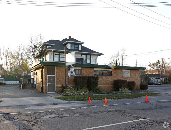
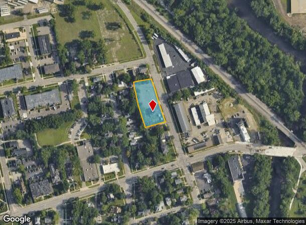
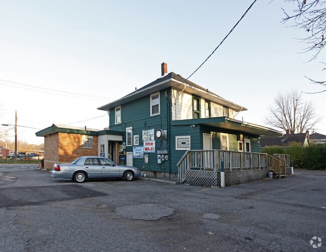
Property Record
625 N Huron St, Ypsilanti, MI 48197
NEARBY LISTINGS FOR SALE OR LEASE
Property Detail
625 N Huron St
Ann Arbor, MI
Of Scovill And Tuttle Subdivision
11-04-361-021
ASSR REQUEST ****FROM 1104361015 02/23/95****FROM 1104361016 02/23/95****FROM 1104361017 02/23/95YP CITY 1-W329A BEG AT PT ON W LINE HURONST ST 230.00 FT N OF N LINE FOREST AVE, TH W PARALLEL N LN FOREST AVE 120.00 FT, TH TH NPARALLEL W LN HURON ST.
Commercialnec
Washtenaw
X
Michigan
26161C0426E
4-5
2025
0.73 AC
2025
Washtenaw E of 23
411000
Detroit
1,562 SF
DEMOGRAPHICS near 625 N Huron St
1 Mile
3 Mile
5 Mile
2024 Total Population
15,081
66,527
123,396
2029 Population
14,969
65,801
121,985
Pop Growth 2024-2029
(0.74%)
(1.09%)
(1.14%)
Average Age
33
37
38
2024 Total Households
6,535
28,613
51,752
HH Growth 2024-2029
(0.99%)
(1.27%)
(1.29%)
Median Household Inc
$44,378
$49,297
$59,649
Avg Household Size
2.00
2.20
2.20
2024 Avg HH Vehicles
1.00
2.00
2.00
Median Home Value
$186,919
$171,214
$223,047
Median Year Built
1956
1969
1975
Nearby Places
Map Layers
Map Styles
 Street
 Aerial
- Restaurants
- Banks
- Shops
- Fitness
- Groceries
PUBLIC TRANSPORTATION
COMMUTER RAIL
DRIVE
WALK
Distance
17 min
8.0 mi
AIRPORT
Detroit Metro Wayne County
DRIVE
WALK
Distance
Detroit Metro Wayne County
30 min
20.3 mi
Windsor International
DRIVE
WALK
Distance
Windsor International
67 min
45.8 mi
Freight Ports
DRIVE
WALK
Distance
75 min
60.1 mi
Nearby Properties
Address
Land Use
TOTAL SIZE
Lot Size
Zoning
Address
Land Use
TOTAL SIZE
Lot Size
Zoning
169,963 SF
86.24 AC
P-M
Address
Land Use
TOTAL SIZE
Lot Size
Zoning
36,000 SF
27.61 AC
BI
Address
Land Use
TOTAL SIZE
Lot Size
Zoning
37,500 SF
25.94 AC
BI
Address
Land Use
TOTAL SIZE
Lot Size
Zoning
118,166 SF
P-M
Address
Land Use
TOTAL SIZE
Lot Size
Zoning
361,634 SF
17.09 AC
Address
Land Use
TOTAL SIZE
Lot Size
Zoning
13,720 SF
37.87 AC
Address
Land Use
TOTAL SIZE
Lot Size
Zoning
480 SF
23.64 AC
BI
Address
Land Use
TOTAL SIZE
Lot Size
Zoning
27,306 SF
16.08 AC
BI
Address
Land Use
TOTAL SIZE
Lot Size
Zoning
16,472 SF
29 AC
Address
Land Use
TOTAL SIZE
Lot Size
Zoning
30.77 AC
P-C
Address
Land Use
TOTAL SIZE
Lot Size
Zoning
168,450 SF
8.47 AC
Address
Land Use
TOTAL SIZE
Lot Size
Zoning
1,344 SF
18.17 AC
SPLIT
Address
Land Use
TOTAL SIZE
Lot Size
Zoning
26,146 SF
7.35 AC
BI
Address
Land Use
TOTAL SIZE
Lot Size
Zoning
11,204 SF
28 AC
Address
Land Use
TOTAL SIZE
Lot Size
Zoning
27,060 SF
11.47 AC
SPLIT
Address
Land Use
TOTAL SIZE
Lot Size
Zoning
27,060 SF
5.53 AC
SPLIT
Address
Land Use
TOTAL SIZE
Lot Size
Zoning
12,747 SF
22.86 AC
BA
Address
Land Use
TOTAL SIZE
Lot Size
Zoning
19,692 SF
21.22 AC
BA
Address
Land Use
TOTAL SIZE
Lot Size
Zoning
6,192 SF
19.02 AC
BA
Address
Land Use
TOTAL SIZE
Lot Size
Zoning
32,974 SF
29.96 AC
BA
Address
Land Use
TOTAL SIZE
Lot Size
Zoning
11,630 SF
17.36 AC
BA
Address
Land Use
TOTAL SIZE
Lot Size
Zoning
259,778 SF
25.39 AC
Address
Land Use
TOTAL SIZE
Lot Size
Zoning
26,550 SF
5.44 AC
MD
Address
Land Use
TOTAL SIZE
Lot Size
Zoning
15,877 SF
60 AC
Address
Land Use
TOTAL SIZE
Lot Size
Zoning
81,279 SF
24.86 AC
PUD
Address
Land Use
TOTAL SIZE
Lot Size
Zoning
960 SF
15 AC
BA
Address
Land Use
TOTAL SIZE
Lot Size
Zoning
48,756 SF
5 AC
CN
Address
Land Use
TOTAL SIZE
Lot Size
Zoning
12,747 SF
17.90 AC
BA
Address
Land Use
TOTAL SIZE
Lot Size
Zoning
29,502 SF
11.29 AC
BA
Address
Land Use
TOTAL SIZE
Lot Size
Zoning
124,513 SF
3.79 AC
GC
The World's #1 Commercial Real Estate Marketplace
Connect with us
© 2025 CoStar Group
The information above has been obtained from sources believed reliable. While we do not doubt its accuracy we have not verified it and make no guarantee, warranty or representation about it. It is your responsibility to independently confirm its accuracy and completeness. Any projections, opinions, assumptions, or estimates used are for example only and do not represent the current or future performance of the property. The value of this transaction to you depends on tax and other factors which should be evaluated by your tax, financial, and legal advisors. You and your advisors should conduct a careful, independent investigation of the property to determine to your satisfaction the suitability of the property for your needs.