Property Record
625 W Hurst Blvd, Hurst, TX 76053
NEARBY LISTINGS FOR SALE OR LEASE
-
-
-
-
-
-
-
No Photo
-
View all Hurst listings for sale on LoopNet.com
Property Detail
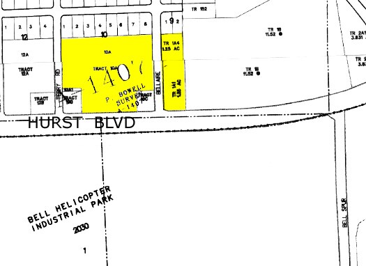
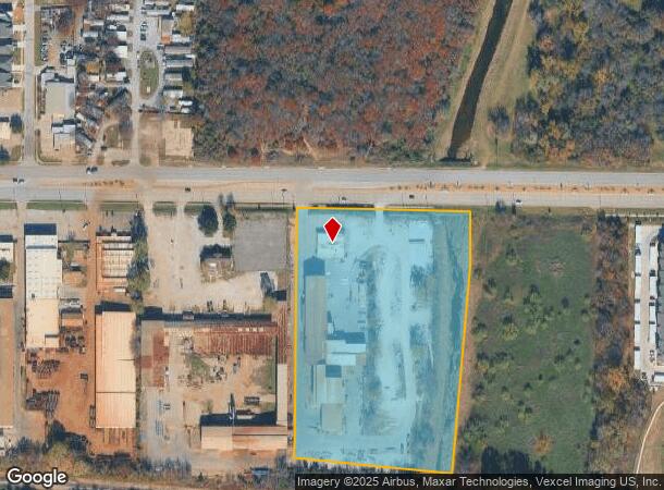
625 W Hurst Blvd
00252611
Boyles, Addition
Industrialgeneral
BOYLES, ADDITION TRACT A & A1626 TR 2A3
AE
Tarrant
48439C0220L
Texas
2024
9.25 AC
2025
HEB/Mid-Cities
113408
Dallas/Ft Worth
36,508 SF
Dallas-Fort Worth-Arlington, TX
DEMOGRAPHICS near 625 W Hurst Blvd
1 Mile
3 Mile
5 Mile
2024 Total Population
12,644
83,913
265,653
2029 Population
13,454
88,452
280,690
Pop Growth 2024-2029
+ 6.41%
+ 5.41%
+ 5.66%
Average Age
35
38
39
2024 Total Households
4,516
32,966
106,751
HH Growth 2024-2029
+ 6.47%
+ 5.45%
+ 5.74%
Median Household Inc
$61,114
$65,451
$69,004
Avg Household Size
2.70
2.50
2.40
2024 Avg HH Vehicles
2.00
2.00
2.00
Median Home Value
$248,564
$258,255
$275,860
Median Year Built
1972
1978
1982
Nearby Places
Map Layers
Map Styles
 Street
 Aerial
- Restaurants
- Banks
- Shops
- Fitness
- Groceries
PUBLIC TRANSPORTATION
COMMUTER RAIL
Hurst/Bell (TRINITY RAILWAY - Dallas Area Rapid Transit (DART), Trinity Railway Express - Dallas Area Rapid Transit (DART))
DRIVE
WALK
Distance
Hurst/Bell (TRINITY RAILWAY - Dallas Area Rapid Transit (DART), Trinity Railway Express - Dallas Area Rapid Transit (DART))
4 min
1.7 mi
Trinity Lakes Station (TRINITY RAILWAY - Dallas Area Rapid Transit (DART))
DRIVE
WALK
Distance
Trinity Lakes Station (TRINITY RAILWAY - Dallas Area Rapid Transit (DART))
6 min
2.5 mi
AIRPORT
Dallas-Fort Worth International
DRIVE
WALK
Distance
Dallas-Fort Worth International
22 min
13.6 mi
Dallas Love Field
DRIVE
WALK
Distance
Dallas Love Field
33 min
22.3 mi
Freight Ports
Port of Shreveport
DRIVE
WALK
Distance
Port of Shreveport
243 min
221.5 mi
Nearby Properties
Address
Land Use
TOTAL SIZE
Lot Size
Zoning
Address
Land Use
TOTAL SIZE
Lot Size
Zoning
1,300,314 SF
40.15 AC
Address
Land Use
TOTAL SIZE
Lot Size
Zoning
356,000 SF
39.44 AC
Address
Land Use
TOTAL SIZE
Lot Size
Zoning
521,150 SF
92.05 AC
Address
Land Use
TOTAL SIZE
Lot Size
Zoning
1,544,748 SF
76.25 AC
Address
Land Use
TOTAL SIZE
Lot Size
Zoning
174,596 SF
11.91 AC
Address
Land Use
TOTAL SIZE
Lot Size
Zoning
231,871 SF
17.08 AC
Address
Land Use
TOTAL SIZE
Lot Size
Zoning
260,590 SF
15.30 AC
Address
Land Use
TOTAL SIZE
Lot Size
Zoning
318,602 SF
9.90 AC
Address
Land Use
TOTAL SIZE
Lot Size
Zoning
348,941 SF
22.25 AC
Address
Land Use
TOTAL SIZE
Lot Size
Zoning
237,551 SF
4.39 AC
Address
Land Use
TOTAL SIZE
Lot Size
Zoning
173,068 SF
15.55 AC
Address
Land Use
TOTAL SIZE
Lot Size
Zoning
232,295 SF
21.49 AC
Address
Land Use
TOTAL SIZE
Lot Size
Zoning
235,530 SF
13.21 AC
Address
Land Use
TOTAL SIZE
Lot Size
Zoning
194,625 SF
15.07 AC
Address
Land Use
TOTAL SIZE
Lot Size
Zoning
221,591 SF
14.50 AC
Address
Land Use
TOTAL SIZE
Lot Size
Zoning
220,650 SF
3.03 AC
Address
Land Use
TOTAL SIZE
Lot Size
Zoning
445,900 SF
29.07 AC
Address
Land Use
TOTAL SIZE
Lot Size
Zoning
526,195 SF
40.84 AC
Address
Land Use
TOTAL SIZE
Lot Size
Zoning
262,233 SF
16.13 AC
Address
Land Use
TOTAL SIZE
Lot Size
Zoning
192,482 SF
9.77 AC
Address
Land Use
TOTAL SIZE
Lot Size
Zoning
199,744 SF
9.99 AC
Address
Land Use
TOTAL SIZE
Lot Size
Zoning
191,235 SF
10.93 AC
Address
Land Use
TOTAL SIZE
Lot Size
Zoning
146,918 SF
3.31 AC
Address
Land Use
TOTAL SIZE
Lot Size
Zoning
270,576 SF
16.34 AC
Address
Land Use
TOTAL SIZE
Lot Size
Zoning
403,363 SF
24.03 AC
Address
Land Use
TOTAL SIZE
Lot Size
Zoning
139,440 SF
5.97 AC
Address
Land Use
TOTAL SIZE
Lot Size
Zoning
181,988 SF
8.10 AC
Address
Land Use
TOTAL SIZE
Lot Size
Zoning
109,491 SF
10.01 AC
Address
Land Use
TOTAL SIZE
Lot Size
Zoning
162,898 SF
8.68 AC
Address
Land Use
TOTAL SIZE
Lot Size
Zoning
123,801 SF
10.44 AC
The World's #1 Commercial Real Estate Marketplace
Connect with us
© 2026 CoStar Group
The information above has been obtained from sources believed reliable. While we do not doubt its accuracy we have not verified it and make no guarantee, warranty or representation about it. It is your responsibility to independently confirm its accuracy and completeness. Any projections, opinions, assumptions, or estimates used are for example only and do not represent the current or future performance of the property. The value of this transaction to you depends on tax and other factors which should be evaluated by your tax, financial, and legal advisors. You and your advisors should conduct a careful, independent investigation of the property to determine to your satisfaction the suitability of the property for your needs.