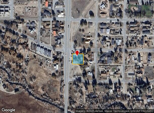
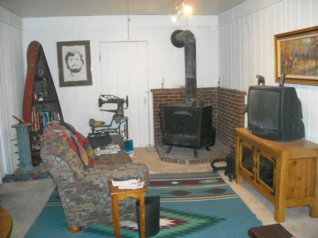
Property Record
6250 Us Highway 285, Poncha Springs, CO 81242

NEARBY LISTINGS FOR SALE OR LEASE
-
-
View all Poncha Springs listings for sale on LoopNet.com
Property Detail
6250 Us Highway 285
Other Market Areas
Poncha Spgs
R380510309154
Chaffee
Sfr
Colorado
X
0.30 AC
08015C0589D
Colorado Southwest Area
3,076 SF
DEMOGRAPHICS near 6250 Us Highway 285
1 Mile
3 Mile
5 Mile
2024 Total Population
862
1,621
8,545
2029 Population
932
1,758
9,357
Pop Growth 2024-2029
+ 8.12%
+ 8.45%
+ 9.50%
Average Age
46
46
46
2024 Total Households
401
750
3,997
HH Growth 2024-2029
+ 8.48%
+ 8.93%
+ 9.93%
Median Household Inc
$76,807
$76,661
$69,749
Avg Household Size
2.10
2.20
2.10
2024 Avg HH Vehicles
2.00
2.00
2.00
Median Home Value
$687,500
$674,274
$525,884
Median Year Built
1997
1997
1993
Nearby Places
Map Layers
Map Styles
 Street
 Aerial
- Restaurants
- Banks
- Shops
- Fitness
- Groceries
SALE & LEASE HISTORY
LISTING DATE
SALE/LEASE

Sep 24, 2016
For Sale
Nearby Properties
Address
Land Use
TOTAL SIZE
Lot Size
Zoning
Address
Land Use
TOTAL SIZE
Lot Size
Zoning
32,100 SF
3.73 AC
Address
Land Use
TOTAL SIZE
Lot Size
Zoning
21,700 SF
20 AC
Address
Land Use
TOTAL SIZE
Lot Size
Zoning
55,512 SF
4.19 AC
Address
Land Use
TOTAL SIZE
Lot Size
Zoning
35,395 SF
2.96 AC
Address
Land Use
TOTAL SIZE
Lot Size
Zoning
9,660 SF
70.58 AC
Address
Land Use
TOTAL SIZE
Lot Size
Zoning
54,950 SF
4.15 AC
Address
Land Use
TOTAL SIZE
Lot Size
Zoning
120 SF
59.52 AC
Address
Land Use
TOTAL SIZE
Lot Size
Zoning
3,915 SF
172.40 AC
Address
Land Use
TOTAL SIZE
Lot Size
Zoning
44,600 SF
10.36 AC
Address
Land Use
TOTAL SIZE
Lot Size
Zoning
8,000 SF
0.56 AC
Address
Land Use
TOTAL SIZE
Lot Size
Zoning
35,500 SF
6.47 AC
Address
Land Use
TOTAL SIZE
Lot Size
Zoning
31,200 SF
1.74 AC
Address
Land Use
TOTAL SIZE
Lot Size
Zoning
26,080 SF
1.91 AC
Address
Land Use
TOTAL SIZE
Lot Size
Zoning
10,572 SF
2.36 AC
Address
Land Use
TOTAL SIZE
Lot Size
Zoning
19,520 SF
16.02 AC
Address
Land Use
TOTAL SIZE
Lot Size
Zoning
9,081 SF
7.84 AC
Address
Land Use
TOTAL SIZE
Lot Size
Zoning
17,060 SF
3.27 AC
Address
Land Use
TOTAL SIZE
Lot Size
Zoning
15,000 SF
2.07 AC
Address
Land Use
TOTAL SIZE
Lot Size
Zoning
8,848 SF
3.35 AC
Address
Land Use
TOTAL SIZE
Lot Size
Zoning
24,000 SF
3.36 AC
Address
Land Use
TOTAL SIZE
Lot Size
Zoning
12,400 SF
2.60 AC
Address
Land Use
TOTAL SIZE
Lot Size
Zoning
3,484 SF
185 AC
Address
Land Use
TOTAL SIZE
Lot Size
Zoning
13,102 SF
1.42 AC
Address
Land Use
TOTAL SIZE
Lot Size
Zoning
1,107 SF
0.89 AC
Address
Land Use
TOTAL SIZE
Lot Size
Zoning
21,104 SF
1.15 AC
Address
Land Use
TOTAL SIZE
Lot Size
Zoning
3,870 SF
0.97 AC
Address
Land Use
TOTAL SIZE
Lot Size
Zoning
9.50 AC
Address
Land Use
TOTAL SIZE
Lot Size
Zoning
4,800 SF
3.65 AC
Address
Land Use
TOTAL SIZE
Lot Size
Zoning
8,154 SF
2.30 AC
Address
Land Use
TOTAL SIZE
Lot Size
Zoning
5,216 SF
6.60 AC
The World's #1 Commercial Real Estate Marketplace
Connect with us
© 2026 CoStar Group
The information above has been obtained from sources believed reliable. While we do not doubt its accuracy we have not verified it and make no guarantee, warranty or representation about it. It is your responsibility to independently confirm its accuracy and completeness. Any projections, opinions, assumptions, or estimates used are for example only and do not represent the current or future performance of the property. The value of this transaction to you depends on tax and other factors which should be evaluated by your tax, financial, and legal advisors. You and your advisors should conduct a careful, independent investigation of the property to determine to your satisfaction the suitability of the property for your needs.