Property Record
6251 State Route 251, Peru, IL 61354
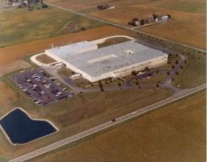

Property Detail
6251 State Route 251
11-32-202000
PT NE NE SEC 32-34-1; BEG NE COR NE NE, S1322.96', W1318.15', NE183.22' N1139.98', E1309' TO POB (EX PT TO RD2025-10227
Industrialgeneral
La Salle
B and X Area of moderate flood hazard, usually the area between the limits of the 100-year and 500-year floods.
Illinois
2024
37.93 AC
2025
I-39 Cor/LaSalle Cnty
963200
Chicago
24,960 SF
Ottawa, IL
NEARBY LISTINGS FOR SALE OR LEASE
-
-
View all Peru listings for sale on LoopNet.com
DEMOGRAPHICS near 6251 State Route 251
1 mile
3 mile
5 mile
2025 Total Population
101
6,698
23,011
2030 Population
99
6,610
22,807
Pop Growth 2025-2030
(1.98%)
(1.31%)
(0.89%)
Average Age
44
46
43
2025 Total Households
37
2,898
9,984
HH Growth 2025-2030
(2.70%)
(1.28%)
(0.87%)
Median Household Inc
$118,749
$61,667
$63,228
Avg Household Size
2.80
2.20
2.20
2025 Avg HH Vehicles
2.00
2.00
2.00
Median Home Value
$295,832
$177,371
$154,485
Median Year Built
1977
1972
1958
Nearby Places
Map Layers
Map Styles
 Street
 Aerial
Layers
 Traffic
 Biking
Places
Listings with unknown addresses are not visible on the map
- Restaurants
- Banks
- Shops
- Fitness
- Groceries
Nearby Properties
Address
Land Use
TOTAL SIZE
Lot Size
Zoning
Address
Land Use
TOTAL SIZE
Lot Size
Zoning
70,080 SF
15.72 AC
Address
Land Use
TOTAL SIZE
Lot Size
Zoning
221,701 SF
20.73 AC
Address
Land Use
TOTAL SIZE
Lot Size
Zoning
10,494 SF
26.28 AC
Address
Land Use
TOTAL SIZE
Lot Size
Zoning
100 SF
40.13 AC
Address
Land Use
TOTAL SIZE
Lot Size
Zoning
2,880 SF
15.38 AC
Address
Land Use
TOTAL SIZE
Lot Size
Zoning
200 SF
32.64 AC
Address
Land Use
TOTAL SIZE
Lot Size
Zoning
310,664 SF
39.69 AC
Address
Land Use
TOTAL SIZE
Lot Size
Zoning
11,591 SF
0.35 AC
Address
Land Use
TOTAL SIZE
Lot Size
Zoning
63,936 SF
4.03 AC
Address
Land Use
TOTAL SIZE
Lot Size
Zoning
76,435 SF
10.59 AC
Address
Land Use
TOTAL SIZE
Lot Size
Zoning
167,300 SF
12.18 AC
Address
Land Use
TOTAL SIZE
Lot Size
Zoning
44,798 SF
3.06 AC
Address
Land Use
TOTAL SIZE
Lot Size
Zoning
55,917 SF
16.95 AC
Address
Land Use
TOTAL SIZE
Lot Size
Zoning
62,409 SF
10.81 AC
Address
Land Use
TOTAL SIZE
Lot Size
Zoning
15,100 SF
1.70 AC
Address
Land Use
TOTAL SIZE
Lot Size
Zoning
108,446 SF
10.59 AC
Address
Land Use
TOTAL SIZE
Lot Size
Zoning
15,035 SF
7.39 AC
Address
Land Use
TOTAL SIZE
Lot Size
Zoning
11,192 SF
16.23 AC
Address
Land Use
TOTAL SIZE
Lot Size
Zoning
56,960 SF
7.13 AC
Address
Land Use
TOTAL SIZE
Lot Size
Zoning
7,040 SF
1.44 AC
Address
Land Use
TOTAL SIZE
Lot Size
Zoning
32,436 SF
14.40 AC
Address
Land Use
TOTAL SIZE
Lot Size
Zoning
103,248 SF
8.74 AC
Address
Land Use
TOTAL SIZE
Lot Size
Zoning
81,179 SF
7.47 AC
Address
Land Use
TOTAL SIZE
Lot Size
Zoning
7,556 SF
3.70 AC
Address
Land Use
TOTAL SIZE
Lot Size
Zoning
223,643 SF
33.87 AC
Address
Land Use
TOTAL SIZE
Lot Size
Zoning
4,704 SF
9.08 AC
Address
Land Use
TOTAL SIZE
Lot Size
Zoning
2,100 SF
3.97 AC
Address
Land Use
TOTAL SIZE
Lot Size
Zoning
80,014 SF
20 AC
The World's #1 Commercial Real Estate Marketplace
Connect with us
© 2026 CoStar Group
The information above has been obtained from sources believed reliable. While we do not doubt its accuracy we have not verified it and make no guarantee, warranty or representation about it. It is your responsibility to independently confirm its accuracy and completeness. Any projections, opinions, assumptions, or estimates used are for example only and do not represent the current or future performance of the property. The value of this transaction to you depends on tax and other factors which should be evaluated by your tax, financial, and legal advisors. You and your advisors should conduct a careful, independent investigation of the property to determine to your satisfaction the suitability of the property for your needs.