Property Record
6255 S Valley Pike, Mount Crawford, VA 22841


NEARBY LISTINGS FOR SALE OR LEASE
-
-
View all Mount Crawford listings for lease on LoopNet.com
Property Detail
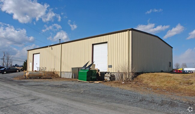
6255 S Valley Pike
137-A-L8H
Nr Valley Pike
Officebuilding
NR VALLEY PIKE
X
Rockingham
51165C0531D
Virginia
2025
3 AC
2025
Staunton & Harrisonburg
011600
Other Market Areas
8,000 SF
Harrisonburg, VA
DEMOGRAPHICS near 6255 S Valley Pike
1 Mile
3 Mile
5 Mile
2024 Total Population
505
9,715
27,182
2029 Population
518
10,104
27,900
Pop Growth 2024-2029
+ 2.57%
+ 4.00%
+ 2.64%
Average Age
43
40
38
2024 Total Households
180
3,274
9,939
HH Growth 2024-2029
+ 2.78%
+ 4.25%
+ 2.64%
Median Household Inc
$101,704
$74,021
$70,202
Avg Household Size
2.70
2.40
2.50
2024 Avg HH Vehicles
2.00
2.00
2.00
Median Home Value
$299,999
$316,052
$293,118
Median Year Built
1991
1986
1992
Nearby Places
Map Layers
Map Styles
 Street
 Aerial
- Restaurants
- Banks
- Shops
- Fitness
- Groceries
SALE & LEASE HISTORY
LISTING DATE
SALE/LEASE

Mar 27, 2017
For Lease
Nearby Properties
Address
Land Use
TOTAL SIZE
Lot Size
Zoning
Address
Land Use
TOTAL SIZE
Lot Size
Zoning
25,038 SF
56.59 AC
R1
Address
Land Use
TOTAL SIZE
Lot Size
Zoning
57.92 AC
I1
Address
Land Use
TOTAL SIZE
Lot Size
Zoning
199.08 AC
I1
Address
Land Use
TOTAL SIZE
Lot Size
Zoning
260,792 SF
27.98 AC
P1
Address
Land Use
TOTAL SIZE
Lot Size
Zoning
225,359 SF
33.32 AC
I1
Address
Land Use
TOTAL SIZE
Lot Size
Zoning
4,841 SF
7.07 AC
R3
Address
Land Use
TOTAL SIZE
Lot Size
Zoning
18,536 SF
114.50 AC
S1
Address
Land Use
TOTAL SIZE
Lot Size
Zoning
7,463 SF
74.63 AC
I1
Address
Land Use
TOTAL SIZE
Lot Size
Zoning
16.52 AC
TOWN
Address
Land Use
TOTAL SIZE
Lot Size
Zoning
295,543 SF
33.23 AC
I1
Address
Land Use
TOTAL SIZE
Lot Size
Zoning
905,215 SF
26.54 AC
M1
Address
Land Use
TOTAL SIZE
Lot Size
Zoning
348,800 SF
26.90 AC
I1
Address
Land Use
TOTAL SIZE
Lot Size
Zoning
21.42 AC
I1
Address
Land Use
TOTAL SIZE
Lot Size
Zoning
15.50 AC
GENERAL IN
Address
Land Use
TOTAL SIZE
Lot Size
Zoning
74,032 SF
20.64 AC
R3
Address
Land Use
TOTAL SIZE
Lot Size
Zoning
172,510 SF
12.96 AC
GENERAL IN
Address
Land Use
TOTAL SIZE
Lot Size
Zoning
216,800 SF
19.20 AC
I1
Address
Land Use
TOTAL SIZE
Lot Size
Zoning
36,612 SF
12.78 AC
R3
Address
Land Use
TOTAL SIZE
Lot Size
Zoning
47,160 SF
5.94 AC
GENERAL IN
Address
Land Use
TOTAL SIZE
Lot Size
Zoning
44,350 SF
10 AC
GENERAL IN
Address
Land Use
TOTAL SIZE
Lot Size
Zoning
28,160 SF
2.57 AC
GENERAL BU
Address
Land Use
TOTAL SIZE
Lot Size
Zoning
57,080 SF
1.98 AC
GENERAL BU
Address
Land Use
TOTAL SIZE
Lot Size
Zoning
8,288 SF
8.97 AC
GENERAL BU
Address
Land Use
TOTAL SIZE
Lot Size
Zoning
81,321 SF
13.84 AC
GENERAL IN
Address
Land Use
TOTAL SIZE
Lot Size
Zoning
37,186 SF
1.48 AC
GENERAL BU
Address
Land Use
TOTAL SIZE
Lot Size
Zoning
40,774 SF
1.49 AC
GENERAL BU
Address
Land Use
TOTAL SIZE
Lot Size
Zoning
223,744 SF
5.50 AC
I1
Address
Land Use
TOTAL SIZE
Lot Size
Zoning
120,000 SF
6.11 AC
I1
Address
Land Use
TOTAL SIZE
Lot Size
Zoning
38,313 SF
2.30 AC
GENERAL BU
Address
Land Use
TOTAL SIZE
Lot Size
Zoning
6,000 SF
10 AC
I1
The World's #1 Commercial Real Estate Marketplace
Connect with us
© 2025 CoStar Group
The information above has been obtained from sources believed reliable. While we do not doubt its accuracy we have not verified it and make no guarantee, warranty or representation about it. It is your responsibility to independently confirm its accuracy and completeness. Any projections, opinions, assumptions, or estimates used are for example only and do not represent the current or future performance of the property. The value of this transaction to you depends on tax and other factors which should be evaluated by your tax, financial, and legal advisors. You and your advisors should conduct a careful, independent investigation of the property to determine to your satisfaction the suitability of the property for your needs.