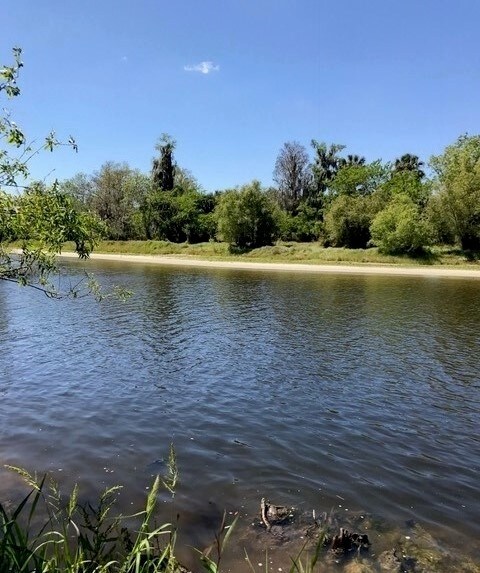
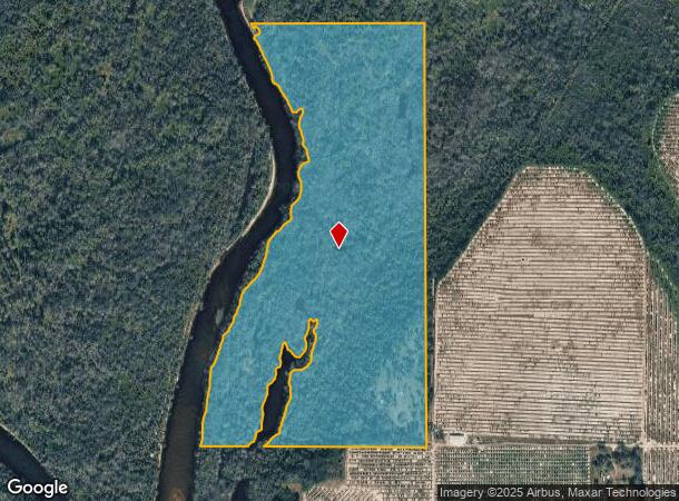
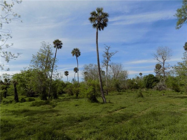
Property Record
6256 Sw Hill St, Arcadia, FL 34269
NEARBY LISTINGS FOR SALE OR LEASE
Property Detail
6256 Sw Hill St
Arcadia, FL
Peace River Est East Unit One
31-38-24-0000-0030-0000
W1/2 OF SE1/4 LYG E OF RUN OF PEACE RIVER OR 381/373 OR 560/177 INST:202114006688
Miscellaneous
DeSoto
AE
Florida
12027C0164D
59 AC
2024
Florida Central South Area
2024
Other Market Areas
010405
DEMOGRAPHICS near 6256 Sw Hill St
1 Mile
3 Mile
5 Mile
2024 Total Population
85
561
3,909
2029 Population
92
611
4,270
Pop Growth 2024-2029
+ 8.24%
+ 8.91%
+ 9.24%
Average Age
41
42
46
2024 Total Households
30
202
1,522
HH Growth 2024-2029
+ 10.00%
+ 9.41%
+ 9.92%
Median Household Inc
$46,000
$47,083
$48,877
Avg Household Size
2.50
2.60
2.40
2024 Avg HH Vehicles
2.00
2.00
2.00
Median Home Value
$233,333
$243,750
$163,846
Median Year Built
1988
1988
1990
Nearby Places
Map Layers
Map Styles
 Street
 Aerial
- Restaurants
- Banks
- Shops
- Fitness
- Groceries
PUBLIC TRANSPORTATION
AIRPORT
Punta Gorda
DRIVE
WALK
Distance
Punta Gorda
33 min
19.8 mi
Freight Ports
Port Manatee
DRIVE
WALK
Distance
Port Manatee
98 min
67.2 mi
SALE & LEASE HISTORY
LISTING DATE
SALE/LEASE

Sep 27, 2017
For Sale
May 07, 2018
For Sale
Dec 30, 2019
For Sale
Nearby Properties
Address
Land Use
TOTAL SIZE
Lot Size
Zoning
Address
Land Use
TOTAL SIZE
Lot Size
Zoning
2,768 SF
285 AC
A-10
Address
Land Use
TOTAL SIZE
Lot Size
Zoning
351 AC
A-10
Address
Land Use
TOTAL SIZE
Lot Size
Zoning
181 AC
A-5
Address
Land Use
TOTAL SIZE
Lot Size
Zoning
98.17 AC
A-10
Address
Land Use
TOTAL SIZE
Lot Size
Zoning
4,405 SF
5.10 AC
A-5
Address
Land Use
TOTAL SIZE
Lot Size
Zoning
172 AC
A-5
Address
Land Use
TOTAL SIZE
Lot Size
Zoning
52.20 AC
A-5
Address
Land Use
TOTAL SIZE
Lot Size
Zoning
10,151 SF
3.33 AC
A-5
Address
Land Use
TOTAL SIZE
Lot Size
Zoning
137 AC
A-10
Address
Land Use
TOTAL SIZE
Lot Size
Zoning
14,149 SF
12.20 AC
A-10
Address
Land Use
TOTAL SIZE
Lot Size
Zoning
169 AC
A-10
Address
Land Use
TOTAL SIZE
Lot Size
Zoning
1,866 SF
7.72 AC
A-5
Address
Land Use
TOTAL SIZE
Lot Size
Zoning
160 AC
A-10
Address
Land Use
TOTAL SIZE
Lot Size
Zoning
125 AC
A-10
Address
Land Use
TOTAL SIZE
Lot Size
Zoning
4,160 SF
7.41 AC
A-5
Address
Land Use
TOTAL SIZE
Lot Size
Zoning
3,065 SF
4.90 AC
A-5
Address
Land Use
TOTAL SIZE
Lot Size
Zoning
100.50 AC
A-5
Address
Land Use
TOTAL SIZE
Lot Size
Zoning
143 AC
A-10
Address
Land Use
TOTAL SIZE
Lot Size
Zoning
122 AC
A-10
Address
Land Use
TOTAL SIZE
Lot Size
Zoning
44.06 AC
RMF-6
Address
Land Use
TOTAL SIZE
Lot Size
Zoning
1,152 SF
69 AC
A-10
Address
Land Use
TOTAL SIZE
Lot Size
Zoning
51 AC
RMF-6
Address
Land Use
TOTAL SIZE
Lot Size
Zoning
3,426 SF
6.87 AC
IL
Address
Land Use
TOTAL SIZE
Lot Size
Zoning
126 AC
A-10
Address
Land Use
TOTAL SIZE
Lot Size
Zoning
1,430 SF
186.36 AC
A-10
Address
Land Use
TOTAL SIZE
Lot Size
Zoning
76 AC
A-10
Address
Land Use
TOTAL SIZE
Lot Size
Zoning
323.91 AC
A-10
Address
Land Use
TOTAL SIZE
Lot Size
Zoning
120 AC
A-10
Address
Land Use
TOTAL SIZE
Lot Size
Zoning
7,202 SF
1.12 AC
ROI
Address
Land Use
TOTAL SIZE
Lot Size
Zoning
112.24 AC
A-10
The World's #1 Commercial Real Estate Marketplace
Connect with us
© 2026 CoStar Group
The information above has been obtained from sources believed reliable. While we do not doubt its accuracy we have not verified it and make no guarantee, warranty or representation about it. It is your responsibility to independently confirm its accuracy and completeness. Any projections, opinions, assumptions, or estimates used are for example only and do not represent the current or future performance of the property. The value of this transaction to you depends on tax and other factors which should be evaluated by your tax, financial, and legal advisors. You and your advisors should conduct a careful, independent investigation of the property to determine to your satisfaction the suitability of the property for your needs.