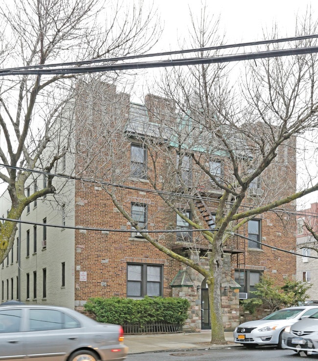
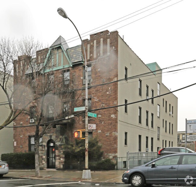
Property Record
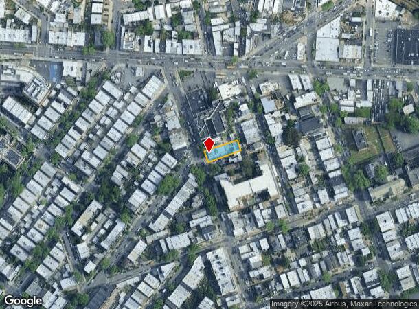
6259 Forest Ave, Ridgewood, NY 11385
NEARBY LISTINGS FOR SALE OR LEASE
Property Detail
6259 Forest Ave
03492-0021
Map Property George Ricard & Francis F L
Multifamilydwelling
Queens
X
New York
3604970209F
21
2024
0.16 AC
2025
Ridgewood
059501
Long Island (New York)
9,720 SF
New York-Jersey City-White Plains, NY-NJ
DEMOGRAPHICS near 6259 Forest Ave
1 Mile
3 Mile
5 Mile
2024 Total Population
89,141
1,028,013
2,987,197
2029 Population
81,685
963,323
2,800,712
Pop Growth 2024-2029
(8.36%)
(6.29%)
(6.24%)
Average Age
38
38
39
2024 Total Households
31,975
374,600
1,193,219
HH Growth 2024-2029
(8.96%)
(6.63%)
(6.45%)
Median Household Inc
$73,533
$69,342
$77,353
Avg Household Size
2.70
2.60
2.40
2024 Avg HH Vehicles
1.00
1.00
.00
Median Home Value
$797,055
$746,175
$778,336
Median Year Built
1947
1949
1951
Nearby Places
- Restaurants
- Banks
- Shops
- Fitness
- Groceries
PUBLIC TRANSPORTATION
TRANSIT/SUBWAY
Fresh Pond Road (M - New York MTA Subway (The Subway))
DRIVE
WALK
Distance
Fresh Pond Road (M - New York MTA Subway (The Subway))
2 min
7 min
0.4 mi
Seneca Avenue (M - New York MTA Subway (The Subway))
DRIVE
WALK
Distance
Seneca Avenue (M - New York MTA Subway (The Subway))
3 min
14 min
0.7 mi
Middle Village-Metropolitan Avenue (M - New York MTA Subway (The Subway))
DRIVE
WALK
Distance
Middle Village-Metropolitan Avenue (M - New York MTA Subway (The Subway))
3 min
18 min
1.0 mi
Forest Avenue (M - New York MTA Subway (The Subway))
DRIVE
WALK
Distance
Forest Avenue (M - New York MTA Subway (The Subway))
4 min
19 min
1.0 mi
COMMUTER RAIL
Woodside Station (Babylon Branch - Long Island Rail Road, Far Rockaway Branch - Long Island Rail Road, Hempstead Branch - Long Island Rail Road, Long Beach Branch - Long Island Rail Road, Montauk Branch - Long Island Rail Road, Port Jefferson Branch - Long Island Rail Road, Port Washington Branch - Long Island Rail Road, Ronkonkoma Branch - Long Island Rail Road)
DRIVE
WALK
Distance
Woodside Station (Babylon Branch - Long Island Rail Road, Far Rockaway Branch - Long Island Rail Road, Hempstead Branch - Long Island Rail Road, Long Beach Branch - Long Island Rail Road, Montauk Branch - Long Island Rail Road, Port Jefferson Branch - Long Island Rail Road, Port Washington Branch - Long Island Rail Road, Ronkonkoma Branch - Long Island Rail Road)
12 min
3.0 mi
Hunterspoint Avenue Station (Hempstead Branch - Long Island Rail Road, Oyster Bay Branch - Long Island Rail Road)
DRIVE
WALK
Distance
Hunterspoint Avenue Station (Hempstead Branch - Long Island Rail Road, Oyster Bay Branch - Long Island Rail Road)
13 min
4.0 mi
AIRPORT
LaGuardia
DRIVE
WALK
Distance
LaGuardia
15 min
8.2 mi
John F Kennedy International
DRIVE
WALK
Distance
John F Kennedy International
18 min
11.7 mi
Newark Liberty International
DRIVE
WALK
Distance
Newark Liberty International
37 min
17.5 mi
Freight Ports
NY - Red Hook Container Terminal
DRIVE
WALK
Distance
NY - Red Hook Container Terminal
1 min
5.6 mi
Nearby Properties
Address
Land Use
TOTAL SIZE
Lot Size
Zoning
Address
Land Use
TOTAL SIZE
Lot Size
Zoning
2,812,739 SF
2.10 AC
C5-3
Address
Land Use
TOTAL SIZE
Lot Size
Zoning
1,502,532 SF
6.35 AC
R7B
Address
Land Use
TOTAL SIZE
Lot Size
Zoning
772,163 SF
5.24 AC
C4-5X
Address
Land Use
TOTAL SIZE
Lot Size
Zoning
54,170 SF
229.57 AC
PARK
Address
Land Use
TOTAL SIZE
Lot Size
Zoning
1,292,074 SF
C4-2F
Address
Land Use
TOTAL SIZE
Lot Size
Zoning
835,231 SF
11.32 AC
R6
Address
Land Use
TOTAL SIZE
Lot Size
Zoning
234,891 SF
3.17 AC
C4-5X
Address
Land Use
TOTAL SIZE
Lot Size
Zoning
777,258 SF
4.67 AC
M3-2
Address
Land Use
TOTAL SIZE
Lot Size
Zoning
863,800 SF
2.71 AC
M1-4
Address
Land Use
TOTAL SIZE
Lot Size
Zoning
264,691 SF
5.17 AC
M1-2
Address
Land Use
TOTAL SIZE
Lot Size
Zoning
1,119,826 SF
2.76 AC
M1-4
Address
Land Use
TOTAL SIZE
Lot Size
Zoning
1,000 SF
210.07 AC
R3-2
Address
Land Use
TOTAL SIZE
Lot Size
Zoning
1,572,198 SF
22.06 AC
M1-2
Address
Land Use
TOTAL SIZE
Lot Size
Zoning
344,116 SF
0.92 AC
R7-1
Address
Land Use
TOTAL SIZE
Lot Size
Zoning
826,915 SF
8.83 AC
M3-1
Address
Land Use
TOTAL SIZE
Lot Size
Zoning
446,763 SF
12.52 AC
R6
Address
Land Use
TOTAL SIZE
Lot Size
Zoning
1,150,500 SF
15.17 AC
R6
Address
Land Use
TOTAL SIZE
Lot Size
Zoning
360,000 SF
5.88 AC
C4-2
Address
Land Use
TOTAL SIZE
Lot Size
Zoning
307,038 SF
7.84 AC
M1-1
Address
Land Use
TOTAL SIZE
Lot Size
Zoning
363,205 SF
1.38 AC
M12R7A
Address
Land Use
TOTAL SIZE
Lot Size
Zoning
474,715 SF
1.72 AC
M14R8A
Address
Land Use
TOTAL SIZE
Lot Size
Zoning
458,778 SF
2.09 AC
R6
Address
Land Use
TOTAL SIZE
Lot Size
Zoning
490,600 SF
12.01 AC
M1-1
Address
Land Use
TOTAL SIZE
Lot Size
Zoning
432,024 SF
1.84 AC
M1-2
Address
Land Use
TOTAL SIZE
Lot Size
Zoning
248,200 SF
1.25 AC
R6
Address
Land Use
TOTAL SIZE
Lot Size
Zoning
257,660 SF
1.94 AC
R7A
Address
Land Use
TOTAL SIZE
Lot Size
Zoning
353,333 SF
1.99 AC
R6A
Address
Land Use
TOTAL SIZE
Lot Size
Zoning
780,000 SF
11.15 AC
R6
Address
Land Use
TOTAL SIZE
Lot Size
Zoning
550,909 SF
2.76 AC
M1-4
Address
Land Use
TOTAL SIZE
Lot Size
Zoning
88,700 SF
4.59 AC
M3-1
The World's #1 Commercial Real Estate Marketplace
Connect with us
© 2025 CoStar Group
The information above has been obtained from sources believed reliable. While we do not doubt its accuracy we have not verified it and make no guarantee, warranty or representation about it. It is your responsibility to independently confirm its accuracy and completeness. Any projections, opinions, assumptions, or estimates used are for example only and do not represent the current or future performance of the property. The value of this transaction to you depends on tax and other factors which should be evaluated by your tax, financial, and legal advisors. You and your advisors should conduct a careful, independent investigation of the property to determine to your satisfaction the suitability of the property for your needs.