Property Record
626 Main St, Dennis Port, MA 02639
NEARBY LISTINGS FOR SALE OR LEASE
Property Detail
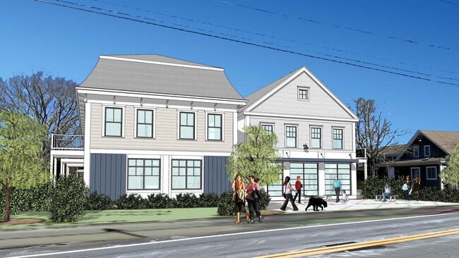
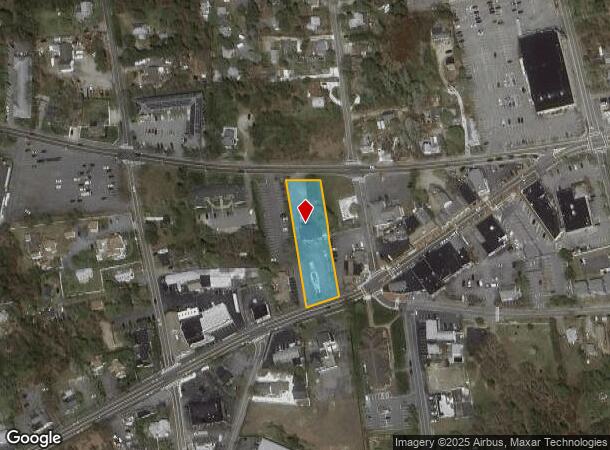
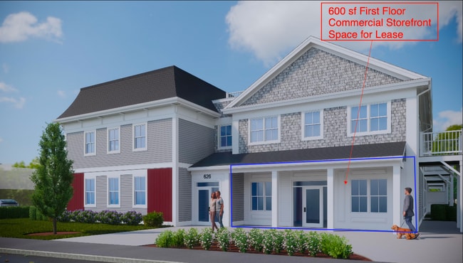
626 Main St
Restaurantbuilding
Barnstable
X
Massachusetts
25001C0592J
0.81 AC
2025
Cape Cod
2025
Other Market Areas
011300
Barnstable Town, MA
8,128 SF
DENN-000090-000000-000059
DEMOGRAPHICS near 626 Main St
1 Mile
3 Mile
5 Mile
2024 Total Population
3,762
15,626
39,809
2029 Population
3,933
16,497
41,592
Pop Growth 2024-2029
+ 4.55%
+ 5.57%
+ 4.48%
Average Age
50
53
51
2024 Total Households
1,924
7,825
18,944
HH Growth 2024-2029
+ 4.52%
+ 5.62%
+ 4.47%
Median Household Inc
$58,704
$66,425
$73,029
Avg Household Size
1.90
1.90
2.00
2024 Avg HH Vehicles
2.00
2.00
2.00
Median Home Value
$435,689
$482,660
$474,509
Median Year Built
1965
1967
1971
Nearby Places
Map Layers
Map Styles
 Street
 Aerial
- Restaurants
- Banks
- Shops
- Fitness
- Groceries
PUBLIC TRANSPORTATION
COMMUTER RAIL
DRIVE
WALK
Distance
17 min
8.9 mi
Freight Ports
Port of New Bedford Harbor
DRIVE
WALK
Distance
Port of New Bedford Harbor
80 min
57.2 mi
SALE & LEASE HISTORY
LISTING DATE
SALE/LEASE

May 15, 2023
For Sale
Nearby Properties
Address
Land Use
TOTAL SIZE
Lot Size
Zoning
Address
Land Use
TOTAL SIZE
Lot Size
Zoning
13.34 AC
E
Address
Land Use
TOTAL SIZE
Lot Size
Zoning
138,804 SF
15.94 AC
Address
Land Use
TOTAL SIZE
Lot Size
Zoning
Address
Land Use
TOTAL SIZE
Lot Size
Zoning
3.42 AC
Address
Land Use
TOTAL SIZE
Lot Size
Zoning
10.34 AC
Address
Land Use
TOTAL SIZE
Lot Size
Zoning
Address
Land Use
TOTAL SIZE
Lot Size
Zoning
3,480 SF
22.78 AC
E
Address
Land Use
TOTAL SIZE
Lot Size
Zoning
Address
Land Use
TOTAL SIZE
Lot Size
Zoning
14,844 SF
0.50 AC
Address
Land Use
TOTAL SIZE
Lot Size
Zoning
Address
Land Use
TOTAL SIZE
Lot Size
Zoning
Address
Land Use
TOTAL SIZE
Lot Size
Zoning
4.88 AC
E
Address
Land Use
TOTAL SIZE
Lot Size
Zoning
59,054 SF
9.53 AC
R
Address
Land Use
TOTAL SIZE
Lot Size
Zoning
1.52 AC
R
Address
Land Use
TOTAL SIZE
Lot Size
Zoning
2,003 SF
1.57 AC
R
Address
Land Use
TOTAL SIZE
Lot Size
Zoning
0.78 AC
R
Address
Land Use
TOTAL SIZE
Lot Size
Zoning
Address
Land Use
TOTAL SIZE
Lot Size
Zoning
6,276 SF
0.80 AC
R
Address
Land Use
TOTAL SIZE
Lot Size
Zoning
Address
Land Use
TOTAL SIZE
Lot Size
Zoning
0.80 AC
R
Address
Land Use
TOTAL SIZE
Lot Size
Zoning
9.77 AC
Address
Land Use
TOTAL SIZE
Lot Size
Zoning
14.54 AC
Address
Land Use
TOTAL SIZE
Lot Size
Zoning
45.75 AC
R
Address
Land Use
TOTAL SIZE
Lot Size
Zoning
0.41 AC
R
Address
Land Use
TOTAL SIZE
Lot Size
Zoning
1.55 AC
R
Address
Land Use
TOTAL SIZE
Lot Size
Zoning
1.03 AC
R
Address
Land Use
TOTAL SIZE
Lot Size
Zoning
4,744 SF
0.44 AC
R
Address
Land Use
TOTAL SIZE
Lot Size
Zoning
38,518 SF
5.09 AC
Address
Land Use
TOTAL SIZE
Lot Size
Zoning
62,423 SF
13.98 AC
Address
Land Use
TOTAL SIZE
Lot Size
Zoning
0.66 AC
R
The World's #1 Commercial Real Estate Marketplace
Connect with us
© 2025 CoStar Group
The information above has been obtained from sources believed reliable. While we do not doubt its accuracy we have not verified it and make no guarantee, warranty or representation about it. It is your responsibility to independently confirm its accuracy and completeness. Any projections, opinions, assumptions, or estimates used are for example only and do not represent the current or future performance of the property. The value of this transaction to you depends on tax and other factors which should be evaluated by your tax, financial, and legal advisors. You and your advisors should conduct a careful, independent investigation of the property to determine to your satisfaction the suitability of the property for your needs.