Property Record
626 Maple Ave, Cheshire, CT 06410

Property Detail
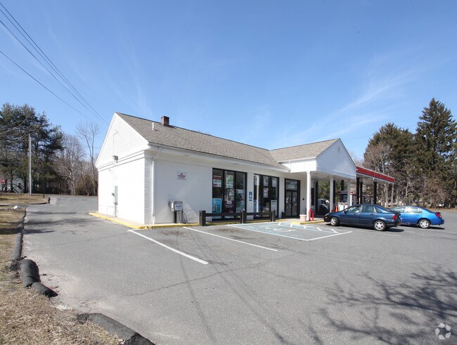
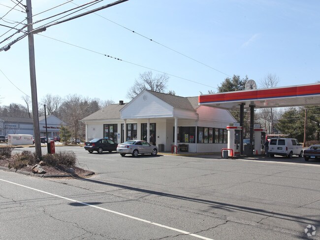
626 Maple Ave
Servicestation
Naugatuck Vly
C-2
Connecticut
B and X Area of moderate flood hazard, usually the area between the limits of the 100-year and 500-year floods.
0.65 AC
2025
Cheshire
2025
Westchester/So Connecticut
343102
New Haven, CT
1,742 SF
CHES-000050-000280
NEARBY LISTINGS FOR SALE OR LEASE
DEMOGRAPHICS near 626 Maple Ave
1 mile
3 mile
5 mile
2025 Total Population
5,355
26,252
95,332
2030 Population
5,513
26,915
97,177
Pop Growth 2025-2030
+ 2.95%
+ 2.53%
+ 1.94%
Average Age
43
43
43
2025 Total Households
2,059
9,527
36,461
HH Growth 2025-2030
+ 3.16%
+ 2.65%
+ 1.97%
Median Household Inc
$106,481
$129,721
$97,865
Avg Household Size
2.50
2.60
2.50
2025 Avg HH Vehicles
2.00
2.00
2.00
Median Home Value
$393,570
$426,479
$356,810
Median Year Built
1965
1971
1969
Nearby Places
Map Layers
Map Styles
 Street
 Aerial
Transit
 Traffic
 Biking
Places
Listings with unknown addresses are not visible on the map
- Restaurants
- Banks
- Shops
- Fitness
- Groceries
PUBLIC TRANSPORTATION
COMMUTER RAIL
Meriden (Hartford Line - CONN DOT)
Drive
Walk
Distance
Meriden (Hartford Line - CONN DOT)
10 min
8.3 mi
Wallingford (Hartford Line - CONN DOT)
Drive
Walk
Distance
Wallingford (Hartford Line - CONN DOT)
14 min
8.5 mi
AIRPORT
Tweed/New Haven
Drive
Walk
Distance
Tweed/New Haven
30 min
19.9 mi
Freight Ports
Port of New Haven
Drive
Walk
Distance
Port of New Haven
26 min
17.6 mi
Nearby Properties
Address
Land Use
TOTAL SIZE
Lot Size
Zoning
Address
Land Use
TOTAL SIZE
Lot Size
Zoning
1,664 SF
166.95 AC
I-2
Address
Land Use
TOTAL SIZE
Lot Size
Zoning
72,415 SF
48.10 AC
R-20
Address
Land Use
TOTAL SIZE
Lot Size
Zoning
313,293 SF
53.21 AC
I-1
Address
Land Use
TOTAL SIZE
Lot Size
Zoning
168,763 SF
107.36 AC
R-40
Address
Land Use
TOTAL SIZE
Lot Size
Zoning
5,600 SF
59 AC
R-40
Address
Land Use
TOTAL SIZE
Lot Size
Zoning
531,397 SF
82.40 AC
I-2
Address
Land Use
TOTAL SIZE
Lot Size
Zoning
24.80 AC
R-20A
Address
Land Use
TOTAL SIZE
Lot Size
Zoning
243,820 SF
39.42 AC
I-2
Address
Land Use
TOTAL SIZE
Lot Size
Zoning
12,250 SF
101.84 AC
R-40
Address
Land Use
TOTAL SIZE
Lot Size
Zoning
116,196 SF
9.45 AC
R-20
Address
Land Use
TOTAL SIZE
Lot Size
Zoning
41,198 SF
2.59 AC
C-1
Address
Land Use
TOTAL SIZE
Lot Size
Zoning
69,492 SF
25 AC
R-40
Address
Land Use
TOTAL SIZE
Lot Size
Zoning
281,623 SF
39.24 AC
I-2
Address
Land Use
TOTAL SIZE
Lot Size
Zoning
41,031 SF
17.07 AC
R-20
Address
Land Use
TOTAL SIZE
Lot Size
Zoning
12,960 SF
12.25 AC
R-20
Address
Land Use
TOTAL SIZE
Lot Size
Zoning
172,891 SF
75 AC
I-2
Address
Land Use
TOTAL SIZE
Lot Size
Zoning
241,500 SF
16.93 AC
I-1
Address
Land Use
TOTAL SIZE
Lot Size
Zoning
10,876 SF
5.73 AC
AHD
Address
Land Use
TOTAL SIZE
Lot Size
Zoning
67,494 SF
8.38 AC
C-3
Address
Land Use
TOTAL SIZE
Lot Size
Zoning
62,955 SF
2.76 AC
C-2
Address
Land Use
TOTAL SIZE
Lot Size
Zoning
46,950 SF
6.71 AC
C-3
Address
Land Use
TOTAL SIZE
Lot Size
Zoning
154,702 SF
33.86 AC
I-2
Address
Land Use
TOTAL SIZE
Lot Size
Zoning
14,200 SF
19.20 AC
I-2
Address
Land Use
TOTAL SIZE
Lot Size
Zoning
35,463 SF
2.03 AC
R-20
Address
Land Use
TOTAL SIZE
Lot Size
Zoning
48,960 SF
5.94 AC
R-20
Address
Land Use
TOTAL SIZE
Lot Size
Zoning
57,572 SF
9.87 AC
I-1
Address
Land Use
TOTAL SIZE
Lot Size
Zoning
143,115 SF
13.14 AC
I-2
Address
Land Use
TOTAL SIZE
Lot Size
Zoning
72,224 SF
9.09 AC
I-2
Address
Land Use
TOTAL SIZE
Lot Size
Zoning
25,200 SF
5.80 AC
I-2
Address
Land Use
TOTAL SIZE
Lot Size
Zoning
23,590 SF
12.30 AC
R-20
The World's #1 Commercial Real Estate Marketplace
Connect with us
© 2026 CoStar Group
The information above has been obtained from sources believed reliable. While we do not doubt its accuracy we have not verified it and make no guarantee, warranty or representation about it. It is your responsibility to independently confirm its accuracy and completeness. Any projections, opinions, assumptions, or estimates used are for example only and do not represent the current or future performance of the property. The value of this transaction to you depends on tax and other factors which should be evaluated by your tax, financial, and legal advisors. You and your advisors should conduct a careful, independent investigation of the property to determine to your satisfaction the suitability of the property for your needs.