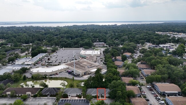
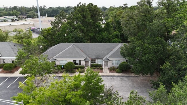
Property Record
6260 Dupont Station Ct E, Jacksonville, FL 32217
Current Lease Availabilities
NEARBY LISTINGS FOR SALE OR LEASE
Property Detail
6260 Dupont Station Ct E
Jacksonville, FL
Metro South Executive Pk
154166-2020
56-3S-27E METRO SOUTH EXECUTIVE PARK CONDOMINIUM UNIT C 1/4TH INT COMMON ELEMENTS O/R 11313-7
Officecondo
Duval
X
Florida
12031C0388H
c
2024
0.01 AC
2025
San Marco
016606
Jacksonville (Florida)
1,100 SF
DEMOGRAPHICS near 6260 Dupont Station Ct E
1 Mile
3 Mile
5 Mile
2024 Total Population
9,073
61,435
165,405
2029 Population
9,528
64,492
174,217
Pop Growth 2024-2029
+ 5.01%
+ 4.98%
+ 5.33%
Average Age
40
40
39
2024 Total Households
3,747
25,175
72,110
HH Growth 2024-2029
+ 5.12%
+ 5.10%
+ 5.56%
Median Household Inc
$41,899
$56,532
$59,125
Avg Household Size
2.30
2.30
2.20
2024 Avg HH Vehicles
1.00
2.00
2.00
Median Home Value
$281,793
$241,941
$251,690
Median Year Built
1971
1970
1980
Nearby Places
Map Layers
Map Styles
 Street
 Aerial
- Restaurants
- Banks
- Shops
- Fitness
- Groceries
PUBLIC TRANSPORTATION
AIRPORT
Jacksonville International
DRIVE
WALK
Distance
Jacksonville International
36 min
22.0 mi
Nearby Properties
Address
Land Use
TOTAL SIZE
Lot Size
Zoning
Address
Land Use
TOTAL SIZE
Lot Size
Zoning
875,866 SF
22.33 AC
PBF-3
Address
Land Use
TOTAL SIZE
Lot Size
Zoning
371,466 SF
49.16 AC
PBF-2
Address
Land Use
TOTAL SIZE
Lot Size
Zoning
273,196 SF
16.57 AC
PUD
Address
Land Use
TOTAL SIZE
Lot Size
Zoning
316,705 SF
15.44 AC
PUD
Address
Land Use
TOTAL SIZE
Lot Size
Zoning
193,941 SF
7.35 AC
PUD
Address
Land Use
TOTAL SIZE
Lot Size
Zoning
313,009 SF
22.50 AC
RMD-D
Address
Land Use
TOTAL SIZE
Lot Size
Zoning
415,146 SF
19.27 AC
RMD-D
Address
Land Use
TOTAL SIZE
Lot Size
Zoning
93,059 SF
8.54 AC
CCG-2
Address
Land Use
TOTAL SIZE
Lot Size
Zoning
379,026 SF
24.02 AC
PUD
Address
Land Use
TOTAL SIZE
Lot Size
Zoning
283,237 SF
28.01 AC
PBF-2
Address
Land Use
TOTAL SIZE
Lot Size
Zoning
169,086 SF
10.01 AC
PUD
Address
Land Use
TOTAL SIZE
Lot Size
Zoning
259,291 SF
15.01 AC
RMD-D
Address
Land Use
TOTAL SIZE
Lot Size
Zoning
294,353 SF
14.58 AC
RMD-D
Address
Land Use
TOTAL SIZE
Lot Size
Zoning
129,587 SF
16.91 AC
IBP
Address
Land Use
TOTAL SIZE
Lot Size
Zoning
242,630 SF
22.85 AC
PUD
Address
Land Use
TOTAL SIZE
Lot Size
Zoning
257,667 SF
3.91 AC
CCBD
Address
Land Use
TOTAL SIZE
Lot Size
Zoning
191,207 SF
23.44 AC
IBP
Address
Land Use
TOTAL SIZE
Lot Size
Zoning
266,156 SF
11.54 AC
RMD-D
Address
Land Use
TOTAL SIZE
Lot Size
Zoning
372,759 SF
25.01 AC
RMD-D
Address
Land Use
TOTAL SIZE
Lot Size
Zoning
72,315 SF
7.15 AC
CCG-1
Address
Land Use
TOTAL SIZE
Lot Size
Zoning
213,028 SF
24.21 AC
CRO
Address
Land Use
TOTAL SIZE
Lot Size
Zoning
197,217 SF
18.96 AC
IBP
Address
Land Use
TOTAL SIZE
Lot Size
Zoning
178,954 SF
11.22 AC
RMD-D
Address
Land Use
TOTAL SIZE
Lot Size
Zoning
223,067 SF
14.74 AC
IBP
Address
Land Use
TOTAL SIZE
Lot Size
Zoning
150,073 SF
11.23 AC
CCG-1
Address
Land Use
TOTAL SIZE
Lot Size
Zoning
213,474 SF
25.32 AC
IBP
Address
Land Use
TOTAL SIZE
Lot Size
Zoning
106,388 SF
20.53 AC
PUD
Address
Land Use
TOTAL SIZE
Lot Size
Zoning
173,333 SF
10.74 AC
RMD-D
Address
Land Use
TOTAL SIZE
Lot Size
Zoning
60,464 SF
8.13 AC
CCG-2
Address
Land Use
TOTAL SIZE
Lot Size
Zoning
155,267 SF
13.33 AC
CRO
The World's #1 Commercial Real Estate Marketplace
Connect with us
© 2025 CoStar Group
The information above has been obtained from sources believed reliable. While we do not doubt its accuracy we have not verified it and make no guarantee, warranty or representation about it. It is your responsibility to independently confirm its accuracy and completeness. Any projections, opinions, assumptions, or estimates used are for example only and do not represent the current or future performance of the property. The value of this transaction to you depends on tax and other factors which should be evaluated by your tax, financial, and legal advisors. You and your advisors should conduct a careful, independent investigation of the property to determine to your satisfaction the suitability of the property for your needs.