Property Record
6260 W Mcintyre St, Golden, CO 80403
NEARBY LISTINGS FOR SALE OR LEASE
-
-
View all Golden listings for sale on LoopNet.com
Property Detail
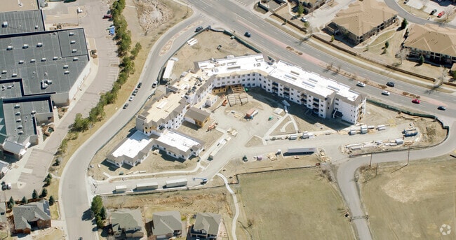
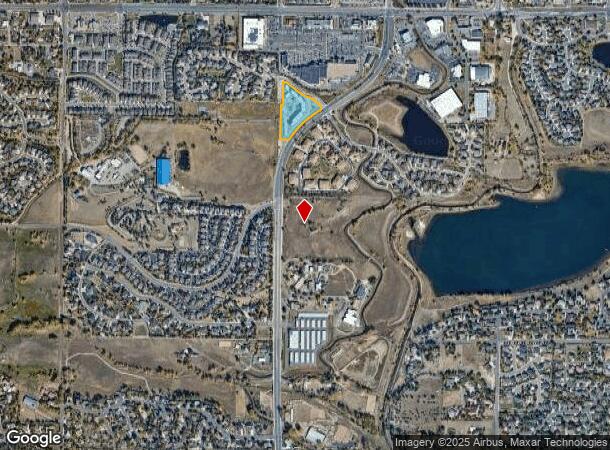
6260 W Mcintyre St
Denver
Cherrywood Pointe Final
Denver-Aurora-Centennial, CO
SECTION 12 TOWNSHIP 03 RANGE 70 SUBDIVISIONCD 1000002 SUBDIVISIONNAME CHERRYWOOD POINTE FINAL LOT 0001 SIZE: 184934 TRACT 00A VALUE: 4.245
30-121-07-003
Jefferson
Multifamilydwelling
Colorado
2023
1
2024
4.25 AC
009851
Outer North Jefferson County
156,775 SF
DEMOGRAPHICS near 6260 W Mcintyre St
1 Mile
3 Mile
5 Mile
2024 Total Population
6,664
48,607
144,066
2029 Population
6,541
47,973
142,823
Pop Growth 2024-2029
(1.85%)
(1.30%)
(0.86%)
Average Age
44
43
42
2024 Total Households
2,605
18,721
57,626
HH Growth 2024-2029
(1.92%)
(1.36%)
(0.94%)
Median Household Inc
$136,508
$122,029
$105,188
Avg Household Size
2.50
2.50
2.40
2024 Avg HH Vehicles
2.00
2.00
2.00
Median Home Value
$726,129
$676,538
$661,130
Median Year Built
1999
1990
1979
Nearby Places
Map Layers
Map Styles
 Street
 Aerial
- Restaurants
- Banks
- Shops
- Fitness
- Groceries
PUBLIC TRANSPORTATION
COMMUTER RAIL
Wheat Ridge - Ward Station Track 1 (Union Station to Wheat Ridge Ward Station - Regional Transportation District)
DRIVE
WALK
Distance
Wheat Ridge - Ward Station Track 1 (Union Station to Wheat Ridge Ward Station - Regional Transportation District)
8 min
4.2 mi
Arvada Ridge Station Track 1 (Union Station to Wheat Ridge Ward Station - Regional Transportation District)
DRIVE
WALK
Distance
Arvada Ridge Station Track 1 (Union Station to Wheat Ridge Ward Station - Regional Transportation District)
8 min
5.0 mi
AIRPORT
Denver International
DRIVE
WALK
Distance
Denver International
45 min
34.4 mi
Freight Ports
Tulsa Port Of Catoosa
DRIVE
WALK
Distance
Tulsa Port Of Catoosa
742 min
719.9 mi
Nearby Properties
Address
Land Use
TOTAL SIZE
Lot Size
Zoning
Address
Land Use
TOTAL SIZE
Lot Size
Zoning
830,160 SF
26.93 AC
Address
Land Use
TOTAL SIZE
Lot Size
Zoning
269,013 SF
31.89 AC
Address
Land Use
TOTAL SIZE
Lot Size
Zoning
253,643 SF
50.87 AC
A2
Address
Land Use
TOTAL SIZE
Lot Size
Zoning
353,286 SF
14.49 AC
Address
Land Use
TOTAL SIZE
Lot Size
Zoning
227,132 SF
11.95 AC
Address
Land Use
TOTAL SIZE
Lot Size
Zoning
365,230 SF
12.51 AC
Address
Land Use
TOTAL SIZE
Lot Size
Zoning
1,115,227 SF
84.74 AC
I2
Address
Land Use
TOTAL SIZE
Lot Size
Zoning
192,500 SF
10.97 AC
Address
Land Use
TOTAL SIZE
Lot Size
Zoning
260,325 SF
13.70 AC
Address
Land Use
TOTAL SIZE
Lot Size
Zoning
215,878 SF
11.82 AC
A2
Address
Land Use
TOTAL SIZE
Lot Size
Zoning
131,135 SF
2.83 AC
Address
Land Use
TOTAL SIZE
Lot Size
Zoning
363,989 SF
30.10 AC
Address
Land Use
TOTAL SIZE
Lot Size
Zoning
101,761 SF
4.34 AC
Address
Land Use
TOTAL SIZE
Lot Size
Zoning
520,896 SF
24.42 AC
I1
Address
Land Use
TOTAL SIZE
Lot Size
Zoning
130,662 SF
9.67 AC
Address
Land Use
TOTAL SIZE
Lot Size
Zoning
223,338 SF
9.42 AC
I1
Address
Land Use
TOTAL SIZE
Lot Size
Zoning
149,760 SF
8.64 AC
Address
Land Use
TOTAL SIZE
Lot Size
Zoning
64,883 SF
4.74 AC
Address
Land Use
TOTAL SIZE
Lot Size
Zoning
82,055 SF
19.39 AC
Address
Land Use
TOTAL SIZE
Lot Size
Zoning
67,520 SF
6.46 AC
Address
Land Use
TOTAL SIZE
Lot Size
Zoning
51,987 SF
15.23 AC
PD
Address
Land Use
TOTAL SIZE
Lot Size
Zoning
83,684 SF
8.15 AC
Address
Land Use
TOTAL SIZE
Lot Size
Zoning
50,853 SF
3.94 AC
Address
Land Use
TOTAL SIZE
Lot Size
Zoning
201,582 SF
5.78 AC
Address
Land Use
TOTAL SIZE
Lot Size
Zoning
123,448 SF
7.80 AC
Address
Land Use
TOTAL SIZE
Lot Size
Zoning
67,879 SF
9.91 AC
A2
Address
Land Use
TOTAL SIZE
Lot Size
Zoning
68,500 SF
5.84 AC
Address
Land Use
TOTAL SIZE
Lot Size
Zoning
54,236 SF
8.72 AC
Address
Land Use
TOTAL SIZE
Lot Size
Zoning
113,455 SF
7.98 AC
Address
Land Use
TOTAL SIZE
Lot Size
Zoning
175,599 SF
17.23 AC
The World's #1 Commercial Real Estate Marketplace
Connect with us
© 2026 CoStar Group
The information above has been obtained from sources believed reliable. While we do not doubt its accuracy we have not verified it and make no guarantee, warranty or representation about it. It is your responsibility to independently confirm its accuracy and completeness. Any projections, opinions, assumptions, or estimates used are for example only and do not represent the current or future performance of the property. The value of this transaction to you depends on tax and other factors which should be evaluated by your tax, financial, and legal advisors. You and your advisors should conduct a careful, independent investigation of the property to determine to your satisfaction the suitability of the property for your needs.