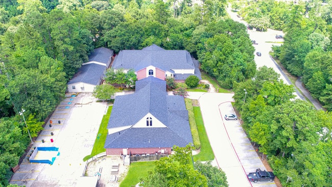
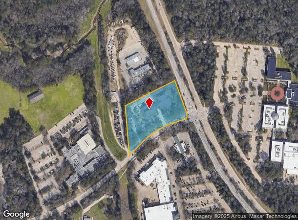
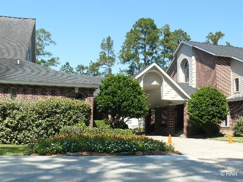
Property Record
6265 Shadow Bend Pl, Spring, TX 77381
NEARBY LISTINGS FOR SALE OR LEASE
-
-
View all Spring listings for sale on LoopNet.com
Property Detail
6265 Shadow Bend Pl
0687-00-00113
Roach H G
Commercialnec
A0687 ROACH H G, TRACT 1P-6, ACRES 2.651
X
Montgomery
48339C0530G
Texas
0
2.65 AC
2025
The Woodlands
691000
Houston
30,222 SF
Houston-The Woodlands-Sugar Land, TX
DEMOGRAPHICS near 6265 Shadow Bend Pl
1 Mile
3 Mile
5 Mile
2024 Total Population
5,761
67,746
176,196
2029 Population
6,963
82,664
211,121
Pop Growth 2024-2029
+ 20.86%
+ 22.02%
+ 19.82%
Average Age
43
42
39
2024 Total Households
2,121
27,991
67,729
HH Growth 2024-2029
+ 21.07%
+ 22.48%
+ 20.52%
Median Household Inc
$166,726
$107,871
$109,343
Avg Household Size
2.70
2.40
2.60
2024 Avg HH Vehicles
2.00
2.00
2.00
Median Home Value
$454,878
$382,093
$371,833
Median Year Built
1991
1996
2002
Nearby Places
Map Layers
Map Styles
 Street
 Aerial
- Restaurants
- Banks
- Shops
- Fitness
- Groceries
PUBLIC TRANSPORTATION
AIRPORT
George Bush Intcntl/Houston
DRIVE
WALK
Distance
George Bush Intcntl/Houston
32 min
24.5 mi
Freight Ports
Port of Houston
DRIVE
WALK
Distance
Port of Houston
55 min
40.2 mi
SALE & LEASE HISTORY
LISTING DATE
SALE/LEASE

Jun 21, 2019
For Sale
Nearby Properties
Address
Land Use
TOTAL SIZE
Lot Size
Zoning
Address
Land Use
TOTAL SIZE
Lot Size
Zoning
1,416,950 SF
21.80 AC
Address
Land Use
TOTAL SIZE
Lot Size
Zoning
1,673,574 SF
5.10 AC
Address
Land Use
TOTAL SIZE
Lot Size
Zoning
855,268 SF
31.65 AC
6
Address
Land Use
TOTAL SIZE
Lot Size
Zoning
743,246 SF
40.65 AC
Address
Land Use
TOTAL SIZE
Lot Size
Zoning
465,986 SF
21.55 AC
Address
Land Use
TOTAL SIZE
Lot Size
Zoning
718,313 SF
33.62 AC
Address
Land Use
TOTAL SIZE
Lot Size
Zoning
709,789 SF
3.04 AC
Address
Land Use
TOTAL SIZE
Lot Size
Zoning
1,053,284 SF
2.25 AC
Address
Land Use
TOTAL SIZE
Lot Size
Zoning
707,184 SF
3.48 AC
Address
Land Use
TOTAL SIZE
Lot Size
Zoning
813,318 SF
20.95 AC
Address
Land Use
TOTAL SIZE
Lot Size
Zoning
565,113 SF
4.52 AC
Address
Land Use
TOTAL SIZE
Lot Size
Zoning
469,813 SF
3.16 AC
Address
Land Use
TOTAL SIZE
Lot Size
Zoning
225,149 SF
1.07 AC
Address
Land Use
TOTAL SIZE
Lot Size
Zoning
670,665 SF
6.70 AC
Address
Land Use
TOTAL SIZE
Lot Size
Zoning
370,039 SF
40.66 AC
Address
Land Use
TOTAL SIZE
Lot Size
Zoning
571,041 SF
4.82 AC
Address
Land Use
TOTAL SIZE
Lot Size
Zoning
508,985 SF
29.47 AC
6
Address
Land Use
TOTAL SIZE
Lot Size
Zoning
438,062 SF
4.54 AC
Address
Land Use
TOTAL SIZE
Lot Size
Zoning
1,132,062 SF
3.31 AC
Address
Land Use
TOTAL SIZE
Lot Size
Zoning
502,255 SF
15.42 AC
6
Address
Land Use
TOTAL SIZE
Lot Size
Zoning
410,156 SF
18.68 AC
Address
Land Use
TOTAL SIZE
Lot Size
Zoning
579,596 SF
1.32 AC
Address
Land Use
TOTAL SIZE
Lot Size
Zoning
473,060 SF
10.07 AC
Address
Land Use
TOTAL SIZE
Lot Size
Zoning
392,960 SF
20.01 AC
6
Address
Land Use
TOTAL SIZE
Lot Size
Zoning
514,121 SF
2.01 AC
Address
Land Use
TOTAL SIZE
Lot Size
Zoning
336,730 SF
2.41 AC
Address
Land Use
TOTAL SIZE
Lot Size
Zoning
383,484 SF
4.67 AC
Address
Land Use
TOTAL SIZE
Lot Size
Zoning
246,719 SF
1.25 AC
Address
Land Use
TOTAL SIZE
Lot Size
Zoning
880,985 SF
99.32 AC
6
Address
Land Use
TOTAL SIZE
Lot Size
Zoning
189,537 SF
13.52 AC
The World's #1 Commercial Real Estate Marketplace
Connect with us
© 2025 CoStar Group
The information above has been obtained from sources believed reliable. While we do not doubt its accuracy we have not verified it and make no guarantee, warranty or representation about it. It is your responsibility to independently confirm its accuracy and completeness. Any projections, opinions, assumptions, or estimates used are for example only and do not represent the current or future performance of the property. The value of this transaction to you depends on tax and other factors which should be evaluated by your tax, financial, and legal advisors. You and your advisors should conduct a careful, independent investigation of the property to determine to your satisfaction the suitability of the property for your needs.