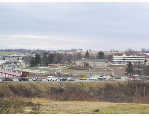
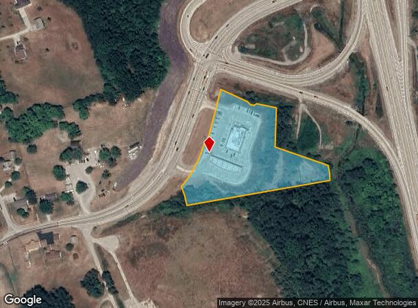
Property Record
6266 State Route 819, Scottdale, PA 15683
NEARBY LISTINGS FOR SALE OR LEASE
-
-
View all Scottdale listings for sale on LoopNet.com
Property Detail
6266 State Route 819
47-14-00-0-019
PCL 1, STORE, PAVEMENT YANUCK PLAN
Commercialofficeresidentialmixeduse
Westmoreland
X
Pennsylvania
42051C0206E
3.83 AC
2025
Westmoreland County
2025
Pittsburgh
806400
Pittsburgh, PA
1,903 SF
DEMOGRAPHICS near 6266 State Route 819
1 Mile
3 Mile
5 Mile
2024 Total Population
1,425
18,760
26,201
2029 Population
1,417
18,581
25,860
Pop Growth 2024-2029
(0.56%)
(0.95%)
(1.30%)
Average Age
47
45
45
2024 Total Households
640
8,212
11,419
HH Growth 2024-2029
(0.63%)
(1.05%)
(1.38%)
Median Household Inc
$88,686
$53,514
$54,784
Avg Household Size
2.20
2.20
2.30
2024 Avg HH Vehicles
2.00
2.00
2.00
Median Home Value
$136,702
$138,910
$148,265
Median Year Built
1976
1958
1963
Nearby Places
Map Layers
Map Styles
 Street
 Aerial
- Restaurants
- Banks
- Shops
- Fitness
- Groceries
PUBLIC TRANSPORTATION
COMMUTER RAIL
Connellsville Amtrak (Capitol Limited - Amtrak)
DRIVE
WALK
Distance
Connellsville Amtrak (Capitol Limited - Amtrak)
10 min
8.0 mi
AIRPORT
Arnold Palmer Regional
DRIVE
WALK
Distance
Arnold Palmer Regional
32 min
18.5 mi
Freight Ports
Port of Baltimore
DRIVE
WALK
Distance
Port of Baltimore
254 min
223.9 mi
Nearby Properties
Address
Land Use
TOTAL SIZE
Lot Size
Zoning
Address
Land Use
TOTAL SIZE
Lot Size
Zoning
14.10 AC
Address
Land Use
TOTAL SIZE
Lot Size
Zoning
85.10 AC
Address
Land Use
TOTAL SIZE
Lot Size
Zoning
184,955 SF
15.11 AC
Address
Land Use
TOTAL SIZE
Lot Size
Zoning
384,744 SF
17.81 AC
Address
Land Use
TOTAL SIZE
Lot Size
Zoning
Address
Land Use
TOTAL SIZE
Lot Size
Zoning
Address
Land Use
TOTAL SIZE
Lot Size
Zoning
Address
Land Use
TOTAL SIZE
Lot Size
Zoning
59,472 SF
15.35 AC
Address
Land Use
TOTAL SIZE
Lot Size
Zoning
15,035 SF
55.77 AC
Address
Land Use
TOTAL SIZE
Lot Size
Zoning
32.10 AC
Address
Land Use
TOTAL SIZE
Lot Size
Zoning
Address
Land Use
TOTAL SIZE
Lot Size
Zoning
40,000 SF
11.80 AC
Address
Land Use
TOTAL SIZE
Lot Size
Zoning
Address
Land Use
TOTAL SIZE
Lot Size
Zoning
Address
Land Use
TOTAL SIZE
Lot Size
Zoning
Address
Land Use
TOTAL SIZE
Lot Size
Zoning
7.89 AC
Address
Land Use
TOTAL SIZE
Lot Size
Zoning
2.40 AC
Address
Land Use
TOTAL SIZE
Lot Size
Zoning
2.88 AC
Address
Land Use
TOTAL SIZE
Lot Size
Zoning
52,966 SF
26.67 AC
Address
Land Use
TOTAL SIZE
Lot Size
Zoning
Address
Land Use
TOTAL SIZE
Lot Size
Zoning
4.40 AC
Address
Land Use
TOTAL SIZE
Lot Size
Zoning
Address
Land Use
TOTAL SIZE
Lot Size
Zoning
30,575 SF
8 AC
Address
Land Use
TOTAL SIZE
Lot Size
Zoning
19,933 SF
11.20 AC
Address
Land Use
TOTAL SIZE
Lot Size
Zoning
7.57 AC
Address
Land Use
TOTAL SIZE
Lot Size
Zoning
Address
Land Use
TOTAL SIZE
Lot Size
Zoning
36,323 SF
10.60 AC
Address
Land Use
TOTAL SIZE
Lot Size
Zoning
47,880 SF
54.46 AC
Address
Land Use
TOTAL SIZE
Lot Size
Zoning
0.66 AC
Address
Land Use
TOTAL SIZE
Lot Size
Zoning
0.44 AC
The World's #1 Commercial Real Estate Marketplace
Connect with us
© 2026 CoStar Group
The information above has been obtained from sources believed reliable. While we do not doubt its accuracy we have not verified it and make no guarantee, warranty or representation about it. It is your responsibility to independently confirm its accuracy and completeness. Any projections, opinions, assumptions, or estimates used are for example only and do not represent the current or future performance of the property. The value of this transaction to you depends on tax and other factors which should be evaluated by your tax, financial, and legal advisors. You and your advisors should conduct a careful, independent investigation of the property to determine to your satisfaction the suitability of the property for your needs.