Property Record
627 3Rd St, Belvidere, NJ 07823
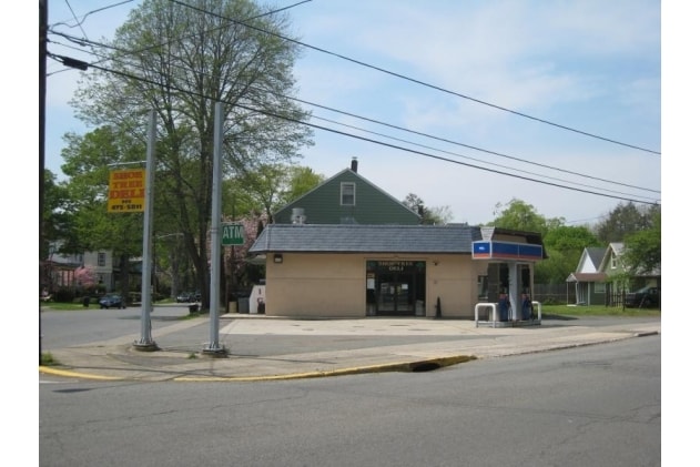

Property Detail
627 3Rd St
03-00020-0000-00010
Warren
Vacantlandnec
New Jersey
R50
10
B and X Area of moderate flood hazard, usually the area between the limits of the 100-year and 500-year floods.
0.12 AC
2024
Warren County
2025
Northern New Jersey
031700
Allentown-Bethlehem-Easton, PA-NJ
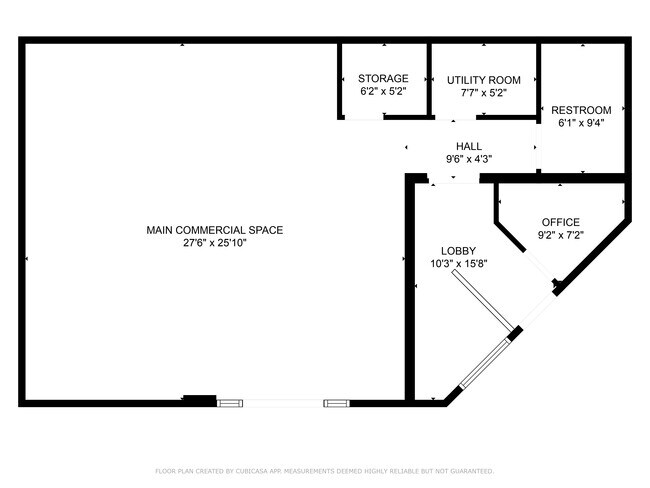
1,190 SF
NEARBY LISTINGS FOR SALE OR LEASE
DEMOGRAPHICS near 627 3Rd St
1 mile
3 mile
5 mile
2025 Total Population
3,426
6,778
15,504
2030 Population
3,501
6,896
15,755
Pop Growth 2025-2030
+ 2.19%
+ 1.74%
+ 1.62%
Average Age
47
49
47
2025 Total Households
1,537
3,056
6,574
HH Growth 2025-2030
+ 2.15%
+ 1.73%
+ 1.67%
Median Household Inc
$84,353
$81,189
$92,646
Avg Household Size
2.20
2.20
2.30
2025 Avg HH Vehicles
2.00
2.00
2.00
Median Home Value
$271,522
$308,726
$323,493
Median Year Built
1954
1975
1974
Nearby Places
Map Layers
Map Styles
 Street
 Aerial
Transit
 Traffic
 Biking
Places
Listings with unknown addresses are not visible on the map
- Restaurants
- Banks
- Shops
- Fitness
- Groceries
PUBLIC TRANSPORTATION
AIRPORT
Lehigh Valley International
Drive
Walk
Distance
Lehigh Valley International
45 min
26.7 mi
Freight Ports
New York Container Terminal
Drive
Walk
Distance
New York Container Terminal
87 min
64.8 mi
SALE & LEASE HISTORY
LISTING DATE
SALE/LEASE

Sep 19, 2017
For Sale
Oct 30, 2020
For Sale
Jan 20, 2021
For Sale
Nearby Properties
Address
Land Use
TOTAL SIZE
Lot Size
Zoning
Address
Land Use
TOTAL SIZE
Lot Size
Zoning
155.98 AC
I
Address
Land Use
TOTAL SIZE
Lot Size
Zoning
7,745 SF
12.50 AC
R100
Address
Land Use
TOTAL SIZE
Lot Size
Zoning
17,074 SF
60.46 AC
LM
Address
Land Use
TOTAL SIZE
Lot Size
Zoning
Address
Land Use
TOTAL SIZE
Lot Size
Zoning
800 SF
3.73 AC
Address
Land Use
TOTAL SIZE
Lot Size
Zoning
0.58 AC
CH-P
Address
Land Use
TOTAL SIZE
Lot Size
Zoning
7.17 AC
Address
Land Use
TOTAL SIZE
Lot Size
Zoning
65.27 AC
Address
Land Use
TOTAL SIZE
Lot Size
Zoning
31.53 AC
Address
Land Use
TOTAL SIZE
Lot Size
Zoning
15,000 SF
296.96 AC
I
Address
Land Use
TOTAL SIZE
Lot Size
Zoning
9,692 SF
3.26 AC
RM
Address
Land Use
TOTAL SIZE
Lot Size
Zoning
7,500 SF
4 AC
LM
Address
Land Use
TOTAL SIZE
Lot Size
Zoning
3.44 AC
CH-P
Address
Land Use
TOTAL SIZE
Lot Size
Zoning
Address
Land Use
TOTAL SIZE
Lot Size
Zoning
11.52 AC
Address
Land Use
TOTAL SIZE
Lot Size
Zoning
45.50 AC
Address
Land Use
TOTAL SIZE
Lot Size
Zoning
Address
Land Use
TOTAL SIZE
Lot Size
Zoning
217.87 AC
Address
Land Use
TOTAL SIZE
Lot Size
Zoning
864 SF
2.70 AC
LM
Address
Land Use
TOTAL SIZE
Lot Size
Zoning
5,696 SF
2.56 AC
Address
Land Use
TOTAL SIZE
Lot Size
Zoning
11,616 SF
1.12 AC
R50
Address
Land Use
TOTAL SIZE
Lot Size
Zoning
2,472 SF
0.44 AC
CH-P
Address
Land Use
TOTAL SIZE
Lot Size
Zoning
2,932 SF
0.65 AC
CH-P
Address
Land Use
TOTAL SIZE
Lot Size
Zoning
Address
Land Use
TOTAL SIZE
Lot Size
Zoning
2,268 SF
1.38 AC
R50
Address
Land Use
TOTAL SIZE
Lot Size
Zoning
3,612 SF
22.63 AC
I
Address
Land Use
TOTAL SIZE
Lot Size
Zoning
7,544 SF
0.58 AC
CH-P
Address
Land Use
TOTAL SIZE
Lot Size
Zoning
1,800 SF
9.75 AC
Address
Land Use
TOTAL SIZE
Lot Size
Zoning
46.04 AC
Address
Land Use
TOTAL SIZE
Lot Size
Zoning
The World's #1 Commercial Real Estate Marketplace
Connect with us
© 2026 CoStar Group
The information above has been obtained from sources believed reliable. While we do not doubt its accuracy we have not verified it and make no guarantee, warranty or representation about it. It is your responsibility to independently confirm its accuracy and completeness. Any projections, opinions, assumptions, or estimates used are for example only and do not represent the current or future performance of the property. The value of this transaction to you depends on tax and other factors which should be evaluated by your tax, financial, and legal advisors. You and your advisors should conduct a careful, independent investigation of the property to determine to your satisfaction the suitability of the property for your needs.