Property Record
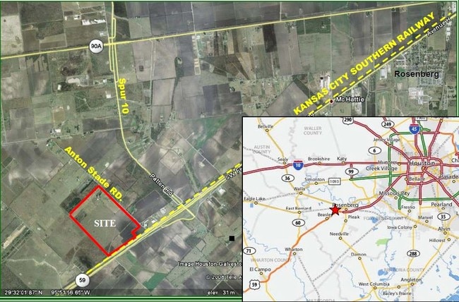
627 Anton Stade Rd, Rosenberg, TX 77471
NEARBY LISTINGS FOR SALE OR LEASE
Property Detail
627 Anton Stade Rd
0330-07-000-9110-903
S A And M G
Commercialnec
0330 S A AND M G, BLOCK 61 (PT), ACRES 1.00, (230 X 189.4)
X
Fort Bend
48157C0225L
Texas
2024
1.44 AC
2025
Southwest Outlier
675300
Houston
1,406 SF
Houston-Pasadena-The Woodlands, TX
DEMOGRAPHICS near 627 Anton Stade Rd
1 Mile
3 Mile
5 Mile
2024 Total Population
35
2,637
16,316
2029 Population
42
3,159
19,586
Pop Growth 2024-2029
+ 20.00%
+ 19.80%
+ 20.04%
Average Age
37
37
36
2024 Total Households
11
836
5,150
HH Growth 2024-2029
+ 18.18%
+ 20.33%
+ 20.56%
Median Household Inc
$67,500
$68,951
$65,804
Avg Household Size
3.20
3.20
3.10
2024 Avg HH Vehicles
2.00
2.00
2.00
Median Home Value
$125,000
$182,846
$198,264
Median Year Built
1984
1985
1994
Nearby Places
Map Layers
Map Styles
 Street
 Aerial
- Restaurants
- Banks
- Shops
- Fitness
- Groceries
SALE & LEASE HISTORY
LISTING DATE
SALE/LEASE

Sep 24, 2016
For Sale
Dec 11, 2018
For Sale
Nearby Properties
Address
Land Use
TOTAL SIZE
Lot Size
Zoning
Address
Land Use
TOTAL SIZE
Lot Size
Zoning
146.35 AC
ST
Address
Land Use
TOTAL SIZE
Lot Size
Zoning
672 SF
230.34 AC
YT
Address
Land Use
TOTAL SIZE
Lot Size
Zoning
37.08 AC
Address
Land Use
TOTAL SIZE
Lot Size
Zoning
66,896 SF
18.60 AC
ZNY
Address
Land Use
TOTAL SIZE
Lot Size
Zoning
100,000 SF
1.32 AC
Address
Land Use
TOTAL SIZE
Lot Size
Zoning
19.57 AC
OY
Address
Land Use
TOTAL SIZE
Lot Size
Zoning
208.52 AC
OST
Address
Land Use
TOTAL SIZE
Lot Size
Zoning
194.64 AC
Address
Land Use
TOTAL SIZE
Lot Size
Zoning
11,800 SF
9.26 AC
S
Address
Land Use
TOTAL SIZE
Lot Size
Zoning
105,350 SF
11.50 AC
R
Address
Land Use
TOTAL SIZE
Lot Size
Zoning
129.15 AC
Address
Land Use
TOTAL SIZE
Lot Size
Zoning
1,064 SF
68.45 AC
OQY
Address
Land Use
TOTAL SIZE
Lot Size
Zoning
51,250 SF
10.01 AC
S
Address
Land Use
TOTAL SIZE
Lot Size
Zoning
2,064 SF
93.87 AC
QO
Address
Land Use
TOTAL SIZE
Lot Size
Zoning
10,737 SF
8.26 AC
Address
Land Use
TOTAL SIZE
Lot Size
Zoning
75.19 AC
Address
Land Use
TOTAL SIZE
Lot Size
Zoning
159.79 AC
OTYM
Address
Land Use
TOTAL SIZE
Lot Size
Zoning
Address
Land Use
TOTAL SIZE
Lot Size
Zoning
40,876 SF
7.69 AC
S
Address
Land Use
TOTAL SIZE
Lot Size
Zoning
33,106 SF
6 AC
J
Address
Land Use
TOTAL SIZE
Lot Size
Zoning
35 AC
S
Address
Land Use
TOTAL SIZE
Lot Size
Zoning
13,200 SF
2.20 AC
S
Address
Land Use
TOTAL SIZE
Lot Size
Zoning
28,690 SF
4.01 AC
J
Address
Land Use
TOTAL SIZE
Lot Size
Zoning
20,785 SF
10 AC
QS
Address
Land Use
TOTAL SIZE
Lot Size
Zoning
15,396 SF
3.27 AC
Address
Land Use
TOTAL SIZE
Lot Size
Zoning
68.41 AC
Y
Address
Land Use
TOTAL SIZE
Lot Size
Zoning
72.55 AC
Address
Land Use
TOTAL SIZE
Lot Size
Zoning
30,000 SF
41.20 AC
YT
Address
Land Use
TOTAL SIZE
Lot Size
Zoning
41,500 SF
5 AC
Address
Land Use
TOTAL SIZE
Lot Size
Zoning
13,280 SF
17.10 AC
YZ
The World's #1 Commercial Real Estate Marketplace
Connect with us
© 2026 CoStar Group
The information above has been obtained from sources believed reliable. While we do not doubt its accuracy we have not verified it and make no guarantee, warranty or representation about it. It is your responsibility to independently confirm its accuracy and completeness. Any projections, opinions, assumptions, or estimates used are for example only and do not represent the current or future performance of the property. The value of this transaction to you depends on tax and other factors which should be evaluated by your tax, financial, and legal advisors. You and your advisors should conduct a careful, independent investigation of the property to determine to your satisfaction the suitability of the property for your needs.