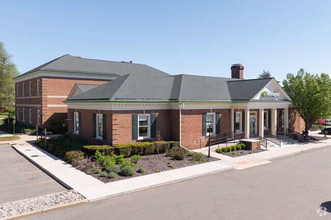
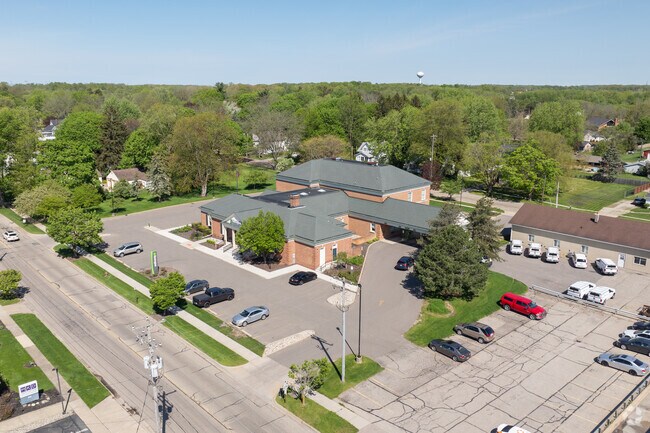
Property Record
627 E Main St Se, Caledonia, MI 49316

Property Detail
627 E Main St Se
41-23-29-427-009
PART SE 1/4 COM 283 FT W ALONG S LINE OF EMMONS ST E /66 FT WIDE/ FROM W LINE OF STL M37 TH W ALONG SD S LINE TO E LINE OF
Financialbuilding
Kent
C1
Michigan
B and X Area of moderate flood hazard, usually the area between the limits of the 100-year and 500-year floods.
1.76 AC
2025
SE Kent County/Caledonia
2025
West Michigan
014810
Grand Rapids-Wyoming-Kentwood, MI
15,996 SF
NEARBY LISTINGS FOR SALE OR LEASE
-
-
View all Caledonia listings for lease on LoopNet.com
DEMOGRAPHICS near 627 E Main St Se
1 mile
3 mile
5 mile
2025 Total Population
2,752
12,451
24,607
2030 Population
2,900
12,997
25,499
Pop Growth 2025-2030
+ 5.38%
+ 4.39%
+ 3.62%
Average Age
37
38
39
2025 Total Households
988
4,179
8,198
HH Growth 2025-2030
+ 5.47%
+ 4.67%
+ 3.83%
Median Household Inc
$109,404
$106,584
$109,838
Avg Household Size
2.80
2.80
2.90
2025 Avg HH Vehicles
2.00
2.00
2.00
Median Home Value
$366,838
$383,395
$389,145
Median Year Built
1998
2000
1997
Nearby Places
Map Layers
Map Styles
 Street
 Aerial
Layers
 Traffic
 Biking
Places
Listings with unknown addresses are not visible on the map
- Restaurants
- Banks
- Shops
- Fitness
- Groceries
PUBLIC TRANSPORTATION
AIRPORT
Gerald R Ford International
Drive
Walk
Distance
Gerald R Ford International
15 min
6.6 mi
SALE & LEASE HISTORY
LISTING DATE
SALE/LEASE

Mar 16, 2023
For Lease
Mar 05, 2019
For Lease
Dec 11, 2017
For Sale
Nearby Properties
Address
Land Use
TOTAL SIZE
Lot Size
Zoning
Address
Land Use
TOTAL SIZE
Lot Size
Zoning
5,744 SF
112.32 AC
MHC
Address
Land Use
TOTAL SIZE
Lot Size
Zoning
8.80 AC
R3
Address
Land Use
TOTAL SIZE
Lot Size
Zoning
40,863 SF
5.33 AC
PUD
Address
Land Use
TOTAL SIZE
Lot Size
Zoning
33,742 SF
6.71 AC
C2
Address
Land Use
TOTAL SIZE
Lot Size
Zoning
36,723 SF
2.86 AC
PUD
Address
Land Use
TOTAL SIZE
Lot Size
Zoning
3,424 SF
120 AC
A
Address
Land Use
TOTAL SIZE
Lot Size
Zoning
36,778 SF
5.72 AC
PUD
Address
Land Use
TOTAL SIZE
Lot Size
Zoning
29,125 SF
2.96 AC
PUD
Address
Land Use
TOTAL SIZE
Lot Size
Zoning
22,931 SF
2.20 AC
PUD
Address
Land Use
TOTAL SIZE
Lot Size
Zoning
36,360 SF
4.35 AC
PUD
Address
Land Use
TOTAL SIZE
Lot Size
Zoning
14,674 SF
2.09 AC
PUD
Address
Land Use
TOTAL SIZE
Lot Size
Zoning
32,290 SF
3.41 AC
PUD
Address
Land Use
TOTAL SIZE
Lot Size
Zoning
41,220 SF
6.08 AC
R3
Address
Land Use
TOTAL SIZE
Lot Size
Zoning
17,312 SF
2.80 AC
PUD
Address
Land Use
TOTAL SIZE
Lot Size
Zoning
11.63 AC
PUD
Address
Land Use
TOTAL SIZE
Lot Size
Zoning
5.28 AC
PUD
Address
Land Use
TOTAL SIZE
Lot Size
Zoning
5.76 AC
PUD
Address
Land Use
TOTAL SIZE
Lot Size
Zoning
4,774 SF
10.60 AC
C2
Address
Land Use
TOTAL SIZE
Lot Size
Zoning
1,825 SF
128.19 AC
A
Address
Land Use
TOTAL SIZE
Lot Size
Zoning
13,682 SF
2.92 AC
PUD
Address
Land Use
TOTAL SIZE
Lot Size
Zoning
2,254 SF
114.24 AC
A
Address
Land Use
TOTAL SIZE
Lot Size
Zoning
77.33 AC
A
Address
Land Use
TOTAL SIZE
Lot Size
Zoning
9,138 SF
2.45 AC
PUD
Address
Land Use
TOTAL SIZE
Lot Size
Zoning
14,010 SF
3.81 AC
PUD
Address
Land Use
TOTAL SIZE
Lot Size
Zoning
4,339 SF
63.28 AC
RR
Address
Land Use
TOTAL SIZE
Lot Size
Zoning
12,840 SF
1.60 AC
PUD
Address
Land Use
TOTAL SIZE
Lot Size
Zoning
9,818 SF
3.36 AC
PUD
Address
Land Use
TOTAL SIZE
Lot Size
Zoning
12,000 SF
1.18 AC
PUD
Address
Land Use
TOTAL SIZE
Lot Size
Zoning
18,000 SF
11.99 AC
PUD
The World's #1 Commercial Real Estate Marketplace
Connect with us
© 2026 CoStar Group
The information above has been obtained from sources believed reliable. While we do not doubt its accuracy we have not verified it and make no guarantee, warranty or representation about it. It is your responsibility to independently confirm its accuracy and completeness. Any projections, opinions, assumptions, or estimates used are for example only and do not represent the current or future performance of the property. The value of this transaction to you depends on tax and other factors which should be evaluated by your tax, financial, and legal advisors. You and your advisors should conduct a careful, independent investigation of the property to determine to your satisfaction the suitability of the property for your needs.