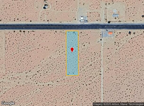
Property Record
62735 Twentynine Palms Hwy, Joshua Tree, CA 92252
NEARBY LISTINGS FOR SALE OR LEASE
Property Detail
62735 Twentynine Palms Hwy
0604-051-13
E 1/2 W 1/2 NW 1/4 NE 1/4 NW 1/4 SEC 31 TP 1N R 7E EX CO RD
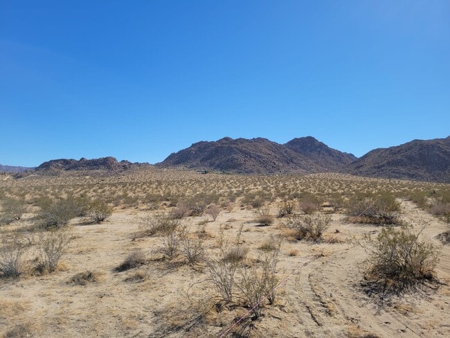
Vacantlandnec
San Bernardino
X
California
06071C8145J
2.32 AC
2024
Twentynine Palms
2025
Inland Empire (California)
010420
Riverside-San Bernardino-Ontario, CA
DEMOGRAPHICS near 62735 Twentynine Palms Hwy
1 Mile
3 Mile
5 Mile
2024 Total Population
3,283
7,605
13,319
2029 Population
3,434
7,975
13,912
Pop Growth 2024-2029
+ 4.60%
+ 4.87%
+ 4.45%
Average Age
42
43
42
2024 Total Households
1,363
3,273
5,551
HH Growth 2024-2029
+ 4.77%
+ 4.89%
+ 4.50%
Median Household Inc
$44,026
$52,835
$54,545
Avg Household Size
2.20
2.20
2.30
2024 Avg HH Vehicles
2.00
2.00
2.00
Median Home Value
$222,916
$350,672
$352,853
Median Year Built
1973
1980
1980
Nearby Places
Map Layers
Map Styles
 Street
 Aerial
- Restaurants
- Banks
- Shops
- Fitness
- Groceries
PUBLIC TRANSPORTATION
AIRPORT
Palm Springs International
DRIVE
WALK
Distance
Palm Springs International
54 min
38.5 mi
Freight Ports
Port of San Diego
DRIVE
WALK
Distance
Port of San Diego
183 min
146.6 mi
SALE & LEASE HISTORY
LISTING DATE
SALE/LEASE

Nov 16, 2021
For Sale
Nearby Properties
Address
Land Use
TOTAL SIZE
Lot Size
Zoning
Address
Land Use
TOTAL SIZE
Lot Size
Zoning
137,595 SF
66.35 AC
Address
Land Use
TOTAL SIZE
Lot Size
Zoning
70,829 SF
4.55 AC
JTRM
Address
Land Use
TOTAL SIZE
Lot Size
Zoning
9,100 SF
1.14 AC
JTCGSCP
Address
Land Use
TOTAL SIZE
Lot Size
Zoning
41,585 SF
4.19 AC
JTRM
Address
Land Use
TOTAL SIZE
Lot Size
Zoning
24,256 SF
0.82 AC
JTRM
Address
Land Use
TOTAL SIZE
Lot Size
Zoning
3,525 SF
13.07 AC
Address
Land Use
TOTAL SIZE
Lot Size
Zoning
11,016 SF
6.76 AC
JTRS14M
Address
Land Use
TOTAL SIZE
Lot Size
Zoning
178,160 SF
4.09 AC
JTRM
Address
Land Use
TOTAL SIZE
Lot Size
Zoning
736 SF
8.22 AC
JTRM
Address
Land Use
TOTAL SIZE
Lot Size
Zoning
5,091 SF
0.61 AC
Address
Land Use
TOTAL SIZE
Lot Size
Zoning
Address
Land Use
TOTAL SIZE
Lot Size
Zoning
4,937 SF
110.45 AC
Address
Land Use
TOTAL SIZE
Lot Size
Zoning
2,690 SF
5 AC
JTRL
Address
Land Use
TOTAL SIZE
Lot Size
Zoning
70,829 SF
2.60 AC
JTRM
Address
Land Use
TOTAL SIZE
Lot Size
Zoning
8,239 SF
1.33 AC
JTRM
Address
Land Use
TOTAL SIZE
Lot Size
Zoning
2,032 SF
2.31 AC
JTRL
Address
Land Use
TOTAL SIZE
Lot Size
Zoning
8,032 SF
0.61 AC
C
Address
Land Use
TOTAL SIZE
Lot Size
Zoning
37.57 AC
JTRM
Address
Land Use
TOTAL SIZE
Lot Size
Zoning
2,141 SF
0.49 AC
JTCGSCP
Address
Land Use
TOTAL SIZE
Lot Size
Zoning
4,494 SF
0.89 AC
C1
Address
Land Use
TOTAL SIZE
Lot Size
Zoning
6,957 SF
0.34 AC
JTCGSCP
Address
Land Use
TOTAL SIZE
Lot Size
Zoning
3,010 SF
0.61 AC
JTCGSCP
Address
Land Use
TOTAL SIZE
Lot Size
Zoning
2,128 SF
1 AC
JTCGSCP
Address
Land Use
TOTAL SIZE
Lot Size
Zoning
5,963 SF
0.89 AC
JTCGSCP
Address
Land Use
TOTAL SIZE
Lot Size
Zoning
16,320 SF
2.64 AC
JTCGSCP
Address
Land Use
TOTAL SIZE
Lot Size
Zoning
7,000 SF
0.67 AC
JTCGSCP
Address
Land Use
TOTAL SIZE
Lot Size
Zoning
39.62 AC
JTRL
Address
Land Use
TOTAL SIZE
Lot Size
Zoning
1,917 SF
0.22 AC
JTCGSCP
Address
Land Use
TOTAL SIZE
Lot Size
Zoning
36.22 AC
JTRS10M
The World's #1 Commercial Real Estate Marketplace
Connect with us
© 2025 CoStar Group
The information above has been obtained from sources believed reliable. While we do not doubt its accuracy we have not verified it and make no guarantee, warranty or representation about it. It is your responsibility to independently confirm its accuracy and completeness. Any projections, opinions, assumptions, or estimates used are for example only and do not represent the current or future performance of the property. The value of this transaction to you depends on tax and other factors which should be evaluated by your tax, financial, and legal advisors. You and your advisors should conduct a careful, independent investigation of the property to determine to your satisfaction the suitability of the property for your needs.