Property Record
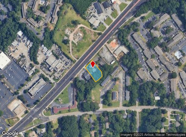
6277 Memorial Dr, Stone Mountain, GA 30083
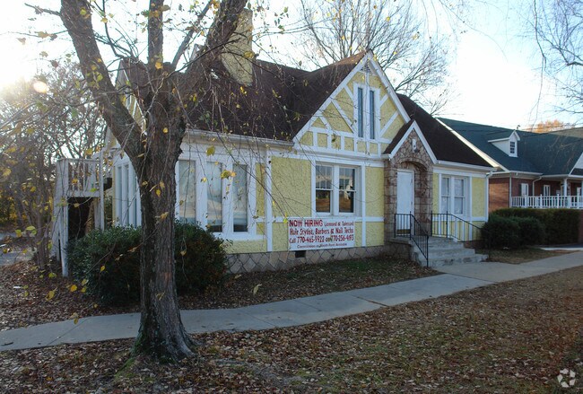

This Property Is For Sale
NEARBY LISTINGS FOR SALE OR LEASE
Property Detail
6277 Memorial Dr
18-091-04-009
TRACT 13-JAN-06 .46AC 104 X 161 X 50 X 50 X 35 X 187
Storebuilding
DeKalb
X
Georgia
13089C0091K
91
2025
0.46 AC
2025
Stone Mountain
021914
Atlanta
3,057 SF
Atlanta-Sandy Springs-Roswell, GA
DEMOGRAPHICS near 6277 Memorial Dr
1 Mile
3 Mile
5 Mile
2024 Total Population
16,429
78,752
218,345
2029 Population
16,640
78,645
218,699
Pop Growth 2024-2029
+ 1.28%
(0.14%)
+ 0.16%
Average Age
35
38
38
2024 Total Households
6,425
28,553
80,512
HH Growth 2024-2029
+ 1.39%
(0.12%)
+ 0.19%
Median Household Inc
$38,408
$53,147
$60,905
Avg Household Size
2.50
2.70
2.60
2024 Avg HH Vehicles
1.00
2.00
2.00
Median Home Value
$215,794
$226,446
$256,392
Median Year Built
1977
1978
1979
Nearby Places
- Restaurants
- Banks
- Shops
- Fitness
- Groceries
PUBLIC TRANSPORTATION
AIRPORT
Hartsfield - Jackson Atlanta International
DRIVE
WALK
Distance
Hartsfield - Jackson Atlanta International
35 min
22.9 mi
Nearby Properties
Address
Land Use
TOTAL SIZE
Lot Size
Zoning
Address
Land Use
TOTAL SIZE
Lot Size
Zoning
656,837 SF
88.74 AC
RM100
Address
Land Use
TOTAL SIZE
Lot Size
Zoning
819,703 SF
55.80 AC
M
Address
Land Use
TOTAL SIZE
Lot Size
Zoning
587,493 SF
29.79 AC
X
Address
Land Use
TOTAL SIZE
Lot Size
Zoning
337,746 SF
29.94 AC
RM100
Address
Land Use
TOTAL SIZE
Lot Size
Zoning
339,262 SF
26.16 AC
RM100
Address
Land Use
TOTAL SIZE
Lot Size
Zoning
224,812 SF
19.29 AC
RM75
Address
Land Use
TOTAL SIZE
Lot Size
Zoning
269,639 SF
24.65 AC
RM100
Address
Land Use
TOTAL SIZE
Lot Size
Zoning
480,302 SF
34.46 AC
RM85
Address
Land Use
TOTAL SIZE
Lot Size
Zoning
358,818 SF
22.41 AC
RM100
Address
Land Use
TOTAL SIZE
Lot Size
Zoning
446,287 SF
31 AC
RM100
Address
Land Use
TOTAL SIZE
Lot Size
Zoning
249,184 SF
20 AC
RM100
Address
Land Use
TOTAL SIZE
Lot Size
Zoning
240,276 SF
19.53 AC
RM85
Address
Land Use
TOTAL SIZE
Lot Size
Zoning
302,988 SF
41.36 AC
X
Address
Land Use
TOTAL SIZE
Lot Size
Zoning
292,996 SF
15.84 AC
RM100
Address
Land Use
TOTAL SIZE
Lot Size
Zoning
373,062 SF
20.59 AC
RM100
Address
Land Use
TOTAL SIZE
Lot Size
Zoning
324,116 SF
19.90 AC
A
Address
Land Use
TOTAL SIZE
Lot Size
Zoning
312,258 SF
24.80 AC
X
Address
Land Use
TOTAL SIZE
Lot Size
Zoning
384,545 SF
35.93 AC
RM100
Address
Land Use
TOTAL SIZE
Lot Size
Zoning
273,192 SF
24.07 AC
RM100
Address
Land Use
TOTAL SIZE
Lot Size
Zoning
189,486 SF
18.57 AC
X
Address
Land Use
TOTAL SIZE
Lot Size
Zoning
490,343 SF
28.70 AC
X
Address
Land Use
TOTAL SIZE
Lot Size
Zoning
124,868 SF
14.82 AC
Address
Land Use
TOTAL SIZE
Lot Size
Zoning
285,494 SF
19.35 AC
Address
Land Use
TOTAL SIZE
Lot Size
Zoning
495,922 SF
30.90 AC
RM100
Address
Land Use
TOTAL SIZE
Lot Size
Zoning
279,568 SF
0.15 AC
X
Address
Land Use
TOTAL SIZE
Lot Size
Zoning
223,756 SF
18.34 AC
RM85
Address
Land Use
TOTAL SIZE
Lot Size
Zoning
244,898 SF
15 AC
RM85
Address
Land Use
TOTAL SIZE
Lot Size
Zoning
331,031 SF
27.34 AC
RM100
Address
Land Use
TOTAL SIZE
Lot Size
Zoning
232,418 SF
21.57 AC
RM100
Address
Land Use
TOTAL SIZE
Lot Size
Zoning
34,138 SF
10.97 AC
MR1
The World's #1 Commercial Real Estate Marketplace
Connect with us
© 2025 CoStar Group
The information above has been obtained from sources believed reliable. While we do not doubt its accuracy we have not verified it and make no guarantee, warranty or representation about it. It is your responsibility to independently confirm its accuracy and completeness. Any projections, opinions, assumptions, or estimates used are for example only and do not represent the current or future performance of the property. The value of this transaction to you depends on tax and other factors which should be evaluated by your tax, financial, and legal advisors. You and your advisors should conduct a careful, independent investigation of the property to determine to your satisfaction the suitability of the property for your needs.