Property Record
6285 Jubal Early Hwy, Hardy, VA 24101

NEARBY LISTINGS FOR SALE OR LEASE
-
-
View all Hardy listings for sale on LoopNet.com
Property Detail
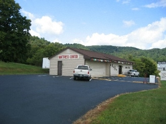
6285 Jubal Early Hwy
0100003400
RT 116-JUBAL EARLY HIGHWAY
Storebuilding
Franklin
X
Virginia
51019C0425D
0.60 AC
2025
North Franklin County
2025
Roanoke
020301
Roanoke, VA
3,744 SF
DEMOGRAPHICS near 6285 Jubal Early Hwy
1 Mile
3 Mile
5 Mile
2024 Total Population
279
2,196
10,470
2029 Population
281
2,211
10,494
Pop Growth 2024-2029
+ 0.72%
+ 0.68%
+ 0.23%
Average Age
44
44
44
2024 Total Households
112
887
4,347
HH Growth 2024-2029
+ 0.89%
+ 0.45%
+ 0.09%
Median Household Inc
$68,749
$63,979
$57,760
Avg Household Size
2.50
2.40
2.40
2024 Avg HH Vehicles
2.00
2.00
2.00
Median Home Value
$209,375
$211,656
$217,008
Median Year Built
1986
1983
1978
Nearby Places
- Restaurants
- Banks
- Shops
- Fitness
- Groceries
PUBLIC TRANSPORTATION
COMMUTER RAIL
Roanoke (Northeast Regional - Amtrak)
DRIVE
WALK
Distance
Roanoke (Northeast Regional - Amtrak)
15 min
9.8 mi
AIRPORT
Roanoke/Blacksburg Regional (Woodrum Field)
DRIVE
WALK
Distance
Roanoke/Blacksburg Regional (Woodrum Field)
25 min
14.7 mi
Freight Ports
Virginia Port Authority - Richmond
DRIVE
WALK
Distance
Virginia Port Authority - Richmond
226 min
166.7 mi
Nearby Properties
Address
Land Use
TOTAL SIZE
Lot Size
Zoning
Address
Land Use
TOTAL SIZE
Lot Size
Zoning
48,908 SF
30.09 AC
A1
Address
Land Use
TOTAL SIZE
Lot Size
Zoning
3,968 SF
2.50 AC
R3
Address
Land Use
TOTAL SIZE
Lot Size
Zoning
7,451 SF
3.60 AC
AG1
Address
Land Use
TOTAL SIZE
Lot Size
Zoning
7,868 SF
1.78 AC
A1
Address
Land Use
TOTAL SIZE
Lot Size
Zoning
11,640 SF
33.12 AC
I2
Address
Land Use
TOTAL SIZE
Lot Size
Zoning
286.14 AC
A1
Address
Land Use
TOTAL SIZE
Lot Size
Zoning
20.21 AC
A1
Address
Land Use
TOTAL SIZE
Lot Size
Zoning
3,880 SF
0.63 AC
B2
Address
Land Use
TOTAL SIZE
Lot Size
Zoning
5,280 SF
61.60 AC
I2
Address
Land Use
TOTAL SIZE
Lot Size
Zoning
2,720 SF
8.79 AC
A1
Address
Land Use
TOTAL SIZE
Lot Size
Zoning
38.06 AC
SM
Address
Land Use
TOTAL SIZE
Lot Size
Zoning
5,768 SF
10.56 AC
B2
Address
Land Use
TOTAL SIZE
Lot Size
Zoning
2,112 SF
1.50 AC
A1
Address
Land Use
TOTAL SIZE
Lot Size
Zoning
71.22 AC
A1
Address
Land Use
TOTAL SIZE
Lot Size
Zoning
130 AC
A1
Address
Land Use
TOTAL SIZE
Lot Size
Zoning
76.41 AC
A1
Address
Land Use
TOTAL SIZE
Lot Size
Zoning
72 AC
A1
Address
Land Use
TOTAL SIZE
Lot Size
Zoning
91.68 AC
Address
Land Use
TOTAL SIZE
Lot Size
Zoning
66.02 AC
A1
Address
Land Use
TOTAL SIZE
Lot Size
Zoning
1,988 SF
42.15 AC
A1
Address
Land Use
TOTAL SIZE
Lot Size
Zoning
845 SF
80 AC
A1
Address
Land Use
TOTAL SIZE
Lot Size
Zoning
1,275 SF
75 AC
A1
Address
Land Use
TOTAL SIZE
Lot Size
Zoning
83 AC
A1
Address
Land Use
TOTAL SIZE
Lot Size
Zoning
1.27 AC
A1
Address
Land Use
TOTAL SIZE
Lot Size
Zoning
51.36 AC
AG3
Address
Land Use
TOTAL SIZE
Lot Size
Zoning
54.66 AC
AG3
Address
Land Use
TOTAL SIZE
Lot Size
Zoning
39.39 AC
A1
Address
Land Use
TOTAL SIZE
Lot Size
Zoning
36.59 AC
AG3
Address
Land Use
TOTAL SIZE
Lot Size
Zoning
2,552 SF
0.69 AC
B2
The World's #1 Commercial Real Estate Marketplace
Connect with us
© 2025 CoStar Group
The information above has been obtained from sources believed reliable. While we do not doubt its accuracy we have not verified it and make no guarantee, warranty or representation about it. It is your responsibility to independently confirm its accuracy and completeness. Any projections, opinions, assumptions, or estimates used are for example only and do not represent the current or future performance of the property. The value of this transaction to you depends on tax and other factors which should be evaluated by your tax, financial, and legal advisors. You and your advisors should conduct a careful, independent investigation of the property to determine to your satisfaction the suitability of the property for your needs.