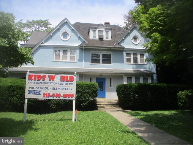
Property Record
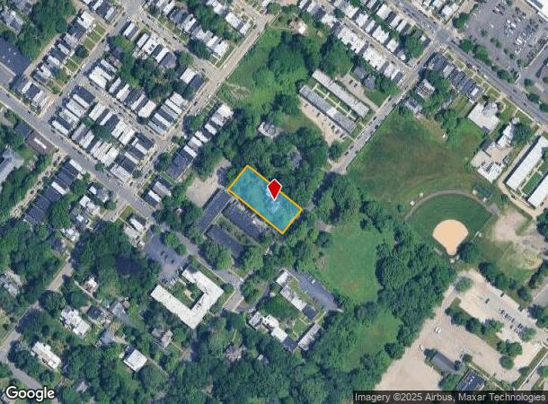
629 E Church Ln, Philadelphia, PA 19144
Current Lease Availabilities
NEARBY LISTINGS FOR SALE OR LEASE
Property Detail
629 E Church Ln
776121100
20510 1/2E MUSGRAVE
Religious
Philadelphia
X
Pennsylvania
42091C0395G
129
2023
0.53 AC
2026
Northwest Philadelphia
024700
Philadelphia
6,364 SF
Philadelphia-Camden-Wilmington, PA-NJ-DE-MD
DEMOGRAPHICS near 629 E Church Ln
1 Mile
3 Mile
5 Mile
2024 Total Population
44,733
322,402
784,649
2029 Population
43,474
312,607
767,622
Pop Growth 2024-2029
(2.81%)
(3.04%)
(2.17%)
Average Age
38
40
38
2024 Total Households
17,019
131,715
309,394
HH Growth 2024-2029
(3.31%)
(3.15%)
(2.25%)
Median Household Inc
$33,060
$48,135
$49,908
Avg Household Size
2.40
2.30
2.40
2024 Avg HH Vehicles
1.00
1.00
1.00
Median Home Value
$141,717
$183,265
$212,169
Median Year Built
1947
1948
1949
Nearby Places
- Restaurants
- Banks
- Shops
- Fitness
- Groceries
PUBLIC TRANSPORTATION
TRANSIT/SUBWAY
Wister (R7 - Southeastern Pennsylvania Transportation Authority Regional Rail (SEPTA Regional Rail))
DRIVE
WALK
Distance
Wister (R7 - Southeastern Pennsylvania Transportation Authority Regional Rail (SEPTA Regional Rail))
4 min
12 min
0.6 mi
Germantown (R7 - Southeastern Pennsylvania Transportation Authority Regional Rail (SEPTA Regional Rail))
DRIVE
WALK
Distance
Germantown (R7 - Southeastern Pennsylvania Transportation Authority Regional Rail (SEPTA Regional Rail))
4 min
16 min
0.8 mi
Washington Lane (R7 - Southeastern Pennsylvania Transportation Authority Regional Rail (SEPTA Regional Rail))
DRIVE
WALK
Distance
Washington Lane (R7 - Southeastern Pennsylvania Transportation Authority Regional Rail (SEPTA Regional Rail))
4 min
19 min
1.0 mi
COMMUTER RAIL
Wister (R7 - Southeastern Pennsylvania Transportation Authority Regional Rail (SEPTA Regional Rail))
DRIVE
WALK
Distance
Wister (R7 - Southeastern Pennsylvania Transportation Authority Regional Rail (SEPTA Regional Rail))
4 min
12 min
0.6 mi
Germantown (R7 - Southeastern Pennsylvania Transportation Authority Regional Rail (SEPTA Regional Rail))
DRIVE
WALK
Distance
Germantown (R7 - Southeastern Pennsylvania Transportation Authority Regional Rail (SEPTA Regional Rail))
4 min
16 min
0.8 mi
AIRPORT
Philadelphia International
DRIVE
WALK
Distance
Philadelphia International
34 min
17.7 mi
Trenton Mercer
DRIVE
WALK
Distance
Trenton Mercer
52 min
30.2 mi
Freight Ports
Port of Philadelphia
DRIVE
WALK
Distance
Port of Philadelphia
18 min
7.9 mi
Nearby Properties
Address
Land Use
TOTAL SIZE
Lot Size
Zoning
Address
Land Use
TOTAL SIZE
Lot Size
Zoning
638,776 SF
20 AC
RM2
Address
Land Use
TOTAL SIZE
Lot Size
Zoning
455,889 SF
33 AC
I2
Address
Land Use
TOTAL SIZE
Lot Size
Zoning
520,280 SF
14.84 AC
RM3
Address
Land Use
TOTAL SIZE
Lot Size
Zoning
2,146,150 SF
119.95 AC
M1
Address
Land Use
TOTAL SIZE
Lot Size
Zoning
22,648 SF
38.69 AC
RM3
Address
Land Use
TOTAL SIZE
Lot Size
Zoning
485,616 SF
8.96 AC
CMX3
Address
Land Use
TOTAL SIZE
Lot Size
Zoning
242,655 SF
3.29 AC
CMX3
Address
Land Use
TOTAL SIZE
Lot Size
Zoning
425,535 SF
4.60 AC
RM3
Address
Land Use
TOTAL SIZE
Lot Size
Zoning
3,590 SF
50 AC
SPPOA
Address
Land Use
TOTAL SIZE
Lot Size
Zoning
121,578 SF
3.13 AC
RSA3
Address
Land Use
TOTAL SIZE
Lot Size
Zoning
587,330 SF
34.37 AC
SPINS
Address
Land Use
TOTAL SIZE
Lot Size
Zoning
287,286 SF
1.26 AC
CMX5
Address
Land Use
TOTAL SIZE
Lot Size
Zoning
17,886 SF
80 AC
SPPOA
Address
Land Use
TOTAL SIZE
Lot Size
Zoning
495,017 SF
9.65 AC
CMX3
Address
Land Use
TOTAL SIZE
Lot Size
Zoning
504,972 SF
16.30 AC
RM2
Address
Land Use
TOTAL SIZE
Lot Size
Zoning
500,000 SF
2.30 AC
CMX3
Address
Land Use
TOTAL SIZE
Lot Size
Zoning
218,030 SF
23.75 AC
CA2
Address
Land Use
TOTAL SIZE
Lot Size
Zoning
180,750 SF
1.60 AC
CMX3
Address
Land Use
TOTAL SIZE
Lot Size
Zoning
238,378 SF
18 AC
CA1
Address
Land Use
TOTAL SIZE
Lot Size
Zoning
293,734 SF
4.42 AC
ICMX
Address
Land Use
TOTAL SIZE
Lot Size
Zoning
75,358 SF
24.98 AC
I2
Address
Land Use
TOTAL SIZE
Lot Size
Zoning
237,834 SF
0.96 AC
CMX3
Address
Land Use
TOTAL SIZE
Lot Size
Zoning
300 AC
RSD1
Address
Land Use
TOTAL SIZE
Lot Size
Zoning
249,388 SF
8.08 AC
RSA5
Address
Land Use
TOTAL SIZE
Lot Size
Zoning
363,136 SF
16.47 AC
RSA3
Address
Land Use
TOTAL SIZE
Lot Size
Zoning
233,143 SF
24.24 AC
SPINS
Address
Land Use
TOTAL SIZE
Lot Size
Zoning
170,842 SF
16.51 AC
RSD1
Address
Land Use
TOTAL SIZE
Lot Size
Zoning
180,000 SF
13.30 AC
CMX3
Address
Land Use
TOTAL SIZE
Lot Size
Zoning
329,300 SF
6.98 AC
RSA5
Address
Land Use
TOTAL SIZE
Lot Size
Zoning
356,056 SF
1.91 AC
CMX3
The World's #1 Commercial Real Estate Marketplace
Connect with us
© 2025 CoStar Group
The information above has been obtained from sources believed reliable. While we do not doubt its accuracy we have not verified it and make no guarantee, warranty or representation about it. It is your responsibility to independently confirm its accuracy and completeness. Any projections, opinions, assumptions, or estimates used are for example only and do not represent the current or future performance of the property. The value of this transaction to you depends on tax and other factors which should be evaluated by your tax, financial, and legal advisors. You and your advisors should conduct a careful, independent investigation of the property to determine to your satisfaction the suitability of the property for your needs.