Property Record
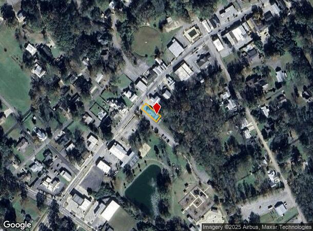
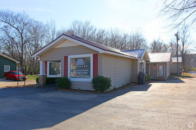
6290 Us Highway 11, Springville, AL 35146

NEARBY LISTINGS FOR SALE OR LEASE
Property Detail
6290 Us Highway 11
13-09-31-0-011-017.004
BEG INT NE RW OLD TALLADEGA RD W/SE RW US HWY #11, TH NE ALG HWY 41', SE 125', SW 41' TO NE RW SD RD, NW ALG RD 125' TO POB:
Realpropertynec
St Clair
X
Alabama
01009C0500F
0.12 AC
2024
St Clair County
2024
Birmingham
040503
Birmingham-Hoover, AL
2,648 SF
DEMOGRAPHICS near 6290 Us Highway 11
1 Mile
3 Mile
5 Mile
2024 Total Population
2,013
6,250
12,278
2029 Population
2,141
6,665
13,173
Pop Growth 2024-2029
+ 6.36%
+ 6.64%
+ 7.29%
Average Age
42
42
41
2024 Total Households
758
2,319
4,490
HH Growth 2024-2029
+ 6.07%
+ 6.43%
+ 7.08%
Median Household Inc
$93,571
$84,414
$75,196
Avg Household Size
2.60
2.70
2.70
2024 Avg HH Vehicles
2.00
2.00
2.00
Median Home Value
$310,714
$289,486
$238,011
Median Year Built
2000
1999
2000
Nearby Places
Map Layers
Map Styles
 Street
 Aerial
- Restaurants
- Banks
- Shops
- Fitness
- Groceries
PUBLIC TRANSPORTATION
AIRPORT
Birmingham-Shuttlesworth International
DRIVE
WALK
Distance
Birmingham-Shuttlesworth International
31 min
25.6 mi
Freight Ports
Port of Mobile
DRIVE
WALK
Distance
Port of Mobile
306 min
280.9 mi
Nearby Properties
Address
Land Use
TOTAL SIZE
Lot Size
Zoning
Address
Land Use
TOTAL SIZE
Lot Size
Zoning
91,680 SF
8.60 AC
Address
Land Use
TOTAL SIZE
Lot Size
Zoning
Address
Land Use
TOTAL SIZE
Lot Size
Zoning
4,650 SF
4.17 AC
Address
Land Use
TOTAL SIZE
Lot Size
Zoning
7,538 SF
1.25 AC
Address
Land Use
TOTAL SIZE
Lot Size
Zoning
16,996 SF
3.10 AC
Address
Land Use
TOTAL SIZE
Lot Size
Zoning
2,760 SF
7.50 AC
Address
Land Use
TOTAL SIZE
Lot Size
Zoning
5,190 SF
9.60 AC
Address
Land Use
TOTAL SIZE
Lot Size
Zoning
6,988 SF
1 AC
Address
Land Use
TOTAL SIZE
Lot Size
Zoning
3,453 SF
1.12 AC
Address
Land Use
TOTAL SIZE
Lot Size
Zoning
12,600 SF
0.36 AC
Address
Land Use
TOTAL SIZE
Lot Size
Zoning
1,136 SF
8.40 AC
Address
Land Use
TOTAL SIZE
Lot Size
Zoning
5,395 SF
1.66 AC
Address
Land Use
TOTAL SIZE
Lot Size
Zoning
33,136 SF
3 AC
Address
Land Use
TOTAL SIZE
Lot Size
Zoning
11.13 AC
Address
Land Use
TOTAL SIZE
Lot Size
Zoning
2,942 SF
0.89 AC
Address
Land Use
TOTAL SIZE
Lot Size
Zoning
3,911 SF
1.10 AC
Address
Land Use
TOTAL SIZE
Lot Size
Zoning
5,628 SF
1.30 AC
Address
Land Use
TOTAL SIZE
Lot Size
Zoning
7,083 SF
0.96 AC
Address
Land Use
TOTAL SIZE
Lot Size
Zoning
4,872 SF
1.03 AC
Address
Land Use
TOTAL SIZE
Lot Size
Zoning
3,111 SF
0.88 AC
Address
Land Use
TOTAL SIZE
Lot Size
Zoning
4,266 SF
95 AC
Address
Land Use
TOTAL SIZE
Lot Size
Zoning
3,329 SF
0.70 AC
Address
Land Use
TOTAL SIZE
Lot Size
Zoning
3,902 SF
2.58 AC
Address
Land Use
TOTAL SIZE
Lot Size
Zoning
4,751 SF
0.71 AC
Address
Land Use
TOTAL SIZE
Lot Size
Zoning
3,000 SF
0.65 AC
The World's #1 Commercial Real Estate Marketplace
Connect with us
© 2025 CoStar Group
The information above has been obtained from sources believed reliable. While we do not doubt its accuracy we have not verified it and make no guarantee, warranty or representation about it. It is your responsibility to independently confirm its accuracy and completeness. Any projections, opinions, assumptions, or estimates used are for example only and do not represent the current or future performance of the property. The value of this transaction to you depends on tax and other factors which should be evaluated by your tax, financial, and legal advisors. You and your advisors should conduct a careful, independent investigation of the property to determine to your satisfaction the suitability of the property for your needs.