Property Record
6292 Walmore Rd, Niagara Falls, NY 14304
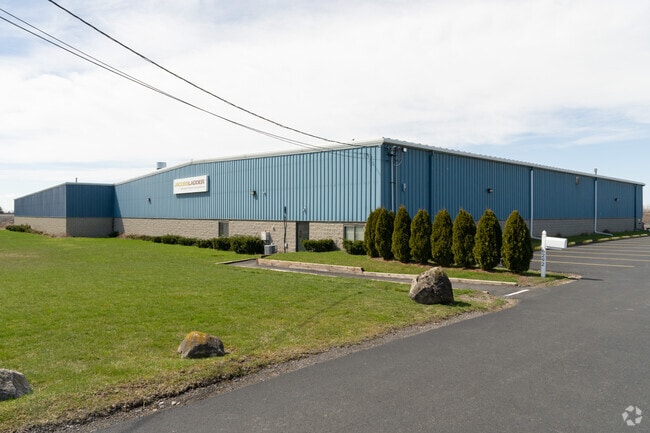


Property Detail
6292 Walmore Rd
Buffalo-Cheektowaga, NY
12/94 11997 155,000
294000-146-000-0001-007-012
NIAGARA
Industrialgeneral
New York
AE The base floodplain where base flood elevations are provided. AE Zones are now used on new format FIRMs instead of A1-A30 Zones.
7.012
2025
9.60 AC
2025
Outlying Niagara County
022715
Buffalo/Niagara Falls
34,816 SF
NEARBY LISTINGS FOR SALE OR LEASE
DEMOGRAPHICS near 6292 Walmore Rd
1 mile
3 mile
5 mile
2025 Total Population
183
19,082
51,136
2030 Population
177
18,878
50,691
Pop Growth 2025-2030
(3.28%)
(1.07%)
(0.87%)
Average Age
46
45
44
2025 Total Households
70
8,447
22,195
HH Growth 2025-2030
(2.86%)
(1.11%)
(0.93%)
Median Household Inc
$80,357
$68,935
$71,859
Avg Household Size
2.40
2.20
2.20
2025 Avg HH Vehicles
2.00
2.00
2.00
Median Home Value
$230,357
$192,908
$188,021
Median Year Built
1962
1970
1960
Nearby Places
Map Layers
Map Styles
 Street
 Aerial
Layers
 Traffic
 Biking
Places
Listings with unknown addresses are not visible on the map
- Restaurants
- Banks
- Shops
- Fitness
- Groceries
PUBLIC TRANSPORTATION
COMMUTER RAIL
Drive
Walk
Distance
16 min
7.4 mi
AIRPORT
Niagara Falls International
Drive
Walk
Distance
Niagara Falls International
6 min
2.4 mi
Buffalo Niagara International
Drive
Walk
Distance
Buffalo Niagara International
35 min
18.9 mi
SALE & LEASE HISTORY
LISTING DATE
SALE/LEASE

Mar 14, 2024
For Sale
Nearby Properties
Address
Land Use
TOTAL SIZE
Lot Size
Zoning
Address
Land Use
TOTAL SIZE
Lot Size
Zoning
160.52 AC
06 - INDUS
Address
Land Use
TOTAL SIZE
Lot Size
Zoning
37.85 AC
06 - INDUS
Address
Land Use
TOTAL SIZE
Lot Size
Zoning
181,549 SF
81.90 AC
Address
Land Use
TOTAL SIZE
Lot Size
Zoning
131,846 SF
14.66 AC
05 - COMME
Address
Land Use
TOTAL SIZE
Lot Size
Zoning
200.67 AC
06 - INDUS
Address
Land Use
TOTAL SIZE
Lot Size
Zoning
1,200 SF
49.80 AC
05 - COMME
Address
Land Use
TOTAL SIZE
Lot Size
Zoning
1,600 SF
34.80 AC
06 - INDUS
Address
Land Use
TOTAL SIZE
Lot Size
Zoning
110,174 SF
20.92 AC
05 - COMME
Address
Land Use
TOTAL SIZE
Lot Size
Zoning
11,788 SF
13.91 AC
03 - MULTI
Address
Land Use
TOTAL SIZE
Lot Size
Zoning
5,674 SF
0.06 AC
05 - COMME
Address
Land Use
TOTAL SIZE
Lot Size
Zoning
10,647 SF
14 AC
C3
Address
Land Use
TOTAL SIZE
Lot Size
Zoning
720 SF
19.45 AC
05 - COMME
Address
Land Use
TOTAL SIZE
Lot Size
Zoning
4,004 SF
9.25 AC
03 - MULTI
Address
Land Use
TOTAL SIZE
Lot Size
Zoning
26,024 SF
3.30 AC
05 - COMME
Address
Land Use
TOTAL SIZE
Lot Size
Zoning
6,369 SF
12.58 AC
C3
Address
Land Use
TOTAL SIZE
Lot Size
Zoning
82,528 SF
3 AC
Address
Land Use
TOTAL SIZE
Lot Size
Zoning
6,289 SF
19.08 AC
05 - COMME
Address
Land Use
TOTAL SIZE
Lot Size
Zoning
3,204 SF
1.55 AC
05 - COMME
Address
Land Use
TOTAL SIZE
Lot Size
Zoning
65,623 SF
12.05 AC
Address
Land Use
TOTAL SIZE
Lot Size
Zoning
25,080 SF
3.03 AC
01 - NOT Z
Address
Land Use
TOTAL SIZE
Lot Size
Zoning
25,422 SF
5.14 AC
02 - SINGL
Address
Land Use
TOTAL SIZE
Lot Size
Zoning
36,000 SF
8.40 AC
Address
Land Use
TOTAL SIZE
Lot Size
Zoning
47,895 SF
3.53 AC
01 - NOT Z
Address
Land Use
TOTAL SIZE
Lot Size
Zoning
Address
Land Use
TOTAL SIZE
Lot Size
Zoning
87,039 SF
13.10 AC
Address
Land Use
TOTAL SIZE
Lot Size
Zoning
47,716 SF
2 AC
Address
Land Use
TOTAL SIZE
Lot Size
Zoning
17,480 SF
324.45 AC
06 - INDUS
Address
Land Use
TOTAL SIZE
Lot Size
Zoning
16,891 SF
6.68 AC
01 - NOT Z
Address
Land Use
TOTAL SIZE
Lot Size
Zoning
27,140 SF
2.74 AC
05 - COMME
Address
Land Use
TOTAL SIZE
Lot Size
Zoning
24,449 SF
4.26 AC
05 - COMME
The World's #1 Commercial Real Estate Marketplace
Connect with us
© 2026 CoStar Group
The information above has been obtained from sources believed reliable. While we do not doubt its accuracy we have not verified it and make no guarantee, warranty or representation about it. It is your responsibility to independently confirm its accuracy and completeness. Any projections, opinions, assumptions, or estimates used are for example only and do not represent the current or future performance of the property. The value of this transaction to you depends on tax and other factors which should be evaluated by your tax, financial, and legal advisors. You and your advisors should conduct a careful, independent investigation of the property to determine to your satisfaction the suitability of the property for your needs.