Property Record
6298 E Springfield Ave, Fowler, CA 93625
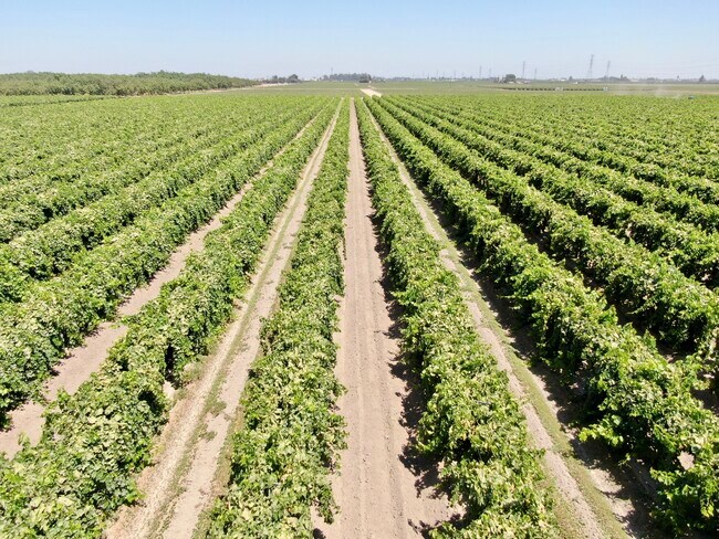

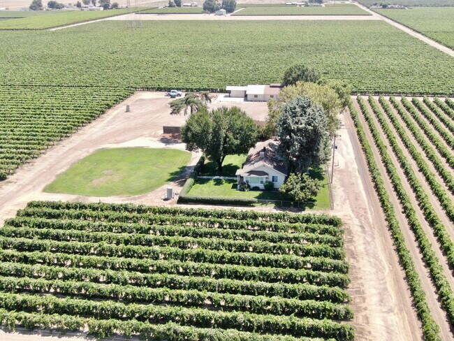
Property Detail
6298 E Springfield Ave
348-030-12
40 ACS IN SE 1/4 NW 1/4 SEC 27 T15R21
Orchard
FRESNO
AE20
California
B and X Area of moderate flood hazard, usually the area between the limits of the 100-year and 500-year floods.
40 AC
2025
W Outlying Fresno County
2025
Fresno
001600
Fresno, CA
NEARBY LISTINGS FOR SALE OR LEASE
-
-
View all Fowler listings for sale on LoopNet.com
DEMOGRAPHICS near 6298 E Springfield Ave
1 mile
3 mile
5 mile
2025 Total Population
227
12,161
39,457
2030 Population
218
12,378
39,909
Pop Growth 2025-2030
(3.96%)
+ 1.78%
+ 1.15%
Average Age
39
37
36
2025 Total Households
70
3,546
11,408
HH Growth 2025-2030
(4.29%)
+ 1.78%
+ 1.09%
Median Household Inc
$78,571
$63,761
$58,199
Avg Household Size
3.20
3.40
3.40
2025 Avg HH Vehicles
2.00
2.00
2.00
Median Home Value
$625,000
$387,300
$360,567
Median Year Built
1969
1986
1979
Nearby Places
Map Layers
Map Styles
 Street
 Aerial
Transit
 Traffic
 Biking
Places
Listings with unknown addresses are not visible on the map
- Restaurants
- Banks
- Shops
- Fitness
- Groceries
PUBLIC TRANSPORTATION
AIRPORT
Fresno Yosemite International
Drive
Walk
Distance
Fresno Yosemite International
24 min
14.0 mi
Freight Ports
Port of Stockton
Drive
Walk
Distance
Port of Stockton
165 min
139.1 mi
SALE & LEASE HISTORY
LISTING DATE
SALE/LEASE

Aug 06, 2020
For Sale
Nearby Properties
Address
Land Use
TOTAL SIZE
Lot Size
Zoning
Address
Land Use
TOTAL SIZE
Lot Size
Zoning
725,468 SF
25 AC
MI
Address
Land Use
TOTAL SIZE
Lot Size
Zoning
242,970 SF
30.43 AC
Address
Land Use
TOTAL SIZE
Lot Size
Zoning
270,292 SF
23.86 AC
M1
Address
Land Use
TOTAL SIZE
Lot Size
Zoning
272,338 SF
25.80 AC
M2
Address
Land Use
TOTAL SIZE
Lot Size
Zoning
104,516 SF
11.30 AC
C3*TWR
Address
Land Use
TOTAL SIZE
Lot Size
Zoning
106,112 SF
12.78 AC
AE20
Address
Land Use
TOTAL SIZE
Lot Size
Zoning
166,390 SF
32.58 AC
M3
Address
Land Use
TOTAL SIZE
Lot Size
Zoning
52,725 SF
2.04 AC
CR
Address
Land Use
TOTAL SIZE
Lot Size
Zoning
48,639 SF
6.50 AC
CR
Address
Land Use
TOTAL SIZE
Lot Size
Zoning
140,609 SF
84.02 AC
M2
Address
Land Use
TOTAL SIZE
Lot Size
Zoning
67,162 SF
3.91 AC
RM3
Address
Land Use
TOTAL SIZE
Lot Size
Zoning
195,223 SF
10.66 AC
M3
Address
Land Use
TOTAL SIZE
Lot Size
Zoning
127,130 SF
9.78 AC
AE20
Address
Land Use
TOTAL SIZE
Lot Size
Zoning
246,464 SF
39.73 AC
M3
Address
Land Use
TOTAL SIZE
Lot Size
Zoning
41,400 SF
0.97 AC
CH
Address
Land Use
TOTAL SIZE
Lot Size
Zoning
62,534 SF
12.45 AC
C3
Address
Land Use
TOTAL SIZE
Lot Size
Zoning
2,131 SF
148.88 AC
AE20
Address
Land Use
TOTAL SIZE
Lot Size
Zoning
172,176 SF
12.11 AC
M3
Address
Land Use
TOTAL SIZE
Lot Size
Zoning
113,481 SF
14.56 AC
M1
Address
Land Use
TOTAL SIZE
Lot Size
Zoning
698,000 SF
4.32 AC
M2
Address
Land Use
TOTAL SIZE
Lot Size
Zoning
103.71 AC
AE20
Address
Land Use
TOTAL SIZE
Lot Size
Zoning
4,310 SF
1.14 AC
CK
Address
Land Use
TOTAL SIZE
Lot Size
Zoning
54,806 SF
5.41 AC
C2TWR
Address
Land Use
TOTAL SIZE
Lot Size
Zoning
58,200 SF
7.02 AC
M1
Address
Land Use
TOTAL SIZE
Lot Size
Zoning
16,240 SF
2.57 AC
M3
Address
Land Use
TOTAL SIZE
Lot Size
Zoning
56,376 SF
4.46 AC
R3
Address
Land Use
TOTAL SIZE
Lot Size
Zoning
3,704 SF
0.85 AC
M3
The World's #1 Commercial Real Estate Marketplace
Connect with us
© 2026 CoStar Group
The information above has been obtained from sources believed reliable. While we do not doubt its accuracy we have not verified it and make no guarantee, warranty or representation about it. It is your responsibility to independently confirm its accuracy and completeness. Any projections, opinions, assumptions, or estimates used are for example only and do not represent the current or future performance of the property. The value of this transaction to you depends on tax and other factors which should be evaluated by your tax, financial, and legal advisors. You and your advisors should conduct a careful, independent investigation of the property to determine to your satisfaction the suitability of the property for your needs.