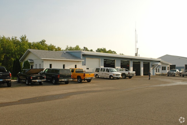
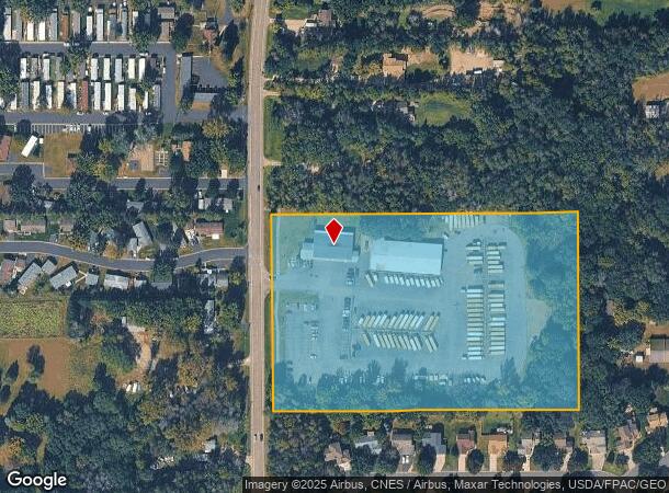
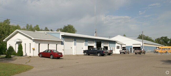
Property Record
6298 Hodgson Rd, Circle Pines, MN 55014
NEARBY LISTINGS FOR SALE OR LEASE
Property Detail
6298 Hodgson Rd
31-31-22-14-0006
Auditors Subdivision #46 Revised
Industrialgeneral
THAT PRT OF SE1/4 OF NE1/4 OF SEC 31 TWP 31 RGE 22 LYG W OF E 517 FT THEREOF & N OF THAT PRT PLATTED AS FOX TRACE, EX RD, SUB
X
Anoka
27003C0344E
Minnesota
2025
8.55 AC
2025
North Central
050237
Minneapolis/St Paul
8,422 SF
Minneapolis-St. Paul-Bloomington, MN-WI
DEMOGRAPHICS near 6298 Hodgson Rd
1 Mile
3 Mile
5 Mile
2024 Total Population
4,529
36,671
95,446
2029 Population
4,656
37,360
96,456
Pop Growth 2024-2029
+ 2.80%
+ 1.88%
+ 1.06%
Average Age
42
41
41
2024 Total Households
1,683
13,490
35,487
HH Growth 2024-2029
+ 2.79%
+ 1.83%
+ 0.74%
Median Household Inc
$114,072
$101,999
$103,896
Avg Household Size
2.60
2.60
2.60
2024 Avg HH Vehicles
2.00
2.00
2.00
Median Home Value
$360,331
$333,287
$348,549
Median Year Built
1992
1985
1985
Nearby Places
Map Layers
Map Styles
 Street
 Aerial
- Restaurants
- Banks
- Shops
- Fitness
- Groceries
PUBLIC TRANSPORTATION
AIRPORT
Minneapolis-St Paul International/Wold-Chamberlain
DRIVE
WALK
Distance
Minneapolis-St Paul International/Wold-Chamberlain
36 min
23.1 mi
Freight Ports
Port Milwaukee
DRIVE
WALK
Distance
Port Milwaukee
381 min
342.1 mi
Nearby Properties
Address
Land Use
TOTAL SIZE
Lot Size
Zoning
Address
Land Use
TOTAL SIZE
Lot Size
Zoning
467.27 AC
Address
Land Use
TOTAL SIZE
Lot Size
Zoning
226,201 SF
70.59 AC
Address
Land Use
TOTAL SIZE
Lot Size
Zoning
156,499 SF
81.20 AC
Address
Land Use
TOTAL SIZE
Lot Size
Zoning
264,300 SF
4.16 AC
Address
Land Use
TOTAL SIZE
Lot Size
Zoning
239,389 SF
5.73 AC
Address
Land Use
TOTAL SIZE
Lot Size
Zoning
606,798 SF
49.16 AC
Address
Land Use
TOTAL SIZE
Lot Size
Zoning
239,318 SF
Address
Land Use
TOTAL SIZE
Lot Size
Zoning
Address
Land Use
TOTAL SIZE
Lot Size
Zoning
150,034 SF
48.48 AC
Address
Land Use
TOTAL SIZE
Lot Size
Zoning
248,816 SF
14.02 AC
Address
Land Use
TOTAL SIZE
Lot Size
Zoning
265,400 SF
13.53 AC
Address
Land Use
TOTAL SIZE
Lot Size
Zoning
190,377 SF
9.61 AC
Address
Land Use
TOTAL SIZE
Lot Size
Zoning
109,136 SF
Address
Land Use
TOTAL SIZE
Lot Size
Zoning
46,557 SF
9.27 AC
Address
Land Use
TOTAL SIZE
Lot Size
Zoning
61,740 SF
16.10 AC
Address
Land Use
TOTAL SIZE
Lot Size
Zoning
77,940 SF
19.07 AC
Address
Land Use
TOTAL SIZE
Lot Size
Zoning
223,763 SF
24.89 AC
Address
Land Use
TOTAL SIZE
Lot Size
Zoning
235,504 SF
30.54 AC
Address
Land Use
TOTAL SIZE
Lot Size
Zoning
185,498 SF
25.01 AC
Address
Land Use
TOTAL SIZE
Lot Size
Zoning
243,028 SF
24.35 AC
Address
Land Use
TOTAL SIZE
Lot Size
Zoning
52,981 SF
5.27 AC
Address
Land Use
TOTAL SIZE
Lot Size
Zoning
61,617 SF
Address
Land Use
TOTAL SIZE
Lot Size
Zoning
32,314 SF
4.37 AC
Address
Land Use
TOTAL SIZE
Lot Size
Zoning
87,740 SF
5.98 AC
Address
Land Use
TOTAL SIZE
Lot Size
Zoning
177,390 SF
1.75 AC
Address
Land Use
TOTAL SIZE
Lot Size
Zoning
99,056 SF
6.57 AC
Address
Land Use
TOTAL SIZE
Lot Size
Zoning
91,397 SF
6.84 AC
Address
Land Use
TOTAL SIZE
Lot Size
Zoning
99,664 SF
6.75 AC
Address
Land Use
TOTAL SIZE
Lot Size
Zoning
109,470 SF
12.67 AC
Address
Land Use
TOTAL SIZE
Lot Size
Zoning
174,573 SF
10.40 AC
The World's #1 Commercial Real Estate Marketplace
Connect with us
© 2025 CoStar Group
The information above has been obtained from sources believed reliable. While we do not doubt its accuracy we have not verified it and make no guarantee, warranty or representation about it. It is your responsibility to independently confirm its accuracy and completeness. Any projections, opinions, assumptions, or estimates used are for example only and do not represent the current or future performance of the property. The value of this transaction to you depends on tax and other factors which should be evaluated by your tax, financial, and legal advisors. You and your advisors should conduct a careful, independent investigation of the property to determine to your satisfaction the suitability of the property for your needs.