Property Record
63 Copps Hill Rd, Ridgefield, CT 06877
Save to a Folder
{{folder.Name}}
{{folder.ListingIds.length}} Properties
{{folder.ListingIds.length}} Property
Create a New Folder
Property Detail
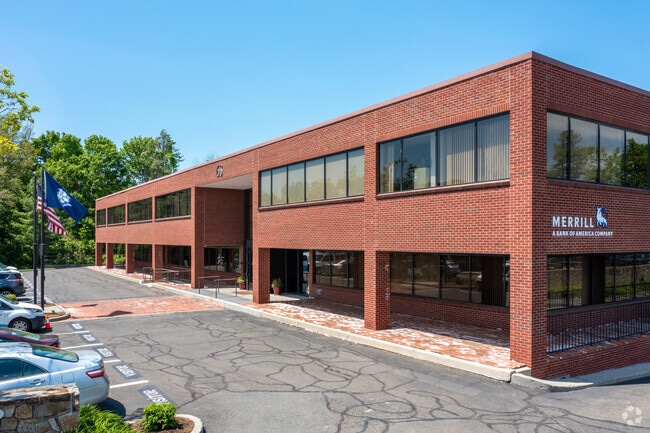
63 Copps Hill Rd
Commercialcondominium
Western Ct
B-1
Connecticut
AE The base floodplain where base flood elevations are provided. AE Zones are now used on new format FIRMs instead of A1-A30 Zones.
1 AC
2025
Ridgefield
2025
Westchester/So Connecticut
245100
Bridgeport-Stamford-Danbury, CT
1,320 SF
RIDG-000013-E000523
NEARBY LISTINGS FOR SALE OR LEASE
DEMOGRAPHICS near 63 Copps Hill Rd
1 mile
3 mile
5 mile
2025 Total Population
5,302
22,310
43,163
2030 Population
5,456
22,907
44,350
Pop Growth 2025-2030
+ 2.90%
+ 2.68%
+ 2.75%
Average Age
44
43
44
2025 Total Households
2,220
8,116
15,639
HH Growth 2025-2030
+ 2.93%
+ 2.67%
+ 2.78%
Median Household Inc
$103,382
$162,246
$170,297
Avg Household Size
2.40
2.70
2.70
2025 Avg HH Vehicles
2.00
2.00
2.00
Median Home Value
$761,171
$814,660
$788,539
Median Year Built
1976
1971
1971
Nearby Places
Map Layers
Map Styles
 Street
 Aerial
Layers
 Traffic
 Biking
Places
Listings with unknown addresses are not visible on the map
- Restaurants
- Banks
- Shops
- Fitness
- Groceries
PUBLIC TRANSPORTATION
COMMUTER RAIL
Redding Station (New Haven Line - Metro-North Commuter Railroad Company (Metro-North))
Drive
Walk
Distance
Redding Station (New Haven Line - Metro-North Commuter Railroad Company (Metro-North))
15 min
4.6 mi
Branchville Station (New Haven Line - Metro-North Commuter Railroad Company (Metro-North))
Drive
Walk
Distance
Branchville Station (New Haven Line - Metro-North Commuter Railroad Company (Metro-North))
9 min
4.8 mi
AIRPORT
Westchester County
Drive
Walk
Distance
Westchester County
42 min
27.7 mi
Tweed/New Haven
Drive
Walk
Distance
Tweed/New Haven
71 min
46.0 mi
New York Stewart International
Drive
Walk
Distance
New York Stewart International
71 min
47.4 mi
Freight Ports
Port of New Haven
Drive
Walk
Distance
Port of New Haven
65 min
43.8 mi
SALE & LEASE HISTORY
LISTING DATE
SALE/LEASE

Sep 24, 2016
For Sale
Sep 14, 2020
For Lease
Sep 11, 2020
For Lease
Nov 25, 2019
For Lease
Jan 31, 2023
For Lease
Jan 31, 2023
For Sale
Jan 05, 2017
For Lease
Jan 05, 2017
For Sale
Aug 05, 2017
For Sale
Nearby Properties
Address
Land Use
TOTAL SIZE
Lot Size
Zoning
Address
Land Use
TOTAL SIZE
Lot Size
Zoning
3,676 SF
77.59 AC
RAA
Address
Land Use
TOTAL SIZE
Lot Size
Zoning
183,028 SF
14.17 AC
RA
Address
Land Use
TOTAL SIZE
Lot Size
Zoning
162,265 SF
15.22 AC
B-1
Address
Land Use
TOTAL SIZE
Lot Size
Zoning
5,902 SF
30.40 AC
B-2
Address
Land Use
TOTAL SIZE
Lot Size
Zoning
108,918 SF
3.91 AC
B-2
Address
Land Use
TOTAL SIZE
Lot Size
Zoning
92,775 SF
85.83 AC
RAA
Address
Land Use
TOTAL SIZE
Lot Size
Zoning
117,561 SF
16.23 AC
RCDD
Address
Land Use
TOTAL SIZE
Lot Size
Zoning
47,150 SF
5 AC
R-75
Address
Land Use
TOTAL SIZE
Lot Size
Zoning
100,734 SF
22.55 AC
B-2
Address
Land Use
TOTAL SIZE
Lot Size
Zoning
16,389 SF
7.42 AC
CAH
Address
Land Use
TOTAL SIZE
Lot Size
Zoning
1,958 SF
42 AC
RAAA
Address
Land Use
TOTAL SIZE
Lot Size
Zoning
18,753 SF
276.88 AC
RAA
Address
Land Use
TOTAL SIZE
Lot Size
Zoning
4,226 SF
11.13 AC
B-2
Address
Land Use
TOTAL SIZE
Lot Size
Zoning
52,703 SF
48.18 AC
CCF
Address
Land Use
TOTAL SIZE
Lot Size
Zoning
14,215 SF
32.35 AC
RAA
Address
Land Use
TOTAL SIZE
Lot Size
Zoning
49,239 SF
13.01 AC
RA
Address
Land Use
TOTAL SIZE
Lot Size
Zoning
49,638 SF
12.24 AC
RAA
Address
Land Use
TOTAL SIZE
Lot Size
Zoning
12,348 SF
16 AC
RA
Address
Land Use
TOTAL SIZE
Lot Size
Zoning
1,238 SF
8.03 AC
ARHD2
Address
Land Use
TOTAL SIZE
Lot Size
Zoning
2,694 SF
156.19 AC
CDD
Address
Land Use
TOTAL SIZE
Lot Size
Zoning
89.74 AC
RAAA
Address
Land Use
TOTAL SIZE
Lot Size
Zoning
16,822 SF
4.98 AC
RA
Address
Land Use
TOTAL SIZE
Lot Size
Zoning
8,291 SF
1.23 AC
CBD
Address
Land Use
TOTAL SIZE
Lot Size
Zoning
23,852 SF
4.67 AC
CBD
Address
Land Use
TOTAL SIZE
Lot Size
Zoning
32,036 SF
1.95 AC
CBD
Address
Land Use
TOTAL SIZE
Lot Size
Zoning
143,837 SF
7.96 AC
SB
Address
Land Use
TOTAL SIZE
Lot Size
Zoning
7,138 SF
13.27 AC
RAA
Address
Land Use
TOTAL SIZE
Lot Size
Zoning
266.80 AC
RAA
Address
Land Use
TOTAL SIZE
Lot Size
Zoning
4,620 SF
5.26 AC
B-1
Address
Land Use
TOTAL SIZE
Lot Size
Zoning
16,968 SF
0.90 AC
CBD
The World's #1 Commercial Real Estate Marketplace
Connect with us
© 2026 CoStar Group
The information above has been obtained from sources believed reliable. While we do not doubt its accuracy we have not verified it and make no guarantee, warranty or representation about it. It is your responsibility to independently confirm its accuracy and completeness. Any projections, opinions, assumptions, or estimates used are for example only and do not represent the current or future performance of the property. The value of this transaction to you depends on tax and other factors which should be evaluated by your tax, financial, and legal advisors. You and your advisors should conduct a careful, independent investigation of the property to determine to your satisfaction the suitability of the property for your needs.