Property Record
63 E Main St, Moorestown, NJ 08057


Save to a Folder
{{folder.Name}}
{{folder.ListingIds.length}} Properties
{{folder.ListingIds.length}} Property
Create a New Folder
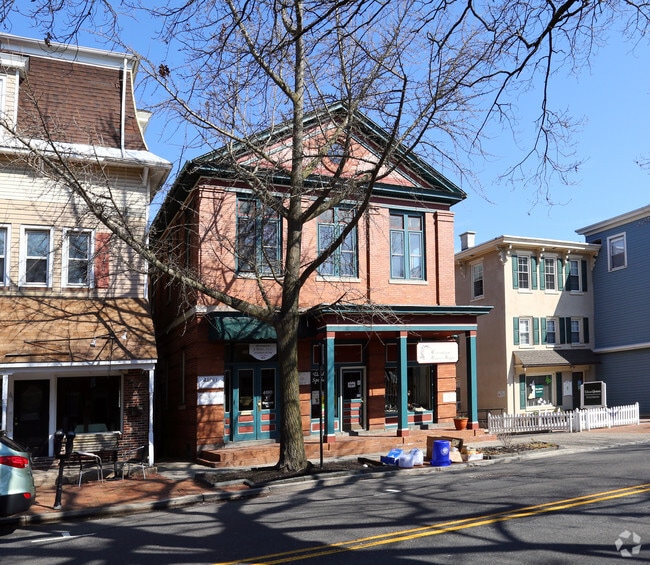
Property Detail
63 E Main St
22-04405-0000-00044
Burlington
Officebuilding
New Jersey
B and X Area of moderate flood hazard, usually the area between the limits of the 100-year and 500-year floods.
44
2025
0.16 AC
2026
North Burlington County
700504
Philadelphia
5,888 SF
Philadelphia-Camden-Wilmington, PA-NJ-DE-MD
NEARBY LISTINGS FOR SALE OR LEASE
DEMOGRAPHICS near 63 E Main St
1 mile
3 mile
5 mile
2025 Total Population
7,938
59,852
198,574
2030 Population
8,122
61,274
203,723
Pop Growth 2025-2030
+ 2.32%
+ 2.38%
+ 2.59%
Average Age
42
42
42
2025 Total Households
2,866
23,620
78,169
HH Growth 2025-2030
+ 2.41%
+ 2.47%
+ 2.67%
Median Household Inc
$149,261
$110,937
$109,476
Avg Household Size
2.70
2.50
2.50
2025 Avg HH Vehicles
2.00
2.00
2.00
Median Home Value
$615,232
$447,366
$371,933
Median Year Built
1953
1973
1973
Nearby Places
Map Layers
Map Styles
 Street
 Aerial
Layers
 Traffic
 Biking
Places
Listings with unknown addresses are not visible on the map
- Restaurants
- Banks
- Shops
- Fitness
- Groceries
PUBLIC TRANSPORTATION
COMMUTER RAIL
Cherry Hill (Atlantic City Line - NJ Transit Commuter Rail (NJ Transit))
Drive
Walk
Distance
Cherry Hill (Atlantic City Line - NJ Transit Commuter Rail (NJ Transit))
19 min
8.2 mi
AIRPORT
Philadelphia International
Drive
Walk
Distance
Philadelphia International
35 min
24.8 mi
Atlantic City International
Drive
Walk
Distance
Atlantic City International
78 min
48.5 mi
Nearby Properties
Address
Land Use
TOTAL SIZE
Lot Size
Zoning
Address
Land Use
TOTAL SIZE
Lot Size
Zoning
120.80 AC
Address
Land Use
TOTAL SIZE
Lot Size
Zoning
90.41 AC
Address
Land Use
TOTAL SIZE
Lot Size
Zoning
29.59 AC
Address
Land Use
TOTAL SIZE
Lot Size
Zoning
1 SF
42.23 AC
Address
Land Use
TOTAL SIZE
Lot Size
Zoning
39.71 AC
Address
Land Use
TOTAL SIZE
Lot Size
Zoning
199,049 SF
15.90 AC
Address
Land Use
TOTAL SIZE
Lot Size
Zoning
40.92 AC
Address
Land Use
TOTAL SIZE
Lot Size
Zoning
74.17 AC
BRMF
Address
Land Use
TOTAL SIZE
Lot Size
Zoning
16.69 AC
Address
Land Use
TOTAL SIZE
Lot Size
Zoning
6.25 AC
Address
Land Use
TOTAL SIZE
Lot Size
Zoning
25.84 AC
Address
Land Use
TOTAL SIZE
Lot Size
Zoning
25.58 AC
Address
Land Use
TOTAL SIZE
Lot Size
Zoning
999,999,999 SF
88.63 AC
Address
Land Use
TOTAL SIZE
Lot Size
Zoning
79.67 AC
I
Address
Land Use
TOTAL SIZE
Lot Size
Zoning
43.20 AC
Address
Land Use
TOTAL SIZE
Lot Size
Zoning
999,999,999 SF
21.10 AC
Address
Land Use
TOTAL SIZE
Lot Size
Zoning
15.02 AC
Address
Land Use
TOTAL SIZE
Lot Size
Zoning
28.96 AC
Address
Land Use
TOTAL SIZE
Lot Size
Zoning
15.10 AC
Address
Land Use
TOTAL SIZE
Lot Size
Zoning
19.79 AC
Address
Land Use
TOTAL SIZE
Lot Size
Zoning
27.77 AC
Address
Land Use
TOTAL SIZE
Lot Size
Zoning
Address
Land Use
TOTAL SIZE
Lot Size
Zoning
14.46 AC
Address
Land Use
TOTAL SIZE
Lot Size
Zoning
79.78 AC
Address
Land Use
TOTAL SIZE
Lot Size
Zoning
26.25 AC
Address
Land Use
TOTAL SIZE
Lot Size
Zoning
24,186 SF
15.01 AC
Address
Land Use
TOTAL SIZE
Lot Size
Zoning
13.98 AC
Address
Land Use
TOTAL SIZE
Lot Size
Zoning
13.15 AC
Address
Land Use
TOTAL SIZE
Lot Size
Zoning
15.49 AC
Address
Land Use
TOTAL SIZE
Lot Size
Zoning
The World's #1 Commercial Real Estate Marketplace
Connect with us
© 2026 CoStar Group
The information above has been obtained from sources believed reliable. While we do not doubt its accuracy we have not verified it and make no guarantee, warranty or representation about it. It is your responsibility to independently confirm its accuracy and completeness. Any projections, opinions, assumptions, or estimates used are for example only and do not represent the current or future performance of the property. The value of this transaction to you depends on tax and other factors which should be evaluated by your tax, financial, and legal advisors. You and your advisors should conduct a careful, independent investigation of the property to determine to your satisfaction the suitability of the property for your needs.