Property Record
63 Highway 95, Rock Spring, GA 30739
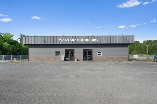

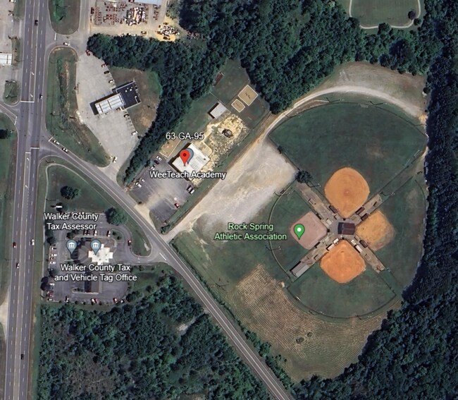
This Property Is For Sale
Property Detail
63 Highway 95
03271-042
TR 4 SHIELDS ESTATE
Daycare
Walker
C1
Georgia
A Areas with a 1% annual chance of flooding and a 26% chance of flooding over the life of a 30-year mortgage.
1.88 AC
2025
Walker County
2025
Chattanooga
020601
Chattanooga, TN-GA
5,600 SF
NEARBY LISTINGS FOR SALE OR LEASE
-
-
View all Rock Spring listings for sale on LoopNet.com
DEMOGRAPHICS near 63 Highway 95
1 mile
3 mile
5 mile
2025 Total Population
1,225
6,629
17,267
2030 Population
1,230
6,673
17,450
Pop Growth 2025-2030
+ 0.41%
+ 0.66%
+ 1.06%
Average Age
42
42
42
2025 Total Households
436
2,330
6,307
HH Growth 2025-2030
+ 0.46%
+ 0.90%
+ 1.21%
Median Household Inc
$69,733
$77,194
$80,256
Avg Household Size
2.60
2.60
2.60
2025 Avg HH Vehicles
2.00
2.00
2.00
Median Home Value
$318,557
$321,875
$310,235
Median Year Built
1995
1994
1994
Nearby Places
Map Layers
Map Styles
 Street
 Aerial
Layers
 Traffic
 Biking
Places
Listings with unknown addresses are not visible on the map
- Restaurants
- Banks
- Shops
- Fitness
- Groceries
PUBLIC TRANSPORTATION
AIRPORT
Lovell Field
Drive
Walk
Distance
Lovell Field
36 min
18.8 mi
Nearby Properties
Address
Land Use
TOTAL SIZE
Lot Size
Zoning
Address
Land Use
TOTAL SIZE
Lot Size
Zoning
139,313 SF
R2
Address
Land Use
TOTAL SIZE
Lot Size
Zoning
114,092 SF
94.52 AC
A1
Address
Land Use
TOTAL SIZE
Lot Size
Zoning
71,328 SF
17.28 AC
C1
Address
Land Use
TOTAL SIZE
Lot Size
Zoning
14,716 SF
2.10 AC
C1
Address
Land Use
TOTAL SIZE
Lot Size
Zoning
2,805 SF
2.46 AC
PUD
Address
Land Use
TOTAL SIZE
Lot Size
Zoning
38,500 SF
4.06 AC
R2
Address
Land Use
TOTAL SIZE
Lot Size
Zoning
8,050 SF
22.98 AC
I
Address
Land Use
TOTAL SIZE
Lot Size
Zoning
14,725 SF
10.47 AC
R2
Address
Land Use
TOTAL SIZE
Lot Size
Zoning
3.87 AC
C1
Address
Land Use
TOTAL SIZE
Lot Size
Zoning
16.18 AC
C1
Address
Land Use
TOTAL SIZE
Lot Size
Zoning
36,190 SF
14.79 AC
A1
Address
Land Use
TOTAL SIZE
Lot Size
Zoning
19,000 SF
10 AC
R2
Address
Land Use
TOTAL SIZE
Lot Size
Zoning
10,780 SF
1.80 AC
C1
Address
Land Use
TOTAL SIZE
Lot Size
Zoning
4,181 SF
11.34 AC
C1
Address
Land Use
TOTAL SIZE
Lot Size
Zoning
1,614 SF
4.91 AC
R2
Address
Land Use
TOTAL SIZE
Lot Size
Zoning
3,448 SF
2.96 AC
C1
Address
Land Use
TOTAL SIZE
Lot Size
Zoning
189 AC
A1
Address
Land Use
TOTAL SIZE
Lot Size
Zoning
72,840 SF
16.54 AC
R2
Address
Land Use
TOTAL SIZE
Lot Size
Zoning
3,911 SF
5.39 AC
A-1
Address
Land Use
TOTAL SIZE
Lot Size
Zoning
10,721 SF
2.43 AC
C1
Address
Land Use
TOTAL SIZE
Lot Size
Zoning
10,721 SF
2.43 AC
C1
Address
Land Use
TOTAL SIZE
Lot Size
Zoning
518.95 AC
A1
Address
Land Use
TOTAL SIZE
Lot Size
Zoning
333 AC
A1
Address
Land Use
TOTAL SIZE
Lot Size
Zoning
33,300 SF
5.83 AC
A1
Address
Land Use
TOTAL SIZE
Lot Size
Zoning
304 AC
A-1
Address
Land Use
TOTAL SIZE
Lot Size
Zoning
8 AC
PUD
Address
Land Use
TOTAL SIZE
Lot Size
Zoning
6,000 SF
0.99 AC
C1
Address
Land Use
TOTAL SIZE
Lot Size
Zoning
11,820 SF
4.12 AC
C1
Address
Land Use
TOTAL SIZE
Lot Size
Zoning
166.90 AC
A-1
Address
Land Use
TOTAL SIZE
Lot Size
Zoning
8,340 SF
1 AC
C
The World's #1 Commercial Real Estate Marketplace
Connect with us
© 2026 CoStar Group
The information above has been obtained from sources believed reliable. While we do not doubt its accuracy we have not verified it and make no guarantee, warranty or representation about it. It is your responsibility to independently confirm its accuracy and completeness. Any projections, opinions, assumptions, or estimates used are for example only and do not represent the current or future performance of the property. The value of this transaction to you depends on tax and other factors which should be evaluated by your tax, financial, and legal advisors. You and your advisors should conduct a careful, independent investigation of the property to determine to your satisfaction the suitability of the property for your needs.