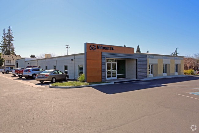
Property Record
Wales Dr, Folsom, CA 95630
Current Lease Availabilities
NEARBY LISTINGS FOR SALE OR LEASE
Property Detail
Wales Dr
Sacramento--Roseville--Arden-Arcade, CA
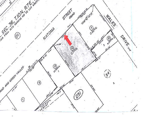
Parcel Map
071-0251-016
PARCEL MAP, LOT 2
Parkinglot
Sacramento
X
California
06067C0116J
2
2024
0.22 AC
2025
Folsom/El Dorado
008402
Sacramento
DEMOGRAPHICS near Wales Dr
1 Mile
3 Mile
5 Mile
2024 Total Population
14,235
84,054
164,179
2029 Population
14,313
84,674
166,902
Pop Growth 2024-2029
+ 0.55%
+ 0.74%
+ 1.66%
Average Age
42
41
42
2024 Total Households
3,804
30,694
59,497
HH Growth 2024-2029
+ 0.79%
+ 0.80%
+ 1.62%
Median Household Inc
$87,831
$116,836
$123,302
Avg Household Size
2.30
2.50
2.60
2024 Avg HH Vehicles
2.00
2.00
2.00
Median Home Value
$618,341
$683,116
$706,545
Median Year Built
1978
1990
1990
Nearby Places
- Restaurants
- Banks
- Shops
- Fitness
- Groceries
PUBLIC TRANSPORTATION
AIRPORT
Sacramento International
DRIVE
WALK
Distance
Sacramento International
44 min
29.5 mi
Freight Ports
Port of Stockton
DRIVE
WALK
Distance
Port of Stockton
82 min
68.3 mi
Nearby Properties
Address
Land Use
TOTAL SIZE
Lot Size
Zoning
Address
Land Use
TOTAL SIZE
Lot Size
Zoning
1,686,420 SF
161.78 AC
M-1 (PD)
Address
Land Use
TOTAL SIZE
Lot Size
Zoning
278,000 SF
28.48 AC
SP-LI/BP (
Address
Land Use
TOTAL SIZE
Lot Size
Zoning
424,801 SF
32.65 AC
R-M (PD)
Address
Land Use
TOTAL SIZE
Lot Size
Zoning
311,043 SF
10.10 AC
R-4 (PD)
Address
Land Use
TOTAL SIZE
Lot Size
Zoning
302,124 SF
13.30 AC
R-M (PD)
Address
Land Use
TOTAL SIZE
Lot Size
Zoning
129,465 SF
8.30 AC
C-1 (PD)
Address
Land Use
TOTAL SIZE
Lot Size
Zoning
243,460 SF
20.46 AC
C-3 (PD)
Address
Land Use
TOTAL SIZE
Lot Size
Zoning
221,948 SF
15.94 AC
R-M (PD)
Address
Land Use
TOTAL SIZE
Lot Size
Zoning
115,076 SF
22.09 AC
SP-INDUSTR
Address
Land Use
TOTAL SIZE
Lot Size
Zoning
6.02 AC
C-3 (PD)
Address
Land Use
TOTAL SIZE
Lot Size
Zoning
121,378 SF
11.29 AC
M-L (PD)
Address
Land Use
TOTAL SIZE
Lot Size
Zoning
287,131 SF
32.53 AC
C-3 (PD)
Address
Land Use
TOTAL SIZE
Lot Size
Zoning
289,557 SF
28.31 AC
R-M (PD)
Address
Land Use
TOTAL SIZE
Lot Size
Zoning
264,478 SF
13.46 AC
R-M (PD)
Address
Land Use
TOTAL SIZE
Lot Size
Zoning
415,320 SF
32.51 AC
R-M (PD) O
Address
Land Use
TOTAL SIZE
Lot Size
Zoning
140,000 SF
4.12 AC
BP (PD)
Address
Land Use
TOTAL SIZE
Lot Size
Zoning
157,580 SF
16.93 AC
R-M
Address
Land Use
TOTAL SIZE
Lot Size
Zoning
40,447 SF
8.89 AC
M-1
Address
Land Use
TOTAL SIZE
Lot Size
Zoning
5.73 AC
R-4 (PD)
Address
Land Use
TOTAL SIZE
Lot Size
Zoning
163,800 SF
9.13 AC
SP-IND/OP
Address
Land Use
TOTAL SIZE
Lot Size
Zoning
293,505 SF
27.52 AC
R-M (PD)
Address
Land Use
TOTAL SIZE
Lot Size
Zoning
111,103 SF
11.33 AC
C-3 (PD)
Address
Land Use
TOTAL SIZE
Lot Size
Zoning
52,992 SF
4.07 AC
M-1 (PD)
Address
Land Use
TOTAL SIZE
Lot Size
Zoning
54,336 SF
4.88 AC
BP (PD)
Address
Land Use
TOTAL SIZE
Lot Size
Zoning
153,983 SF
4.16 AC
MU
Address
Land Use
TOTAL SIZE
Lot Size
Zoning
121,155 SF
4.70 AC
C-2 (PD)
Address
Land Use
TOTAL SIZE
Lot Size
Zoning
296,680 SF
7.69 AC
R-M (PD)
Address
Land Use
TOTAL SIZE
Lot Size
Zoning
138,332 SF
13.70 AC
R-M (PD)
Address
Land Use
TOTAL SIZE
Lot Size
Zoning
104,750 SF
5.66 AC
RD-20
Address
Land Use
TOTAL SIZE
Lot Size
Zoning
121,190 SF
6.65 AC
R-4 (PD)
The World's #1 Commercial Real Estate Marketplace
Connect with us
© 2025 CoStar Group
The information above has been obtained from sources believed reliable. While we do not doubt its accuracy we have not verified it and make no guarantee, warranty or representation about it. It is your responsibility to independently confirm its accuracy and completeness. Any projections, opinions, assumptions, or estimates used are for example only and do not represent the current or future performance of the property. The value of this transaction to you depends on tax and other factors which should be evaluated by your tax, financial, and legal advisors. You and your advisors should conduct a careful, independent investigation of the property to determine to your satisfaction the suitability of the property for your needs.