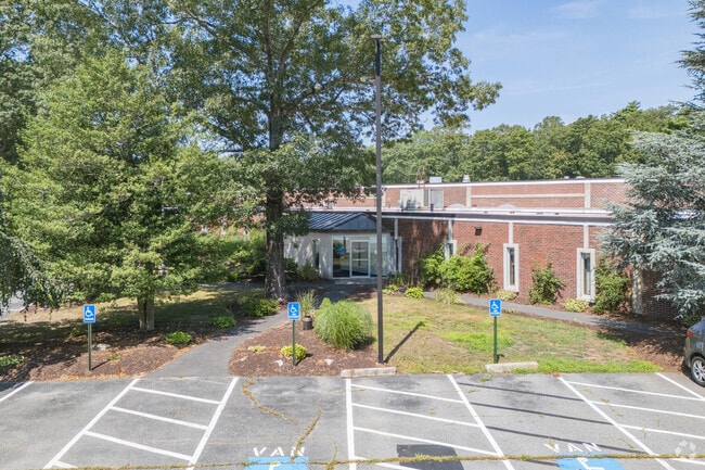
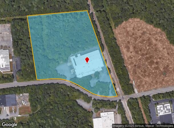
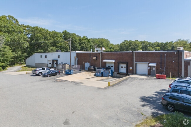
Property Record
55 Samuel Barnet Blvd, New Bedford, MA 02745
NEARBY LISTINGS FOR SALE OR LEASE
Property Detail
55 Samuel Barnet Blvd
NEWB-000133-000000-000036
New Bedford
Manufacturinglight
Bristol
X
Massachusetts
25005C0377G
36
2025
11.09 AC
2025
Attleboro/New Bedford
650201
Boston
64,309 SF
Providence-Warwick, RI-MA
DEMOGRAPHICS near 55 Samuel Barnet Blvd
1 Mile
3 Mile
5 Mile
2024 Total Population
3,362
20,950
65,950
2029 Population
3,350
20,807
64,873
Pop Growth 2024-2029
(0.36%)
(0.68%)
(1.63%)
Average Age
42
43
40
2024 Total Households
1,402
8,259
26,144
HH Growth 2024-2029
(0.43%)
(0.71%)
(1.71%)
Median Household Inc
$84,901
$89,818
$65,399
Avg Household Size
2.30
2.50
2.40
2024 Avg HH Vehicles
2.00
2.00
2.00
Median Home Value
$306,788
$346,155
$345,768
Median Year Built
1977
1975
1958
Nearby Places
- Restaurants
- Banks
- Shops
- Fitness
- Groceries
PUBLIC TRANSPORTATION
AIRPORT
Rhode Island Tf Green International
DRIVE
WALK
Distance
Rhode Island Tf Green International
60 min
40.8 mi
SALE & LEASE HISTORY
LISTING DATE
SALE/LEASE

Mar 02, 2018
For Sale
Nearby Properties
Address
Land Use
TOTAL SIZE
Lot Size
Zoning
Address
Land Use
TOTAL SIZE
Lot Size
Zoning
23.22 AC
RB
Address
Land Use
TOTAL SIZE
Lot Size
Zoning
157,346 SF
5.68 AC
RA
Address
Land Use
TOTAL SIZE
Lot Size
Zoning
54.60 AC
Address
Land Use
TOTAL SIZE
Lot Size
Zoning
44,156 SF
5.18 AC
GI
Address
Land Use
TOTAL SIZE
Lot Size
Zoning
31.14 AC
R
Address
Land Use
TOTAL SIZE
Lot Size
Zoning
492.70 AC
IC
Address
Land Use
TOTAL SIZE
Lot Size
Zoning
225,292 SF
29.27 AC
IC
Address
Land Use
TOTAL SIZE
Lot Size
Zoning
239,765 SF
31.86 AC
IC
Address
Land Use
TOTAL SIZE
Lot Size
Zoning
306.30 AC
IC
Address
Land Use
TOTAL SIZE
Lot Size
Zoning
6.46 AC
MUB
Address
Land Use
TOTAL SIZE
Lot Size
Zoning
199,978 SF
31.41 AC
IC
Address
Land Use
TOTAL SIZE
Lot Size
Zoning
169,928 SF
31.88 AC
GI
Address
Land Use
TOTAL SIZE
Lot Size
Zoning
5.49 AC
RB
Address
Land Use
TOTAL SIZE
Lot Size
Zoning
5,208 SF
152.06 AC
GI
Address
Land Use
TOTAL SIZE
Lot Size
Zoning
9.79 AC
IA
Address
Land Use
TOTAL SIZE
Lot Size
Zoning
118,757 SF
61.52 AC
IC
Address
Land Use
TOTAL SIZE
Lot Size
Zoning
6.34 AC
RA
Address
Land Use
TOTAL SIZE
Lot Size
Zoning
62,408 SF
12.60 AC
RA
Address
Land Use
TOTAL SIZE
Lot Size
Zoning
95,972 SF
9.40 AC
IC
Address
Land Use
TOTAL SIZE
Lot Size
Zoning
5.64 AC
MUB
Address
Land Use
TOTAL SIZE
Lot Size
Zoning
4,041 SF
31.91 AC
Address
Land Use
TOTAL SIZE
Lot Size
Zoning
51,243 SF
8.51 AC
RA
Address
Land Use
TOTAL SIZE
Lot Size
Zoning
136,521 SF
18.46 AC
IC
Address
Land Use
TOTAL SIZE
Lot Size
Zoning
54,513 SF
4.28 AC
IA
Address
Land Use
TOTAL SIZE
Lot Size
Zoning
114,908 SF
14.19 AC
IC
Address
Land Use
TOTAL SIZE
Lot Size
Zoning
46,083 SF
8.43 AC
MUB
Address
Land Use
TOTAL SIZE
Lot Size
Zoning
72,764 SF
17.88 AC
GI
Address
Land Use
TOTAL SIZE
Lot Size
Zoning
71 AC
R
Address
Land Use
TOTAL SIZE
Lot Size
Zoning
178.14 AC
IB
Address
Land Use
TOTAL SIZE
Lot Size
Zoning
310.20 AC
RA
The World's #1 Commercial Real Estate Marketplace
Connect with us
© 2025 CoStar Group
The information above has been obtained from sources believed reliable. While we do not doubt its accuracy we have not verified it and make no guarantee, warranty or representation about it. It is your responsibility to independently confirm its accuracy and completeness. Any projections, opinions, assumptions, or estimates used are for example only and do not represent the current or future performance of the property. The value of this transaction to you depends on tax and other factors which should be evaluated by your tax, financial, and legal advisors. You and your advisors should conduct a careful, independent investigation of the property to determine to your satisfaction the suitability of the property for your needs.