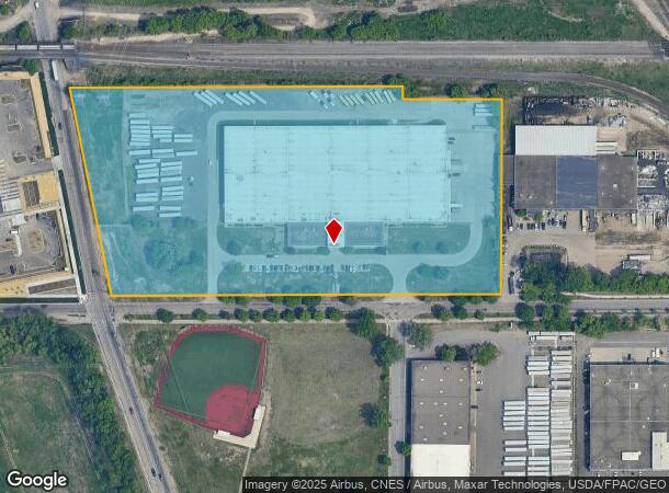
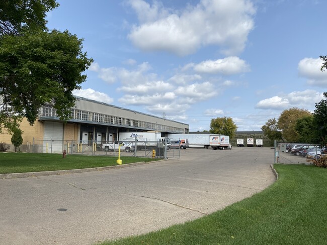
Property Record
63 Saint Anthony Pky, Minneapolis, MN 55418
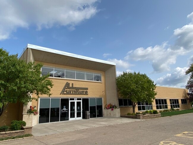

This Property Is For Sale
Current Lease Availabilities
NEARBY LISTINGS FOR SALE OR LEASE
Property Detail
63 Saint Anthony Pky
Minneapolis-St. Paul-Bloomington, MN-WI
Auditors Subd. No. 035
03-029-24-13-0004
LOT 009 A AUDITORS SUBD. NO. 035 N 521 3/10 FT OF THE S 561 3/10 FT OF LOT 9 AND THAT PART OF THE W 250 FT OF LOTS 6 AND 7 LYING S OF R R R/W AND N OF ST ANTHONY BOULEVARD IRREGULAR
Industrialgeneral
Hennepin
X
Minnesota
27053C0219F
9
2024
12.36 AC
2024
Minneapolis
100500
Minneapolis/St Paul
153,559 SF
DEMOGRAPHICS near 63 Saint Anthony Pky
1 Mile
3 Mile
5 Mile
2024 Total Population
7,226
147,295
388,042
2029 Population
7,142
145,544
383,843
Pop Growth 2024-2029
(1.16%)
(1.19%)
(1.08%)
Average Age
36
37
37
2024 Total Households
2,718
60,055
163,774
HH Growth 2024-2029
(1.25%)
(1.17%)
(1.03%)
Median Household Inc
$58,326
$69,997
$65,164
Avg Household Size
2.50
2.30
2.20
2024 Avg HH Vehicles
2.00
2.00
1.00
Median Home Value
$235,891
$254,448
$274,919
Median Year Built
1949
1956
1965
Nearby Places
Map Layers
Map Styles
 Street
 Aerial
- Restaurants
- Banks
- Shops
- Fitness
- Groceries
PUBLIC TRANSPORTATION
COMMUTER RAIL
Target Field Station (Northstar Corridor - Northstar Commuter Rail)
DRIVE
WALK
Distance
Target Field Station (Northstar Corridor - Northstar Commuter Rail)
11 min
3.9 mi
Fridley Station (Northstar Corridor - Northstar Commuter Rail)
DRIVE
WALK
Distance
Fridley Station (Northstar Corridor - Northstar Commuter Rail)
7 min
4.0 mi
AIRPORT
Minneapolis-St Paul International/Wold-Chamberlain
DRIVE
WALK
Distance
Minneapolis-St Paul International/Wold-Chamberlain
30 min
14.5 mi
Freight Ports
Port Milwaukee
DRIVE
WALK
Distance
Port Milwaukee
384 min
347.5 mi
Nearby Properties
Address
Land Use
TOTAL SIZE
Lot Size
Zoning
Address
Land Use
TOTAL SIZE
Lot Size
Zoning
2.67 AC
C3A
Address
Land Use
TOTAL SIZE
Lot Size
Zoning
1 SF
69.72 AC
I3
Address
Land Use
TOTAL SIZE
Lot Size
Zoning
557,654 SF
3.15 AC
C2
Address
Land Use
TOTAL SIZE
Lot Size
Zoning
478,616 SF
2.28 AC
C2
Address
Land Use
TOTAL SIZE
Lot Size
Zoning
513,403 SF
0.73 AC
C2
Address
Land Use
TOTAL SIZE
Lot Size
Zoning
341,894 SF
2.62 AC
R6
Address
Land Use
TOTAL SIZE
Lot Size
Zoning
502,092 SF
1.16 AC
B4N
Address
Land Use
TOTAL SIZE
Lot Size
Zoning
142,933 SF
5.57 AC
Address
Land Use
TOTAL SIZE
Lot Size
Zoning
431,472 SF
7.04 AC
Address
Land Use
TOTAL SIZE
Lot Size
Zoning
399,841 SF
2.51 AC
C3A
Address
Land Use
TOTAL SIZE
Lot Size
Zoning
405,028 SF
B4N
Address
Land Use
TOTAL SIZE
Lot Size
Zoning
199,433 SF
0.68 AC
C2
Address
Land Use
TOTAL SIZE
Lot Size
Zoning
225,845 SF
1 AC
C3A
Address
Land Use
TOTAL SIZE
Lot Size
Zoning
661,904 SF
6.49 AC
C3A
Address
Land Use
TOTAL SIZE
Lot Size
Zoning
Address
Land Use
TOTAL SIZE
Lot Size
Zoning
204,825 SF
1.15 AC
B4S-1
Address
Land Use
TOTAL SIZE
Lot Size
Zoning
458,954 SF
1.73 AC
B4N
Address
Land Use
TOTAL SIZE
Lot Size
Zoning
265,561 SF
1.22 AC
B4N
Address
Land Use
TOTAL SIZE
Lot Size
Zoning
166.50 AC
Address
Land Use
TOTAL SIZE
Lot Size
Zoning
204,510 SF
2.74 AC
I2
Address
Land Use
TOTAL SIZE
Lot Size
Zoning
229,978 SF
2.43 AC
C3A
Address
Land Use
TOTAL SIZE
Lot Size
Zoning
245,029 SF
1.36 AC
B4S-1
Address
Land Use
TOTAL SIZE
Lot Size
Zoning
194,647 SF
0.78 AC
B4S-1
Address
Land Use
TOTAL SIZE
Lot Size
Zoning
2.67 AC
C3A
Address
Land Use
TOTAL SIZE
Lot Size
Zoning
Address
Land Use
TOTAL SIZE
Lot Size
Zoning
183,782 SF
0.82 AC
C3A
Address
Land Use
TOTAL SIZE
Lot Size
Zoning
249,357 SF
6 AC
Address
Land Use
TOTAL SIZE
Lot Size
Zoning
19,514 SF
70.59 AC
Address
Land Use
TOTAL SIZE
Lot Size
Zoning
255,096 SF
2.61 AC
Address
Land Use
TOTAL SIZE
Lot Size
Zoning
65,400 SF
3.03 AC
OR2
The World's #1 Commercial Real Estate Marketplace
Connect with us
© 2025 CoStar Group
The information above has been obtained from sources believed reliable. While we do not doubt its accuracy we have not verified it and make no guarantee, warranty or representation about it. It is your responsibility to independently confirm its accuracy and completeness. Any projections, opinions, assumptions, or estimates used are for example only and do not represent the current or future performance of the property. The value of this transaction to you depends on tax and other factors which should be evaluated by your tax, financial, and legal advisors. You and your advisors should conduct a careful, independent investigation of the property to determine to your satisfaction the suitability of the property for your needs.