Property Record
63 Tarragona, Roanoke, TX 76262


Property Detail
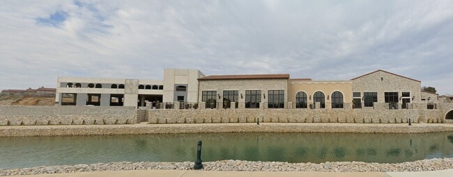
63 Tarragona
Dallas-Fort Worth-Arlington, TX
WESTLAKE ENTRADA BLOCK C LOT 5
42402415
TARRANT
Commercialnec
Texas
B and X Area of moderate flood hazard, usually the area between the limits of the 100-year and 500-year floods.
5
2025
0.60 AC
2025
Trophy/Roanoke/W'Lake
020311
Dallas/Ft Worth
15,268 SF
NEARBY LISTINGS FOR SALE OR LEASE
DEMOGRAPHICS near 63 Tarragona
1 mile
3 mile
5 mile
2025 Total Population
5,748
37,244
99,675
2030 Population
6,354
40,546
107,584
Pop Growth 2025-2030
+ 10.54%
+ 8.87%
+ 7.93%
Average Age
43
41
41
2025 Total Households
2,019
12,101
33,290
HH Growth 2025-2030
+ 10.85%
+ 9.24%
+ 8.22%
Median Household Inc
$201,281
$210,685
$194,333
Avg Household Size
2.80
3.10
3.00
2025 Avg HH Vehicles
2.00
2.00
2.00
Median Home Value
$763,075
$810,787
$781,057
Median Year Built
1994
1999
1999
Nearby Places
Map Layers
Map Styles
 Street
 Aerial
Layers
 Traffic
 Biking
Places
Listings with unknown addresses are not visible on the map
- Restaurants
- Banks
- Shops
- Fitness
- Groceries
PUBLIC TRANSPORTATION
AIRPORT
Dallas-Fort Worth International
Drive
Walk
Distance
Dallas-Fort Worth International
19 min
13.4 mi
Dallas Love Field
Drive
Walk
Distance
Dallas Love Field
37 min
27.1 mi
SALE & LEASE HISTORY
LISTING DATE
SALE/LEASE

May 31, 2023
For Lease
Nearby Properties
Address
Land Use
TOTAL SIZE
Lot Size
Zoning
Address
Land Use
TOTAL SIZE
Lot Size
Zoning
1,213,448 SF
59.10 AC
Address
Land Use
TOTAL SIZE
Lot Size
Zoning
1,315,600 SF
106.95 AC
Address
Land Use
TOTAL SIZE
Lot Size
Zoning
254,250 SF
6.21 AC
Address
Land Use
TOTAL SIZE
Lot Size
Zoning
1,603,686 SF
81.43 AC
Address
Land Use
TOTAL SIZE
Lot Size
Zoning
1,872,003 SF
52.16 AC
Address
Land Use
TOTAL SIZE
Lot Size
Zoning
1,420,661 SF
40.78 AC
Address
Land Use
TOTAL SIZE
Lot Size
Zoning
314,692 SF
78.63 AC
Address
Land Use
TOTAL SIZE
Lot Size
Zoning
371,473 SF
82.85 AC
Address
Land Use
TOTAL SIZE
Lot Size
Zoning
645,587 SF
12.57 AC
Address
Land Use
TOTAL SIZE
Lot Size
Zoning
191,001 SF
17.58 AC
Address
Land Use
TOTAL SIZE
Lot Size
Zoning
597,855 SF
Address
Land Use
TOTAL SIZE
Lot Size
Zoning
1,188,418 SF
20.15 AC
Address
Land Use
TOTAL SIZE
Lot Size
Zoning
219,109 SF
24.78 AC
Address
Land Use
TOTAL SIZE
Lot Size
Zoning
262,306 SF
8.02 AC
Address
Land Use
TOTAL SIZE
Lot Size
Zoning
121,348 SF
13.78 AC
Address
Land Use
TOTAL SIZE
Lot Size
Zoning
188,500 SF
6.28 AC
Address
Land Use
TOTAL SIZE
Lot Size
Zoning
133,430 SF
19.75 AC
Address
Land Use
TOTAL SIZE
Lot Size
Zoning
317,920 SF
3.42 AC
Address
Land Use
TOTAL SIZE
Lot Size
Zoning
463,990 SF
Address
Land Use
TOTAL SIZE
Lot Size
Zoning
244,297 SF
6.29 AC
Address
Land Use
TOTAL SIZE
Lot Size
Zoning
50,274 SF
6.93 AC
Address
Land Use
TOTAL SIZE
Lot Size
Zoning
158,844 SF
0.23 AC
Address
Land Use
TOTAL SIZE
Lot Size
Zoning
105,813 SF
12.68 AC
Address
Land Use
TOTAL SIZE
Lot Size
Zoning
104,438 SF
10.85 AC
Address
Land Use
TOTAL SIZE
Lot Size
Zoning
103,264 SF
4.68 AC
Address
Land Use
TOTAL SIZE
Lot Size
Zoning
55,704 SF
24.59 AC
Address
Land Use
TOTAL SIZE
Lot Size
Zoning
40,000 SF
16.94 AC
Address
Land Use
TOTAL SIZE
Lot Size
Zoning
Address
Land Use
TOTAL SIZE
Lot Size
Zoning
52,386 SF
5.51 AC
Address
Land Use
TOTAL SIZE
Lot Size
Zoning
79.30 AC
The World's #1 Commercial Real Estate Marketplace
Connect with us
© 2026 CoStar Group
The information above has been obtained from sources believed reliable. While we do not doubt its accuracy we have not verified it and make no guarantee, warranty or representation about it. It is your responsibility to independently confirm its accuracy and completeness. Any projections, opinions, assumptions, or estimates used are for example only and do not represent the current or future performance of the property. The value of this transaction to you depends on tax and other factors which should be evaluated by your tax, financial, and legal advisors. You and your advisors should conduct a careful, independent investigation of the property to determine to your satisfaction the suitability of the property for your needs.