Property Record
630 E Twincourt Trl, Saint Augustine, FL 32095
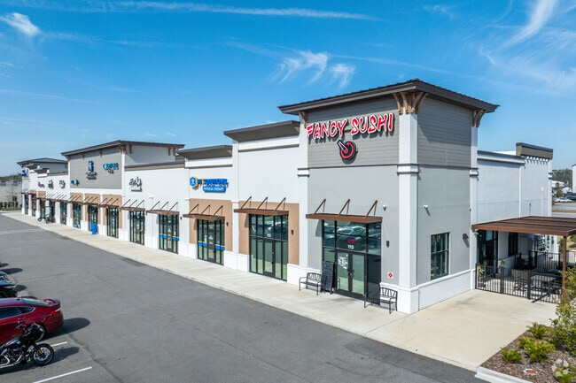

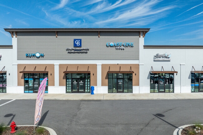
Property Detail
630 E Twincourt Trl
027090-0062
2-6B PTS OF GL 1 LYING S OF INTERNATIONAL GOLF PARKWAY - SOUTHEAST QUADRANT PARCELS 6.2 & 6.3 OR2791/1173
Regionalshoppingcenterormallwithanchorstore
ST. JOHNS
PUD
Florida
B and X Area of moderate flood hazard, usually the area between the limits of the 100-year and 500-year floods.
2.65 AC
2023
St Johns County
2025
Jacksonville (Florida)
020904
Jacksonville, FL
21,936 SF
NEARBY LISTINGS FOR SALE OR LEASE
DEMOGRAPHICS near 630 E Twincourt Trl
1 mile
3 mile
5 mile
2025 Total Population
2,826
10,139
40,745
2030 Population
3,453
12,069
47,774
Pop Growth 2025-2030
+ 22.19%
+ 19.04%
+ 17.25%
Average Age
39
46
42
2025 Total Households
1,052
4,124
14,609
HH Growth 2025-2030
+ 22.24%
+ 19.47%
+ 17.98%
Median Household Inc
$110,152
$107,609
$118,477
Avg Household Size
2.70
2.40
2.70
2025 Avg HH Vehicles
2.00
2.00
2.00
Median Home Value
$494,611
$464,313
$508,208
Median Year Built
2011
2010
2010
Nearby Places
Map Layers
Map Styles
 Street
 Aerial
Transit
 Traffic
 Biking
Places
Listings with unknown addresses are not visible on the map
- Restaurants
- Banks
- Shops
- Fitness
- Groceries
SALE & LEASE HISTORY
LISTING DATE
SALE/LEASE

Oct 04, 2021
For Lease
Nov 21, 2019
For Lease
Nov 12, 2025
For Lease
Feb 27, 2019
For Lease
Nearby Properties
Address
Land Use
TOTAL SIZE
Lot Size
Zoning
Address
Land Use
TOTAL SIZE
Lot Size
Zoning
223,545 SF
68.79 AC
OR
Address
Land Use
TOTAL SIZE
Lot Size
Zoning
312,893 SF
12.30 AC
Address
Land Use
TOTAL SIZE
Lot Size
Zoning
252,962 SF
6.86 AC
Address
Land Use
TOTAL SIZE
Lot Size
Zoning
228,680 SF
11.13 AC
Address
Land Use
TOTAL SIZE
Lot Size
Zoning
157,964 SF
66.39 AC
PUD
Address
Land Use
TOTAL SIZE
Lot Size
Zoning
90,363 SF
15.69 AC
PUD
Address
Land Use
TOTAL SIZE
Lot Size
Zoning
346,512 SF
40.12 AC
PUD
Address
Land Use
TOTAL SIZE
Lot Size
Zoning
109,852 SF
12.62 AC
Address
Land Use
TOTAL SIZE
Lot Size
Zoning
99,542 SF
18.10 AC
Address
Land Use
TOTAL SIZE
Lot Size
Zoning
52,896 SF
13.70 AC
Address
Land Use
TOTAL SIZE
Lot Size
Zoning
151,858 SF
17.24 AC
Address
Land Use
TOTAL SIZE
Lot Size
Zoning
150,535 SF
31.11 AC
OR
Address
Land Use
TOTAL SIZE
Lot Size
Zoning
84,211 SF
10.39 AC
DRI
Address
Land Use
TOTAL SIZE
Lot Size
Zoning
81,978 SF
2.48 AC
PUD
Address
Land Use
TOTAL SIZE
Lot Size
Zoning
27.10 AC
Address
Land Use
TOTAL SIZE
Lot Size
Zoning
336 SF
52.96 AC
PUD
Address
Land Use
TOTAL SIZE
Lot Size
Zoning
78,878 SF
12.18 AC
PUD
Address
Land Use
TOTAL SIZE
Lot Size
Zoning
267,806 SF
1.61 AC
Address
Land Use
TOTAL SIZE
Lot Size
Zoning
47,784 SF
9.61 AC
Address
Land Use
TOTAL SIZE
Lot Size
Zoning
71.05 AC
PUD
Address
Land Use
TOTAL SIZE
Lot Size
Zoning
Address
Land Use
TOTAL SIZE
Lot Size
Zoning
27,037 SF
9 AC
OR
Address
Land Use
TOTAL SIZE
Lot Size
Zoning
71,968 SF
4.28 AC
PUD
Address
Land Use
TOTAL SIZE
Lot Size
Zoning
15.50 AC
PUD
Address
Land Use
TOTAL SIZE
Lot Size
Zoning
91.92 AC
PUD
Address
Land Use
TOTAL SIZE
Lot Size
Zoning
20,362 SF
4.75 AC
Address
Land Use
TOTAL SIZE
Lot Size
Zoning
15.68 AC
DRI
Address
Land Use
TOTAL SIZE
Lot Size
Zoning
12,728 SF
2.14 AC
DRI
Address
Land Use
TOTAL SIZE
Lot Size
Zoning
The World's #1 Commercial Real Estate Marketplace
Connect with us
© 2026 CoStar Group
The information above has been obtained from sources believed reliable. While we do not doubt its accuracy we have not verified it and make no guarantee, warranty or representation about it. It is your responsibility to independently confirm its accuracy and completeness. Any projections, opinions, assumptions, or estimates used are for example only and do not represent the current or future performance of the property. The value of this transaction to you depends on tax and other factors which should be evaluated by your tax, financial, and legal advisors. You and your advisors should conduct a careful, independent investigation of the property to determine to your satisfaction the suitability of the property for your needs.