Property Record
630 Eastland Dr S, Twin Falls, ID 83301
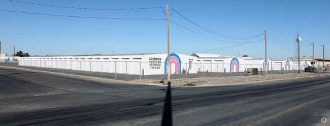

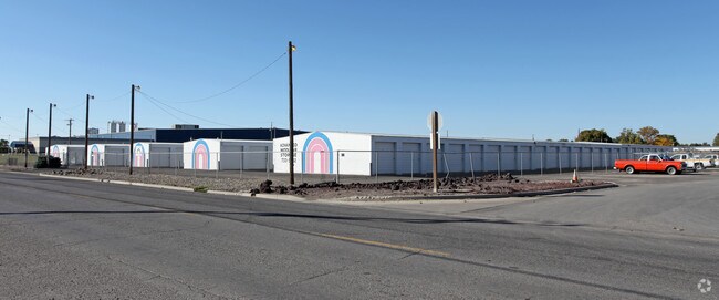
Property Detail
630 Eastland Dr S
RPT2481002028DA
TWIN FALLS HIGHLAND VIEW TRACT S12 LOT 28 BLOCK 2 (22-10-17 SE)
Warehouse
Twin Falls
M-2
Idaho
B and X Area of moderate flood hazard, usually the area between the limits of the 100-year and 500-year floods.
28
2025
2.24 AC
2025
Idaho South Area
001002
Other Market Areas
9,440 SF
Twin Falls, ID
NEARBY LISTINGS FOR SALE OR LEASE
-
-
View all Twin Falls listings for sale on LoopNet.com
DEMOGRAPHICS near 630 Eastland Dr S
1 mile
3 mile
5 mile
2025 Total Population
1,114
39,289
69,185
2030 Population
1,164
41,296
73,039
Pop Growth 2025-2030
+ 4.49%
+ 5.11%
+ 5.57%
Average Age
35
38
38
2025 Total Households
434
14,796
25,284
HH Growth 2025-2030
+ 4.38%
+ 5.18%
+ 5.66%
Median Household Inc
$49,942
$64,606
$66,963
Avg Household Size
2.50
2.60
2.60
2025 Avg HH Vehicles
2.00
2.00
2.00
Median Home Value
$290,322
$316,384
$331,203
Median Year Built
1989
1978
1986
Nearby Places
Map Layers
Map Styles
 Street
 Aerial
Transit
 Traffic
 Biking
Places
Listings with unknown addresses are not visible on the map
- Restaurants
- Banks
- Shops
- Fitness
- Groceries
Nearby Properties
Address
Land Use
TOTAL SIZE
Lot Size
Zoning
Address
Land Use
TOTAL SIZE
Lot Size
Zoning
917,616 SF
143.88 AC
M-2
Address
Land Use
TOTAL SIZE
Lot Size
Zoning
259,424 SF
89.44 AC
M-2
Address
Land Use
TOTAL SIZE
Lot Size
Zoning
6,384 SF
5.89 AC
M-2
Address
Land Use
TOTAL SIZE
Lot Size
Zoning
382,261 SF
11.44 AC
M-2
Address
Land Use
TOTAL SIZE
Lot Size
Zoning
57,683 SF
36.64 AC
Address
Land Use
TOTAL SIZE
Lot Size
Zoning
167,708 SF
14.90 AC
C-1
Address
Land Use
TOTAL SIZE
Lot Size
Zoning
240,740 SF
6.74 AC
M-2
Address
Land Use
TOTAL SIZE
Lot Size
Zoning
9,440 SF
7.05 AC
R-6
Address
Land Use
TOTAL SIZE
Lot Size
Zoning
127,520 SF
16.82 AC
M-2
Address
Land Use
TOTAL SIZE
Lot Size
Zoning
40,730 SF
0.36 AC
O-T
Address
Land Use
TOTAL SIZE
Lot Size
Zoning
78,849 SF
18.66 AC
M-2
Address
Land Use
TOTAL SIZE
Lot Size
Zoning
29,988 SF
3.80 AC
Address
Land Use
TOTAL SIZE
Lot Size
Zoning
233,304 SF
6.01 AC
M-2
Address
Land Use
TOTAL SIZE
Lot Size
Zoning
94,366 SF
9.85 AC
M-2
Address
Land Use
TOTAL SIZE
Lot Size
Zoning
52,095 SF
0.22 AC
C-B
Address
Land Use
TOTAL SIZE
Lot Size
Zoning
88,314 SF
8.15 AC
C-1
Address
Land Use
TOTAL SIZE
Lot Size
Zoning
46,122 SF
6.37 AC
R-6
Address
Land Use
TOTAL SIZE
Lot Size
Zoning
10,536 SF
3.07 AC
C-1
Address
Land Use
TOTAL SIZE
Lot Size
Zoning
74,375 SF
3.02 AC
M-2
Address
Land Use
TOTAL SIZE
Lot Size
Zoning
36,192 SF
0.34 AC
C-B
Address
Land Use
TOTAL SIZE
Lot Size
Zoning
157,403 SF
14.69 AC
M-1
Address
Land Use
TOTAL SIZE
Lot Size
Zoning
52,068 SF
0.86 AC
R-4
Address
Land Use
TOTAL SIZE
Lot Size
Zoning
14,913 SF
104.49 AC
M-2
Address
Land Use
TOTAL SIZE
Lot Size
Zoning
7,062 SF
3.62 AC
R-4
Address
Land Use
TOTAL SIZE
Lot Size
Zoning
19,286 SF
10.10 AC
C-1
Address
Land Use
TOTAL SIZE
Lot Size
Zoning
90,334 SF
8.14 AC
Address
Land Use
TOTAL SIZE
Lot Size
Zoning
5,906 SF
3.28 AC
R-4
Address
Land Use
TOTAL SIZE
Lot Size
Zoning
33,600 SF
0.94 AC
C-1
Address
Land Use
TOTAL SIZE
Lot Size
Zoning
236.96 AC
M-2
The World's #1 Commercial Real Estate Marketplace
Connect with us
© 2026 CoStar Group
The information above has been obtained from sources believed reliable. While we do not doubt its accuracy we have not verified it and make no guarantee, warranty or representation about it. It is your responsibility to independently confirm its accuracy and completeness. Any projections, opinions, assumptions, or estimates used are for example only and do not represent the current or future performance of the property. The value of this transaction to you depends on tax and other factors which should be evaluated by your tax, financial, and legal advisors. You and your advisors should conduct a careful, independent investigation of the property to determine to your satisfaction the suitability of the property for your needs.