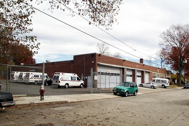
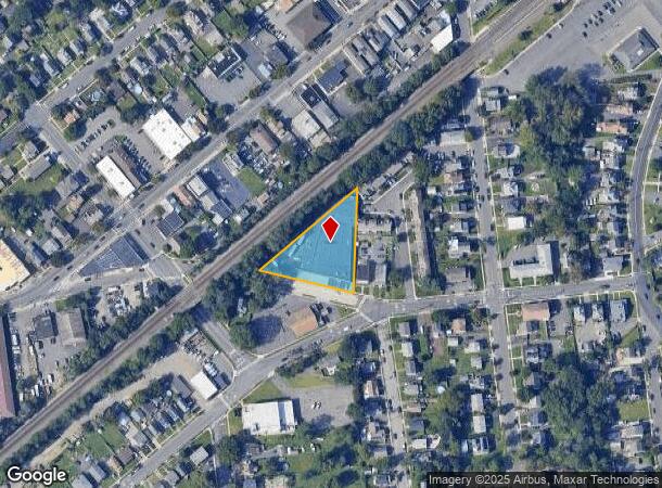
Property Record
630 Grove St, Dunellen, NJ 08812
NEARBY LISTINGS FOR SALE OR LEASE
Property Detail
630 Grove St
03-00068-0000-00013
265X282TRI
Warehouse
Middlesex
AE
New Jersey
34023C0029F
13
2024
1.72 AC
2025
Western Rt 287
000300
Northern New Jersey
23,000 SF
Lakewood-New Brunswick, NJ
DEMOGRAPHICS near 630 Grove St
1 mile
3 mile
5 mile
2024 Total Population
15,681
113,518
252,347
2029 Population
15,343
112,303
250,105
Pop Growth 2024-2029
(2.16%)
(1.07%)
(0.89%)
Average Age
39
39
39
2024 Total Households
5,103
36,567
82,547
HH Growth 2024-2029
(2.27%)
(1.03%)
(0.91%)
Median Household Inc
$89,105
$95,619
$102,204
Avg Household Size
3.00
2.90
2.90
2024 Avg HH Vehicles
2.00
2.00
2.00
Median Home Value
$348,317
$365,944
$395,945
Median Year Built
1955
1962
1965
Nearby Places
Map Layers
Map Styles
 Street
 Aerial
Transit
 Traffic
 Biking
Places
Listings with unknown addresses are not visible on the map
- Restaurants
- Banks
- Shops
- Fitness
- Groceries
PUBLIC TRANSPORTATION
TRANSIT/SUBWAY
Dunellen (Raritan Valley Line - NJ Transit Commuter Rail (NJ Transit))
Drive
Walk
Distance
Dunellen (Raritan Valley Line - NJ Transit Commuter Rail (NJ Transit))
1 min
6 min
0.3 mi
COMMUTER RAIL
Dunellen (Raritan Valley Line - NJ Transit Commuter Rail (NJ Transit))
Drive
Walk
Distance
Dunellen (Raritan Valley Line - NJ Transit Commuter Rail (NJ Transit))
1 min
6 min
0.3 mi
Plainfield (Raritan Valley Line - NJ Transit Commuter Rail (NJ Transit))
Drive
Walk
Distance
Plainfield (Raritan Valley Line - NJ Transit Commuter Rail (NJ Transit))
8 min
3.4 mi
AIRPORT
Newark Liberty International
Drive
Walk
Distance
Newark Liberty International
36 min
24.3 mi
Trenton Mercer
Drive
Walk
Distance
Trenton Mercer
58 min
37.0 mi
LaGuardia
Drive
Walk
Distance
LaGuardia
70 min
43.5 mi
Freight Ports
Maher Terminal
Drive
Walk
Distance
Maher Terminal
40 min
22.9 mi
SALE & LEASE HISTORY
LISTING DATE
SALE/LEASE

Nov 28, 2017
For Sale
Nearby Properties
Address
Land Use
TOTAL SIZE
Lot Size
Zoning
Address
Land Use
TOTAL SIZE
Lot Size
Zoning
27.46 AC
LI5
Address
Land Use
TOTAL SIZE
Lot Size
Zoning
31.49 AC
LI5
Address
Land Use
TOTAL SIZE
Lot Size
Zoning
24.12 AC
LI5
Address
Land Use
TOTAL SIZE
Lot Size
Zoning
24.62 AC
R20
Address
Land Use
TOTAL SIZE
Lot Size
Zoning
41.40 AC
LI5
Address
Land Use
TOTAL SIZE
Lot Size
Zoning
17.01 AC
RM
Address
Land Use
TOTAL SIZE
Lot Size
Zoning
64.99 AC
LI5
Address
Land Use
TOTAL SIZE
Lot Size
Zoning
17.64 AC
R10A
Address
Land Use
TOTAL SIZE
Lot Size
Zoning
27.51 AC
RM
Address
Land Use
TOTAL SIZE
Lot Size
Zoning
12.57 AC
RM
Address
Land Use
TOTAL SIZE
Lot Size
Zoning
38.04 AC
RM
Address
Land Use
TOTAL SIZE
Lot Size
Zoning
21.60 AC
LI5
Address
Land Use
TOTAL SIZE
Lot Size
Zoning
23.94 AC
M2
Address
Land Use
TOTAL SIZE
Lot Size
Zoning
48.79 AC
SC
Address
Land Use
TOTAL SIZE
Lot Size
Zoning
10.09 AC
Address
Land Use
TOTAL SIZE
Lot Size
Zoning
38.35 AC
ER
Address
Land Use
TOTAL SIZE
Lot Size
Zoning
27.70 AC
Address
Land Use
TOTAL SIZE
Lot Size
Zoning
230,022 SF
15.48 AC
LI5
Address
Land Use
TOTAL SIZE
Lot Size
Zoning
16.75 AC
LI5
Address
Land Use
TOTAL SIZE
Lot Size
Zoning
17.21 AC
L15
Address
Land Use
TOTAL SIZE
Lot Size
Zoning
275,431 SF
17.91 AC
LI5
Address
Land Use
TOTAL SIZE
Lot Size
Zoning
19.81 AC
M2
Address
Land Use
TOTAL SIZE
Lot Size
Zoning
16.21 AC
RM
Address
Land Use
TOTAL SIZE
Lot Size
Zoning
63.87 AC
LI5
Address
Land Use
TOTAL SIZE
Lot Size
Zoning
19.90 AC
IND
Address
Land Use
TOTAL SIZE
Lot Size
Zoning
254,656 SF
16.53 AC
LI5
Address
Land Use
TOTAL SIZE
Lot Size
Zoning
214,683 SF
13.38 AC
LI5
Address
Land Use
TOTAL SIZE
Lot Size
Zoning
18.31 AC
LI5
Address
Land Use
TOTAL SIZE
Lot Size
Zoning
25.74 AC
LI5
Address
Land Use
TOTAL SIZE
Lot Size
Zoning
233,217 SF
36.91 AC
LI5
The World's #1 Commercial Real Estate Marketplace
Connect with us
© 2026 CoStar Group
The information above has been obtained from sources believed reliable. While we do not doubt its accuracy we have not verified it and make no guarantee, warranty or representation about it. It is your responsibility to independently confirm its accuracy and completeness. Any projections, opinions, assumptions, or estimates used are for example only and do not represent the current or future performance of the property. The value of this transaction to you depends on tax and other factors which should be evaluated by your tax, financial, and legal advisors. You and your advisors should conduct a careful, independent investigation of the property to determine to your satisfaction the suitability of the property for your needs.