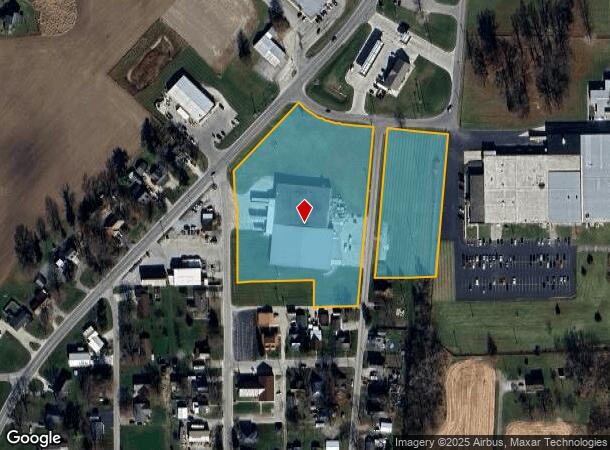
Property Record
630 High St, Geneva, IN 46740
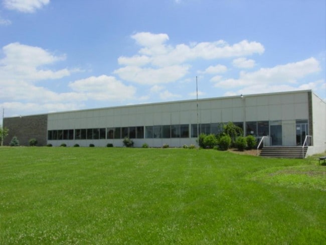
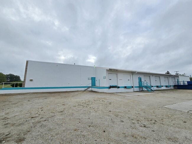
This Property Is For Sale
NEARBY LISTINGS FOR SALE OR LEASE
-
-
View all Geneva listings for sale on LoopNet.com
Property Detail
630 High St
01-11-29-200-049.000-019
PT NE NE BET HIGH ST & RR SEC 29
Warehouse
Adams
X
Indiana
18075C0055B
5.94 AC
2024
Fort Wayne
2024
Other Market Areas
030700
Decatur, IN
43,150 SF
DEMOGRAPHICS near 630 High St
1 Mile
3 Mile
5 Mile
2024 Total Population
1,526
2,509
10,094
2029 Population
1,566
2,565
10,333
Pop Growth 2024-2029
+ 2.62%
+ 2.23%
+ 2.37%
Average Age
41
38
36
2024 Total Households
649
911
3,399
HH Growth 2024-2029
+ 2.47%
+ 2.20%
+ 2.44%
Median Household Inc
$49,827
$53,538
$58,059
Avg Household Size
2.20
2.50
2.70
2024 Avg HH Vehicles
2.00
2.00
2.00
Median Home Value
$126,785
$161,306
$166,412
Median Year Built
1971
1972
1975
Nearby Places
Map Layers
Map Styles
 Street
 Aerial
- Restaurants
- Banks
- Shops
- Fitness
- Groceries
PUBLIC TRANSPORTATION
AIRPORT
Fort Wayne International
DRIVE
WALK
Distance
Fort Wayne International
64 min
40.3 mi
Nearby Properties
Address
Land Use
TOTAL SIZE
Lot Size
Zoning
Address
Land Use
TOTAL SIZE
Lot Size
Zoning
124.86 AC
Address
Land Use
TOTAL SIZE
Lot Size
Zoning
425,409 SF
18.79 AC
I1
Address
Land Use
TOTAL SIZE
Lot Size
Zoning
252,152 SF
13.44 AC
I1
Address
Land Use
TOTAL SIZE
Lot Size
Zoning
480 SF
2.69 AC
I1
Address
Land Use
TOTAL SIZE
Lot Size
Zoning
96,144 SF
8.40 AC
I1
Address
Land Use
TOTAL SIZE
Lot Size
Zoning
9,130 SF
1.58 AC
R1
Address
Land Use
TOTAL SIZE
Lot Size
Zoning
220.80 AC
Address
Land Use
TOTAL SIZE
Lot Size
Zoning
3,315 SF
1.74 AC
I1
Address
Land Use
TOTAL SIZE
Lot Size
Zoning
21,942 SF
12.77 AC
Address
Land Use
TOTAL SIZE
Lot Size
Zoning
39,275 SF
2.80 AC
I1
Address
Land Use
TOTAL SIZE
Lot Size
Zoning
6,358 SF
0.40 AC
B3
Address
Land Use
TOTAL SIZE
Lot Size
Zoning
4,849 SF
1.99 AC
Address
Land Use
TOTAL SIZE
Lot Size
Zoning
17,812 SF
22.17 AC
Address
Land Use
TOTAL SIZE
Lot Size
Zoning
70 AC
Address
Land Use
TOTAL SIZE
Lot Size
Zoning
7,648 SF
0.40 AC
B3
Address
Land Use
TOTAL SIZE
Lot Size
Zoning
2,480 SF
83.60 AC
R1
Address
Land Use
TOTAL SIZE
Lot Size
Zoning
2,976 SF
1.20 AC
R2
Address
Land Use
TOTAL SIZE
Lot Size
Zoning
2,001 SF
80.35 AC
Address
Land Use
TOTAL SIZE
Lot Size
Zoning
264 SF
5.40 AC
I1
Address
Land Use
TOTAL SIZE
Lot Size
Zoning
150.55 AC
Address
Land Use
TOTAL SIZE
Lot Size
Zoning
22,400 SF
2.11 AC
I1
Address
Land Use
TOTAL SIZE
Lot Size
Zoning
71.01 AC
Address
Land Use
TOTAL SIZE
Lot Size
Zoning
4,636 SF
2.24 AC
R2
Address
Land Use
TOTAL SIZE
Lot Size
Zoning
141.03 AC
Address
Land Use
TOTAL SIZE
Lot Size
Zoning
7,611 SF
1.96 AC
R1
Address
Land Use
TOTAL SIZE
Lot Size
Zoning
191.91 AC
Address
Land Use
TOTAL SIZE
Lot Size
Zoning
3,712 SF
0.18 AC
R1
Address
Land Use
TOTAL SIZE
Lot Size
Zoning
140.02 AC
Address
Land Use
TOTAL SIZE
Lot Size
Zoning
114 AC
The World's #1 Commercial Real Estate Marketplace
Connect with us
© 2026 CoStar Group
The information above has been obtained from sources believed reliable. While we do not doubt its accuracy we have not verified it and make no guarantee, warranty or representation about it. It is your responsibility to independently confirm its accuracy and completeness. Any projections, opinions, assumptions, or estimates used are for example only and do not represent the current or future performance of the property. The value of this transaction to you depends on tax and other factors which should be evaluated by your tax, financial, and legal advisors. You and your advisors should conduct a careful, independent investigation of the property to determine to your satisfaction the suitability of the property for your needs.