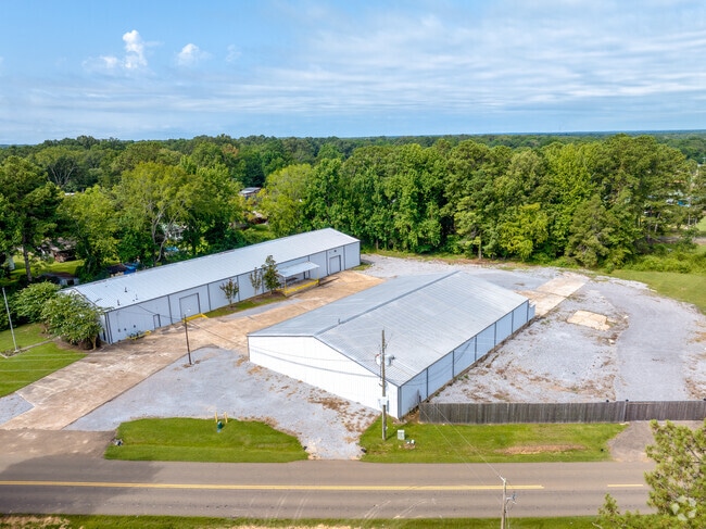
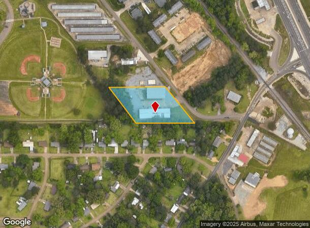
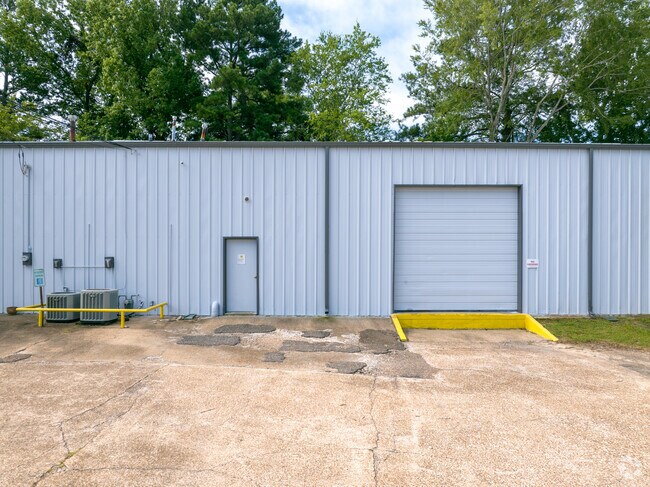
Property Record
620 Industrial Dr, Richland, MS 39218
NEARBY LISTINGS FOR SALE OR LEASE
Property Detail
620 Industrial Dr
D06G-000021-00000
LOT 302.06 X 369.63 X 311.64 X 384.73 IN NW4 DB 363 PG 325 0032078
Warehouse
Rankin
X
Mississippi
28121C0309F
2.60 AC
2024
Outlying Rankin County
2024
Jackson
020401
Jackson, MS
12,426 SF
DEMOGRAPHICS near 620 Industrial Dr
1 Mile
3 Mile
5 Mile
2024 Total Population
4,706
11,474
35,536
2029 Population
4,857
11,875
36,367
Pop Growth 2024-2029
+ 3.21%
+ 3.49%
+ 2.34%
Average Age
37
39
39
2024 Total Households
1,740
4,324
12,491
HH Growth 2024-2029
+ 3.22%
+ 3.58%
+ 2.52%
Median Household Inc
$54,012
$52,211
$50,383
Avg Household Size
2.70
2.60
2.50
2024 Avg HH Vehicles
2.00
2.00
2.00
Median Home Value
$103,936
$139,928
$145,229
Median Year Built
1993
1992
1986
Nearby Places
Map Layers
Map Styles
 Street
 Aerial
- Restaurants
- Banks
- Shops
- Fitness
- Groceries
PUBLIC TRANSPORTATION
COMMUTER RAIL
Jackson (City of New Orleans - Amtrak)
DRIVE
WALK
Distance
Jackson (City of New Orleans - Amtrak)
13 min
8.9 mi
AIRPORT
Jackson-Medgar Wiley Evers International
DRIVE
WALK
Distance
Jackson-Medgar Wiley Evers International
20 min
12.9 mi
Freight Ports
Port of Greater Baton Rouge
DRIVE
WALK
Distance
Port of Greater Baton Rouge
203 min
181.7 mi
SALE & LEASE HISTORY
LISTING DATE
SALE/LEASE

Jan 03, 2023
For Lease
Apr 11, 2024
For Sale
Nearby Properties
Address
Land Use
TOTAL SIZE
Lot Size
Zoning
Address
Land Use
TOTAL SIZE
Lot Size
Zoning
58.94 AC
Address
Land Use
TOTAL SIZE
Lot Size
Zoning
157,034 SF
17.28 AC
Address
Land Use
TOTAL SIZE
Lot Size
Zoning
7,840 SF
10.34 AC
Address
Land Use
TOTAL SIZE
Lot Size
Zoning
24,081 SF
24.48 AC
Address
Land Use
TOTAL SIZE
Lot Size
Zoning
11,796 SF
2.97 AC
Address
Land Use
TOTAL SIZE
Lot Size
Zoning
2,513 SF
7.10 AC
Address
Land Use
TOTAL SIZE
Lot Size
Zoning
7,648 SF
7.10 AC
Address
Land Use
TOTAL SIZE
Lot Size
Zoning
16,095 SF
11.11 AC
Address
Land Use
TOTAL SIZE
Lot Size
Zoning
5,595 SF
7.51 AC
Address
Land Use
TOTAL SIZE
Lot Size
Zoning
12.74 AC
Address
Land Use
TOTAL SIZE
Lot Size
Zoning
9,789 SF
23.22 AC
Address
Land Use
TOTAL SIZE
Lot Size
Zoning
59,724 SF
7.95 AC
Address
Land Use
TOTAL SIZE
Lot Size
Zoning
24,864 SF
6.10 AC
Address
Land Use
TOTAL SIZE
Lot Size
Zoning
120,296 SF
6.02 AC
Address
Land Use
TOTAL SIZE
Lot Size
Zoning
38,621 SF
1.88 AC
Address
Land Use
TOTAL SIZE
Lot Size
Zoning
34,329 SF
3 AC
Address
Land Use
TOTAL SIZE
Lot Size
Zoning
1.12 AC
Address
Land Use
TOTAL SIZE
Lot Size
Zoning
981 SF
6 AC
Address
Land Use
TOTAL SIZE
Lot Size
Zoning
4,810 SF
28.82 AC
Address
Land Use
TOTAL SIZE
Lot Size
Zoning
23,479 SF
4 AC
Address
Land Use
TOTAL SIZE
Lot Size
Zoning
42,442 SF
30 AC
Address
Land Use
TOTAL SIZE
Lot Size
Zoning
22,786 SF
11.92 AC
Address
Land Use
TOTAL SIZE
Lot Size
Zoning
5,150 SF
5.71 AC
Address
Land Use
TOTAL SIZE
Lot Size
Zoning
46,866 SF
10 AC
Address
Land Use
TOTAL SIZE
Lot Size
Zoning
43,545 SF
9.17 AC
Address
Land Use
TOTAL SIZE
Lot Size
Zoning
36,414 SF
6.10 AC
Address
Land Use
TOTAL SIZE
Lot Size
Zoning
13,517 SF
2.05 AC
Address
Land Use
TOTAL SIZE
Lot Size
Zoning
5,257 SF
0.92 AC
Address
Land Use
TOTAL SIZE
Lot Size
Zoning
56,761 SF
1.38 AC
Address
Land Use
TOTAL SIZE
Lot Size
Zoning
19,230 SF
3.06 AC
The World's #1 Commercial Real Estate Marketplace
Connect with us
© 2025 CoStar Group
The information above has been obtained from sources believed reliable. While we do not doubt its accuracy we have not verified it and make no guarantee, warranty or representation about it. It is your responsibility to independently confirm its accuracy and completeness. Any projections, opinions, assumptions, or estimates used are for example only and do not represent the current or future performance of the property. The value of this transaction to you depends on tax and other factors which should be evaluated by your tax, financial, and legal advisors. You and your advisors should conduct a careful, independent investigation of the property to determine to your satisfaction the suitability of the property for your needs.