Property Record
630 N Wayne St, Milledgeville, GA 31061
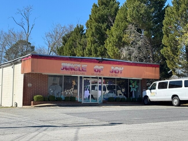

This Property Is For Sale
NEARBY LISTINGS FOR SALE OR LEASE
Property Detail
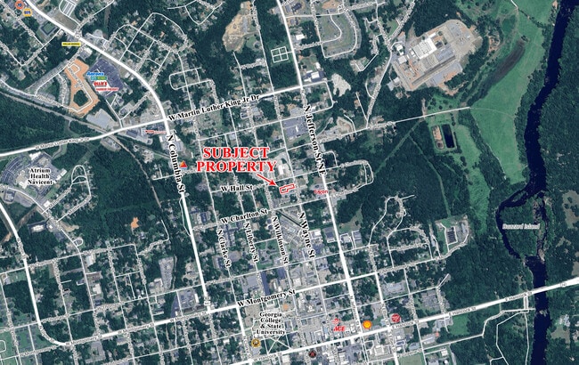
630 N Wayne St
M81-003
Comm-Wayne St-Area 3
Publicstorage
W/S N WAYNE ST DB 1059-413 PLAT DB 84-344
X
Baldwin
13319C0025C
Georgia
2025
0.68 AC
2025
Georgia South Area
970400
Other Market Areas
5,174 SF
Milledgeville, GA
DEMOGRAPHICS near 630 N Wayne St
1 Mile
3 Mile
5 Mile
2024 Total Population
5,841
20,269
28,279
2029 Population
6,017
20,377
28,274
Pop Growth 2024-2029
+ 3.01%
+ 0.53%
(0.02%)
Average Age
32
37
39
2024 Total Households
2,341
8,023
11,011
HH Growth 2024-2029
+ 3.37%
+ 0.51%
(0.04%)
Median Household Inc
$17,879
$35,203
$41,776
Avg Household Size
2.10
2.20
2.30
2024 Avg HH Vehicles
2.00
2.00
2.00
Median Home Value
$133,701
$142,927
$157,942
Median Year Built
1974
1978
1981
Nearby Places
Map Layers
Map Styles
 Street
 Aerial
- Restaurants
- Banks
- Shops
- Fitness
- Groceries
Nearby Properties
Address
Land Use
TOTAL SIZE
Lot Size
Zoning
Address
Land Use
TOTAL SIZE
Lot Size
Zoning
19.20 AC
RESIDENTIA
Address
Land Use
TOTAL SIZE
Lot Size
Zoning
29.65 AC
RESIDENTIA
Address
Land Use
TOTAL SIZE
Lot Size
Zoning
102,300 SF
66.81 AC
UNZONED RU
Address
Land Use
TOTAL SIZE
Lot Size
Zoning
5,378 SF
1,875.54 AC
RESIDENTIA
Address
Land Use
TOTAL SIZE
Lot Size
Zoning
31,112 SF
13.98 AC
RESIDENTIA
Address
Land Use
TOTAL SIZE
Lot Size
Zoning
430,556 SF
32.09 AC
RESIDENTIA
Address
Land Use
TOTAL SIZE
Lot Size
Zoning
74,448 SF
49 AC
RESIDENTIA
Address
Land Use
TOTAL SIZE
Lot Size
Zoning
118,521 SF
1.86 AC
RESIDENTIA
Address
Land Use
TOTAL SIZE
Lot Size
Zoning
34,953 SF
2.17 AC
RESIDENTIA
Address
Land Use
TOTAL SIZE
Lot Size
Zoning
2.50 AC
RESIDENTIA
Address
Land Use
TOTAL SIZE
Lot Size
Zoning
49,412 SF
0.26 AC
RESIDENTIA
Address
Land Use
TOTAL SIZE
Lot Size
Zoning
313,804 SF
17.50 AC
RESIDENTIA
Address
Land Use
TOTAL SIZE
Lot Size
Zoning
386,880 SF
17.52 AC
RESIDENTIA
Address
Land Use
TOTAL SIZE
Lot Size
Zoning
67,500 SF
1.70 AC
RESIDENTIA
Address
Land Use
TOTAL SIZE
Lot Size
Zoning
30.05 AC
RESIDENTIA
Address
Land Use
TOTAL SIZE
Lot Size
Zoning
866,082 SF
6.61 AC
RESIDENTIA
Address
Land Use
TOTAL SIZE
Lot Size
Zoning
40,800 SF
0.14 AC
RESIDENTIA
Address
Land Use
TOTAL SIZE
Lot Size
Zoning
12.30 AC
RESIDENTIA
Address
Land Use
TOTAL SIZE
Lot Size
Zoning
228,844 SF
3.20 AC
RESIDENTIA
Address
Land Use
TOTAL SIZE
Lot Size
Zoning
554,286 SF
24.17 AC
RESIDENTIA
Address
Land Use
TOTAL SIZE
Lot Size
Zoning
19.50 AC
RESIDENTIA
Address
Land Use
TOTAL SIZE
Lot Size
Zoning
139,950 SF
27.92 AC
RESIDENTIA
Address
Land Use
TOTAL SIZE
Lot Size
Zoning
46,858 SF
2.64 AC
RESIDENTIA
Address
Land Use
TOTAL SIZE
Lot Size
Zoning
50,580 SF
7.61 AC
COMMERCIAL
Address
Land Use
TOTAL SIZE
Lot Size
Zoning
76,582 SF
3.17 AC
RESIDENTIA
Address
Land Use
TOTAL SIZE
Lot Size
Zoning
37,296 SF
13.50 AC
RESIDENTIA
Address
Land Use
TOTAL SIZE
Lot Size
Zoning
71,162 SF
2.30 AC
COMMERCIAL
Address
Land Use
TOTAL SIZE
Lot Size
Zoning
160,604 SF
8.29 AC
RESIDENTIA
Address
Land Use
TOTAL SIZE
Lot Size
Zoning
1,200 SF
10 AC
UNZONED RU
Address
Land Use
TOTAL SIZE
Lot Size
Zoning
172,008 SF
2.31 AC
RESIDENTIA
The World's #1 Commercial Real Estate Marketplace
Connect with us
© 2025 CoStar Group
The information above has been obtained from sources believed reliable. While we do not doubt its accuracy we have not verified it and make no guarantee, warranty or representation about it. It is your responsibility to independently confirm its accuracy and completeness. Any projections, opinions, assumptions, or estimates used are for example only and do not represent the current or future performance of the property. The value of this transaction to you depends on tax and other factors which should be evaluated by your tax, financial, and legal advisors. You and your advisors should conduct a careful, independent investigation of the property to determine to your satisfaction the suitability of the property for your needs.