Property Record
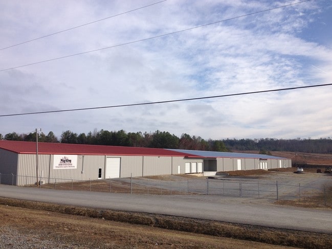
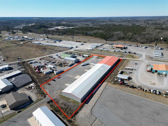
80 Campbell Dr, Hanceville, AL 35077

This Property Is For Sale
Property Detail
80 Campbell Dr
22-08-28-0-000-002.010
3.89 AC - COMM INT N/LN NE1/4 NW1/4 & W/ROW CHIGGER RIDGE RD W 240(S) TO POB, CONT W 695.69, S 265, E 582.26, NE 343.12 TO PO
Warehouse
CULLMAN
B and X Area of moderate flood hazard, usually the area between the limits of the 100-year and 500-year floods.
Alabama
2025
3.89 AC
2025
Alabama North Area
965401
Other Market Areas
56,600 SF
Cullman, AL
NEARBY LISTINGS FOR SALE OR LEASE
-
-
View all Hanceville listings for sale on LoopNet.com
DEMOGRAPHICS near 80 Campbell Dr
1 mile
3 mile
5 mile
2025 Total Population
174
2,644
10,549
2030 Population
179
2,742
10,956
Pop Growth 2025-2030
+ 2.87%
+ 3.71%
+ 3.86%
Average Age
43
40
41
2025 Total Households
69
1,020
4,047
HH Growth 2025-2030
+ 2.90%
+ 3.63%
+ 3.90%
Median Household Inc
$82,143
$82,337
$73,535
Avg Household Size
2.50
2.50
2.50
2025 Avg HH Vehicles
2.00
2.00
2.00
Median Home Value
$192,307
$190,765
$215,378
Median Year Built
1982
1982
1985
Nearby Places
Map Layers
Map Styles
 Street
 Aerial
Layers
 Traffic
 Biking
Places
Listings with unknown addresses are not visible on the map
- Restaurants
- Banks
- Shops
- Fitness
- Groceries
Nearby Properties
Address
Land Use
TOTAL SIZE
Lot Size
Zoning
Address
Land Use
TOTAL SIZE
Lot Size
Zoning
33,001 SF
4.58 AC
Address
Land Use
TOTAL SIZE
Lot Size
Zoning
40,000 SF
27 AC
Address
Land Use
TOTAL SIZE
Lot Size
Zoning
30,000 SF
4 AC
Address
Land Use
TOTAL SIZE
Lot Size
Zoning
4,726 SF
17.30 AC
Address
Land Use
TOTAL SIZE
Lot Size
Zoning
7,160 SF
2.82 AC
Address
Land Use
TOTAL SIZE
Lot Size
Zoning
17,040 SF
9.34 AC
Address
Land Use
TOTAL SIZE
Lot Size
Zoning
23,605 SF
3 AC
Address
Land Use
TOTAL SIZE
Lot Size
Zoning
2,884 SF
0.76 AC
Address
Land Use
TOTAL SIZE
Lot Size
Zoning
35,904 SF
12.60 AC
Address
Land Use
TOTAL SIZE
Lot Size
Zoning
13,500 SF
1.10 AC
Address
Land Use
TOTAL SIZE
Lot Size
Zoning
11,172 SF
6.50 AC
Address
Land Use
TOTAL SIZE
Lot Size
Zoning
2,565 SF
0.90 AC
Address
Land Use
TOTAL SIZE
Lot Size
Zoning
8,132 SF
4.39 AC
Address
Land Use
TOTAL SIZE
Lot Size
Zoning
10,410 SF
58 AC
Address
Land Use
TOTAL SIZE
Lot Size
Zoning
10,800 SF
3.10 AC
Address
Land Use
TOTAL SIZE
Lot Size
Zoning
7,440 SF
11.03 AC
Address
Land Use
TOTAL SIZE
Lot Size
Zoning
400 SF
2.04 AC
Address
Land Use
TOTAL SIZE
Lot Size
Zoning
9,200 SF
9.18 AC
Address
Land Use
TOTAL SIZE
Lot Size
Zoning
4,850 SF
1 AC
Address
Land Use
TOTAL SIZE
Lot Size
Zoning
16,000 SF
10 AC
Address
Land Use
TOTAL SIZE
Lot Size
Zoning
15,000 SF
14 AC
Address
Land Use
TOTAL SIZE
Lot Size
Zoning
2,634 SF
1.45 AC
Address
Land Use
TOTAL SIZE
Lot Size
Zoning
1,758 SF
18 AC
Address
Land Use
TOTAL SIZE
Lot Size
Zoning
1,500 SF
91 AC
Address
Land Use
TOTAL SIZE
Lot Size
Zoning
3,000 SF
32 AC
Address
Land Use
TOTAL SIZE
Lot Size
Zoning
7,920 SF
1.89 AC
Address
Land Use
TOTAL SIZE
Lot Size
Zoning
5,712 SF
6.70 AC
Address
Land Use
TOTAL SIZE
Lot Size
Zoning
Address
Land Use
TOTAL SIZE
Lot Size
Zoning
8,000 SF
1.60 AC
The World's #1 Commercial Real Estate Marketplace
Connect with us
© 2026 CoStar Group
The information above has been obtained from sources believed reliable. While we do not doubt its accuracy we have not verified it and make no guarantee, warranty or representation about it. It is your responsibility to independently confirm its accuracy and completeness. Any projections, opinions, assumptions, or estimates used are for example only and do not represent the current or future performance of the property. The value of this transaction to you depends on tax and other factors which should be evaluated by your tax, financial, and legal advisors. You and your advisors should conduct a careful, independent investigation of the property to determine to your satisfaction the suitability of the property for your needs.