Property Record
6300 E Hampden Ave, Denver, CO 80222
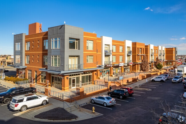


Property Detail
6300 E Hampden Ave
7052-00-047
T5 R67 S5 NW/4 PT BEG COR S LI E HAMPDEN AVE & E LI I-25 THE 540 S 588FT W 489.85FT NWLY 247.58FT WLY 5.25FT NWLY342.77FT TO POB
Retailwithmorethanonenonretailuse
DENVER
C-RX
Colorado
2024
6.99 AC
2025
Hampden
006815
Denver
508,135 SF
Denver-Aurora-Centennial, CO
NEARBY LISTINGS FOR SALE OR LEASE
DEMOGRAPHICS near 6300 E Hampden Ave
1 mile
3 mile
5 mile
2025 Total Population
13,770
134,911
379,471
2030 Population
13,850
137,853
387,186
Pop Growth 2025-2030
+ 0.58%
+ 2.18%
+ 2.03%
Average Age
43
40
41
2025 Total Households
6,238
62,554
172,530
HH Growth 2025-2030
+ 0.67%
+ 2.31%
+ 2.19%
Median Household Inc
$116,064
$86,160
$92,735
Avg Household Size
2.20
2.10
2.10
2025 Avg HH Vehicles
2.00
2.00
2.00
Median Home Value
$704,944
$719,687
$710,412
Median Year Built
1970
1978
1977
Nearby Places
Map Layers
Map Styles
 Street
 Aerial
Layers
 Traffic
 Biking
Places
Listings with unknown addresses are not visible on the map
- Restaurants
- Banks
- Shops
- Fitness
- Groceries
PUBLIC TRANSPORTATION
TRANSIT/SUBWAY
Southmoor (E Line - Denver Regional Transportation District Light Rail (TheRide), F Line - Denver Regional Transportation District Light Rail (TheRide), H Line - Denver Regional Transportation District Light Rail (TheRide))
Drive
Walk
Distance
Southmoor (E Line - Denver Regional Transportation District Light Rail (TheRide), F Line - Denver Regional Transportation District Light Rail (TheRide), H Line - Denver Regional Transportation District Light Rail (TheRide))
2 min
10 min
0.6 mi
COMMUTER RAIL
Central Park Station Track 1 (Union Station to Denver Airport Station - Regional Transportation District)
Drive
Walk
Distance
Central Park Station Track 1 (Union Station to Denver Airport Station - Regional Transportation District)
22 min
9.9 mi
AIRPORT
Denver International
Drive
Walk
Distance
Denver International
34 min
27.2 mi
Freight Ports
Tulsa Port Of Catoosa
Drive
Walk
Distance
Tulsa Port Of Catoosa
731 min
710.0 mi
SALE & LEASE HISTORY
LISTING DATE
SALE/LEASE

Jun 29, 2017
For Lease
Apr 09, 2019
For Lease
Nearby Properties
Address
Land Use
TOTAL SIZE
Lot Size
Zoning
Address
Land Use
TOTAL SIZE
Lot Size
Zoning
579,353 SF
3.26 AC
T-MU
Address
Land Use
TOTAL SIZE
Lot Size
Zoning
377,735 SF
1.72 AC
G-RX
Address
Land Use
TOTAL SIZE
Lot Size
Zoning
422,426 SF
1.05 AC
C-RX
Address
Land Use
TOTAL SIZE
Lot Size
Zoning
124,658 SF
2.13 AC
CMP-EI
Address
Land Use
TOTAL SIZE
Lot Size
Zoning
277,917 SF
12.59 AC
B-4
Address
Land Use
TOTAL SIZE
Lot Size
Zoning
470,605 SF
13.68 AC
B-8
Address
Land Use
TOTAL SIZE
Lot Size
Zoning
389,502 SF
2.32 AC
T-MU-30
Address
Land Use
TOTAL SIZE
Lot Size
Zoning
147,078 SF
6.17 AC
CMP-EI
Address
Land Use
TOTAL SIZE
Lot Size
Zoning
898,130 SF
89.50 AC
Address
Land Use
TOTAL SIZE
Lot Size
Zoning
331,620 SF
2.03 AC
T-MU-30
Address
Land Use
TOTAL SIZE
Lot Size
Zoning
109,980 SF
1.99 AC
Address
Land Use
TOTAL SIZE
Lot Size
Zoning
240,545 SF
2.35 AC
C-MX-20
Address
Land Use
TOTAL SIZE
Lot Size
Zoning
394,111 SF
0.91 AC
T-MU
Address
Land Use
TOTAL SIZE
Lot Size
Zoning
81,873 SF
0.32 AC
C-RX
Address
Land Use
TOTAL SIZE
Lot Size
Zoning
355,464 SF
6.20 AC
B-8
Address
Land Use
TOTAL SIZE
Lot Size
Zoning
416,096 SF
5.20 AC
C-MX-20
Address
Land Use
TOTAL SIZE
Lot Size
Zoning
320,589 SF
33.33 AC
S-SU-F
Address
Land Use
TOTAL SIZE
Lot Size
Zoning
14,878 SF
34.55 AC
OS-B
Address
Land Use
TOTAL SIZE
Lot Size
Zoning
313,836 SF
5.90 AC
B-8
Address
Land Use
TOTAL SIZE
Lot Size
Zoning
585,091 SF
5.42 AC
PUD
Address
Land Use
TOTAL SIZE
Lot Size
Zoning
372,593 SF
5.61 AC
S-MX-12
Address
Land Use
TOTAL SIZE
Lot Size
Zoning
249,331 SF
4.93 AC
B-8
Address
Land Use
TOTAL SIZE
Lot Size
Zoning
191,152 SF
1.26 AC
S-MX-12
Address
Land Use
TOTAL SIZE
Lot Size
Zoning
413,033 SF
4.33 AC
Address
Land Use
TOTAL SIZE
Lot Size
Zoning
231,867 SF
19.33 AC
S-MX-3A
Address
Land Use
TOTAL SIZE
Lot Size
Zoning
613,600 SF
29.40 AC
R-3
Address
Land Use
TOTAL SIZE
Lot Size
Zoning
158,805 SF
3.71 AC
CMP-EI
Address
Land Use
TOTAL SIZE
Lot Size
Zoning
40,268 SF
8.35 AC
S-SU-F
Address
Land Use
TOTAL SIZE
Lot Size
Zoning
396,041 SF
6.77 AC
B-8
The World's #1 Commercial Real Estate Marketplace
Connect with us
© 2026 CoStar Group
The information above has been obtained from sources believed reliable. While we do not doubt its accuracy we have not verified it and make no guarantee, warranty or representation about it. It is your responsibility to independently confirm its accuracy and completeness. Any projections, opinions, assumptions, or estimates used are for example only and do not represent the current or future performance of the property. The value of this transaction to you depends on tax and other factors which should be evaluated by your tax, financial, and legal advisors. You and your advisors should conduct a careful, independent investigation of the property to determine to your satisfaction the suitability of the property for your needs.