Property Record
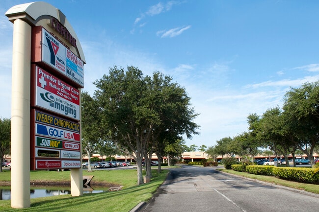
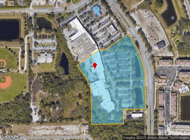
6300 N Wickham Rd, Melbourne, FL 32940
NEARBY LISTINGS FOR SALE OR LEASE
Property Detail
6300 N Wickham Rd
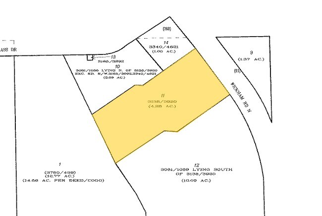
26-36-24-00-00012.0-0000.00
PART OF NE 1/4 OF NE 1/4 AS DESC IN ORB 3081 PG 1085 & ORB 3081 PG 1088 ALL LYING S OF ORB 3138 PG 3920 EXC ORB 3467 PG 2369 PAR 2
Storebuilding
Brevard
A
Florida
12009C0425G
11.49 AC
2024
Brevard County
2025
Orlando
064127
Palm Bay-Melbourne-Titusville, FL
82,494 SF
DEMOGRAPHICS near 6300 N Wickham Rd
1 Mile
3 Mile
5 Mile
2024 Total Population
4,349
33,526
93,544
2029 Population
4,870
36,510
102,709
Pop Growth 2024-2029
+ 11.98%
+ 8.90%
+ 9.80%
Average Age
53
47
46
2024 Total Households
2,033
14,055
39,931
HH Growth 2024-2029
+ 12.25%
+ 8.81%
+ 9.42%
Median Household Inc
$65,926
$95,375
$85,331
Avg Household Size
2.10
2.30
2.30
2024 Avg HH Vehicles
2.00
2.00
2.00
Median Home Value
$296,265
$352,232
$354,157
Median Year Built
1995
1995
1994
Nearby Places
Map Layers
Map Styles
 Street
 Aerial
- Restaurants
- Banks
- Shops
- Fitness
- Groceries
PUBLIC TRANSPORTATION
AIRPORT
Melbourne Orlando International
DRIVE
WALK
Distance
Melbourne Orlando International
24 min
11.0 mi
SALE & LEASE HISTORY
LISTING DATE
SALE/LEASE

Sep 08, 2023
For Lease
Sep 06, 2017
For Lease
Nov 05, 2025
For Lease
Nearby Properties
Address
Land Use
TOTAL SIZE
Lot Size
Zoning
Address
Land Use
TOTAL SIZE
Lot Size
Zoning
354,864 SF
26.76 AC
PIP
Address
Land Use
TOTAL SIZE
Lot Size
Zoning
406,986 SF
30.50 AC
PUD
Address
Land Use
TOTAL SIZE
Lot Size
Zoning
360,921 SF
85.76 AC
R2
Address
Land Use
TOTAL SIZE
Lot Size
Zoning
269,541 SF
17.80 AC
PUD
Address
Land Use
TOTAL SIZE
Lot Size
Zoning
134,562 SF
18.25 AC
BU1
Address
Land Use
TOTAL SIZE
Lot Size
Zoning
227,172 SF
26.78 AC
BU1
Address
Land Use
TOTAL SIZE
Lot Size
Zoning
113,498 SF
37.57 AC
PUD
Address
Land Use
TOTAL SIZE
Lot Size
Zoning
96,110 SF
49.65 AC
INH
Address
Land Use
TOTAL SIZE
Lot Size
Zoning
133,137 SF
10.59 AC
PUD
Address
Land Use
TOTAL SIZE
Lot Size
Zoning
102,972 SF
18 AC
R2(6)
Address
Land Use
TOTAL SIZE
Lot Size
Zoning
97,430 SF
51.89 AC
BU1
Address
Land Use
TOTAL SIZE
Lot Size
Zoning
170,721 SF
28.52 AC
PIP
Address
Land Use
TOTAL SIZE
Lot Size
Zoning
83,420 SF
5.94 AC
PUD
Address
Land Use
TOTAL SIZE
Lot Size
Zoning
91,470 SF
3.01 AC
BU1
Address
Land Use
TOTAL SIZE
Lot Size
Zoning
178,191 SF
18.19 AC
TU-2
Address
Land Use
TOTAL SIZE
Lot Size
Zoning
54,114 SF
11.48 AC
Address
Land Use
TOTAL SIZE
Lot Size
Zoning
120,600 SF
2.76 AC
Address
Land Use
TOTAL SIZE
Lot Size
Zoning
222,414 SF
13.13 AC
BU1
Address
Land Use
TOTAL SIZE
Lot Size
Zoning
51,042 SF
1.70 AC
TU-2
Address
Land Use
TOTAL SIZE
Lot Size
Zoning
67,313 SF
335.11 AC
PUD
Address
Land Use
TOTAL SIZE
Lot Size
Zoning
79,972 SF
7.20 AC
TU-2
Address
Land Use
TOTAL SIZE
Lot Size
Zoning
168,229 SF
20.36 AC
BU1/BU2
Address
Land Use
TOTAL SIZE
Lot Size
Zoning
2.61 AC
PUD
Address
Land Use
TOTAL SIZE
Lot Size
Zoning
73,100 SF
5.67 AC
C2
Address
Land Use
TOTAL SIZE
Lot Size
Zoning
128,415 SF
9.98 AC
BU2
Address
Land Use
TOTAL SIZE
Lot Size
Zoning
1.10 AC
BU-1
Address
Land Use
TOTAL SIZE
Lot Size
Zoning
62,431 SF
16.51 AC
BU-1
Address
Land Use
TOTAL SIZE
Lot Size
Zoning
94,217 SF
9.74 AC
PUD
Address
Land Use
TOTAL SIZE
Lot Size
Zoning
40,907 SF
5.52 AC
BU-1
The World's #1 Commercial Real Estate Marketplace
Connect with us
© 2026 CoStar Group
The information above has been obtained from sources believed reliable. While we do not doubt its accuracy we have not verified it and make no guarantee, warranty or representation about it. It is your responsibility to independently confirm its accuracy and completeness. Any projections, opinions, assumptions, or estimates used are for example only and do not represent the current or future performance of the property. The value of this transaction to you depends on tax and other factors which should be evaluated by your tax, financial, and legal advisors. You and your advisors should conduct a careful, independent investigation of the property to determine to your satisfaction the suitability of the property for your needs.