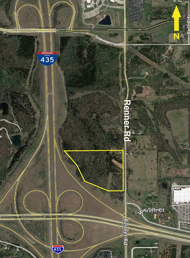
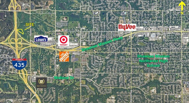
Property Record
6300 Renner Rd, Shawnee, KS 66217

NEARBY LISTINGS FOR SALE OR LEASE
Property Detail
6300 Renner Rd
QF241218-3002
18-12-24 BG NE CR NE1/4 W 1250.43 SE 421.81 S 378.60 SE 457.90 E 458.90 N 880 TOBG 18.546 ACS M/L SHC 595 1
Farms
Johnson
X
Kansas
20209C0145E
18.14 AC
2024
Northwest Johnson County
2024
Kansas City
052308
Kansas City, MO-KS
3,866 SF
DEMOGRAPHICS near 6300 Renner Rd
1 Mile
3 Mile
5 Mile
2024 Total Population
2,430
39,537
128,594
2029 Population
2,510
40,871
133,189
Pop Growth 2024-2029
+ 3.29%
+ 3.37%
+ 3.57%
Average Age
44
41
40
2024 Total Households
1,252
15,364
52,089
HH Growth 2024-2029
+ 3.51%
+ 3.40%
+ 3.74%
Median Household Inc
$65,168
$104,779
$87,355
Avg Household Size
1.90
2.50
2.40
2024 Avg HH Vehicles
2.00
2.00
2.00
Median Home Value
$332,143
$344,351
$297,894
Median Year Built
1994
1989
1985
Nearby Places
Map Layers
Map Styles
 Street
 Aerial
- Restaurants
- Banks
- Shops
- Fitness
- Groceries
PUBLIC TRANSPORTATION
AIRPORT
Kansas City International
DRIVE
WALK
Distance
Kansas City International
36 min
30.2 mi
Freight Ports
Tulsa Port Of Catoosa
DRIVE
WALK
Distance
Tulsa Port Of Catoosa
260 min
231.8 mi
SALE & LEASE HISTORY
LISTING DATE
SALE/LEASE

Apr 27, 2022
For Sale
Nearby Properties
Address
Land Use
TOTAL SIZE
Lot Size
Zoning
Address
Land Use
TOTAL SIZE
Lot Size
Zoning
202,842 SF
10.20 AC
PD
Address
Land Use
TOTAL SIZE
Lot Size
Zoning
83,537 SF
27.65 AC
AG
Address
Land Use
TOTAL SIZE
Lot Size
Zoning
141,340 SF
19.92 AC
R1
Address
Land Use
TOTAL SIZE
Lot Size
Zoning
75,010 SF
5.53 AC
PD
Address
Land Use
TOTAL SIZE
Lot Size
Zoning
274,379 SF
17.32 AC
Address
Land Use
TOTAL SIZE
Lot Size
Zoning
88,866 SF
21.54 AC
RS
Address
Land Use
TOTAL SIZE
Lot Size
Zoning
81,361 SF
3.81 AC
AG
Address
Land Use
TOTAL SIZE
Lot Size
Zoning
77,758 SF
4.89 AC
R-1
Address
Land Use
TOTAL SIZE
Lot Size
Zoning
35,848 SF
74.74 AC
R1
Address
Land Use
TOTAL SIZE
Lot Size
Zoning
34,641 SF
14.33 AC
AG
Address
Land Use
TOTAL SIZE
Lot Size
Zoning
42,603 SF
17.67 AC
AG
Address
Land Use
TOTAL SIZE
Lot Size
Zoning
285,041 SF
109.90 AC
EI1
Address
Land Use
TOTAL SIZE
Lot Size
Zoning
77,375 SF
9.22 AC
R-1
Address
Land Use
TOTAL SIZE
Lot Size
Zoning
152,721 SF
14.47 AC
PI
Address
Land Use
TOTAL SIZE
Lot Size
Zoning
63,754 SF
9.41 AC
R1
Address
Land Use
TOTAL SIZE
Lot Size
Zoning
203,515 SF
13.10 AC
CC
Address
Land Use
TOTAL SIZE
Lot Size
Zoning
69,451 SF
9.54 AC
R1
Address
Land Use
TOTAL SIZE
Lot Size
Zoning
30,025 SF
148.34 AC
AG
Address
Land Use
TOTAL SIZE
Lot Size
Zoning
52,710 SF
29.55 AC
AG
Address
Land Use
TOTAL SIZE
Lot Size
Zoning
46,850 SF
0.89 AC
PO
Address
Land Use
TOTAL SIZE
Lot Size
Zoning
376,094 SF
22.93 AC
Address
Land Use
TOTAL SIZE
Lot Size
Zoning
29,365 SF
20.45 AC
RP4
Address
Land Use
TOTAL SIZE
Lot Size
Zoning
235,783 SF
10.44 AC
619458
Address
Land Use
TOTAL SIZE
Lot Size
Zoning
164,864 SF
16.24 AC
CH
Address
Land Use
TOTAL SIZE
Lot Size
Zoning
22,616 SF
31.78 AC
AG
Address
Land Use
TOTAL SIZE
Lot Size
Zoning
59,640 SF
12.92 AC
PI
Address
Land Use
TOTAL SIZE
Lot Size
Zoning
13,871 SF
4.81 AC
AG
Address
Land Use
TOTAL SIZE
Lot Size
Zoning
102,591 SF
27.08 AC
RP4
Address
Land Use
TOTAL SIZE
Lot Size
Zoning
26,540 SF
2.30 AC
CN
Address
Land Use
TOTAL SIZE
Lot Size
Zoning
137,046 SF
16.32 AC
CH
The World's #1 Commercial Real Estate Marketplace
Connect with us
© 2026 CoStar Group
The information above has been obtained from sources believed reliable. While we do not doubt its accuracy we have not verified it and make no guarantee, warranty or representation about it. It is your responsibility to independently confirm its accuracy and completeness. Any projections, opinions, assumptions, or estimates used are for example only and do not represent the current or future performance of the property. The value of this transaction to you depends on tax and other factors which should be evaluated by your tax, financial, and legal advisors. You and your advisors should conduct a careful, independent investigation of the property to determine to your satisfaction the suitability of the property for your needs.