Property Record
6301 Castle Hayne Rd, Castle Hayne, NC 28429
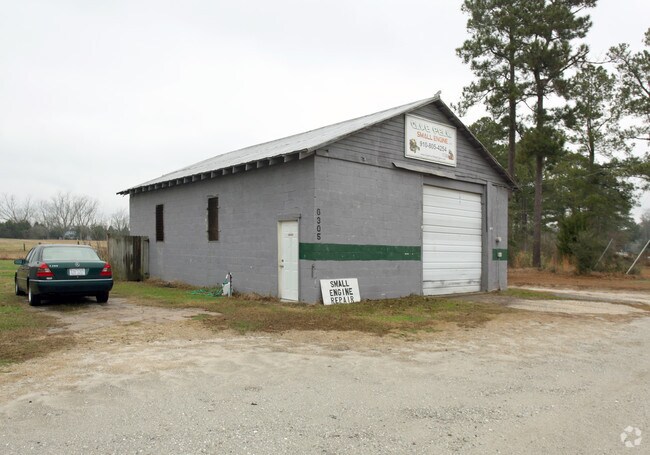

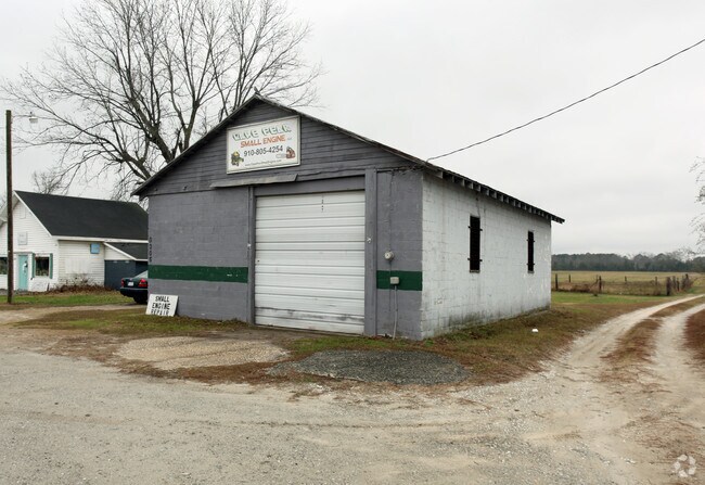
Property Detail
6301 Castle Hayne Rd
R01100-018-007-000
PT TR 1R-A REEVES DIVISION
Storebuilding
New Hanover
B-2,BUSINE
North Carolina
B and X Area of moderate flood hazard, usually the area between the limits of the 100-year and 500-year floods.
7
2025
6.01 AC
2025
Castle Hayne
011504
Wilmington
10,200 SF
Wilmington, NC
NEARBY LISTINGS FOR SALE OR LEASE
-
-
View all Castle Hayne listings for sale on LoopNet.com
DEMOGRAPHICS near 6301 Castle Hayne Rd
1 mile
3 mile
5 mile
2025 Total Population
1,258
7,675
19,392
2030 Population
1,336
8,339
20,889
Pop Growth 2025-2030
+ 6.20%
+ 8.65%
+ 7.72%
Average Age
43
41
41
2025 Total Households
504
2,946
7,547
HH Growth 2025-2030
+ 6.15%
+ 8.62%
+ 7.66%
Median Household Inc
$76,271
$70,619
$68,384
Avg Household Size
2.30
2.40
2.40
2025 Avg HH Vehicles
2.00
2.00
2.00
Median Home Value
$350,431
$313,209
$293,480
Median Year Built
1991
1997
1995
Nearby Places
Map Layers
Map Styles
 Street
 Aerial
Layers
 Traffic
 Biking
Places
Listings with unknown addresses are not visible on the map
- Restaurants
- Banks
- Shops
- Fitness
- Groceries
PUBLIC TRANSPORTATION
AIRPORT
Wilmington International
Drive
Walk
Distance
Wilmington International
16 min
7.5 mi
Freight Ports
Port of Wilmington
Drive
Walk
Distance
Port of Wilmington
25 min
15.5 mi
Nearby Properties
Address
Land Use
TOTAL SIZE
Lot Size
Zoning
Address
Land Use
TOTAL SIZE
Lot Size
Zoning
117,254 SF
100.98 AC
O&I,OFFICE
Address
Land Use
TOTAL SIZE
Lot Size
Zoning
8,208 SF
186.06 AC
I-2,INDUST
Address
Land Use
TOTAL SIZE
Lot Size
Zoning
17,676 SF
110.44 AC
I-2,INDUST
Address
Land Use
TOTAL SIZE
Lot Size
Zoning
78,771 SF
59.13 AC
R-15,RESID
Address
Land Use
TOTAL SIZE
Lot Size
Zoning
48,904 SF
79.31 AC
R-15,RESID
Address
Land Use
TOTAL SIZE
Lot Size
Zoning
7,200 SF
I-2,INDUST
Address
Land Use
TOTAL SIZE
Lot Size
Zoning
58,628 SF
1.52 AC
O&I,OFFICE
Address
Land Use
TOTAL SIZE
Lot Size
Zoning
137,950 SF
38.48 AC
GI
Address
Land Use
TOTAL SIZE
Lot Size
Zoning
3,150 SF
10.39 AC
B-2,BUSINE
Address
Land Use
TOTAL SIZE
Lot Size
Zoning
30,000 SF
8.71 AC
I-2,INDUST
Address
Land Use
TOTAL SIZE
Lot Size
Zoning
936 SF
29.45 AC
O&I,OFFICE
Address
Land Use
TOTAL SIZE
Lot Size
Zoning
189.42 AC
R-15,RESID
Address
Land Use
TOTAL SIZE
Lot Size
Zoning
32,535 SF
9.51 AC
I-1,INDUST
Address
Land Use
TOTAL SIZE
Lot Size
Zoning
181.47 AC
RA,RURAL A
Address
Land Use
TOTAL SIZE
Lot Size
Zoning
37,886 SF
4.26 AC
B-2,BUSINE
Address
Land Use
TOTAL SIZE
Lot Size
Zoning
24,784 SF
2 AC
B-2,BUSINE
Address
Land Use
TOTAL SIZE
Lot Size
Zoning
1,616.01 AC
I-2,INDUST
Address
Land Use
TOTAL SIZE
Lot Size
Zoning
12,275 SF
1.87 AC
B-2,BUSINE
Address
Land Use
TOTAL SIZE
Lot Size
Zoning
35,720 SF
9.57 AC
I-2,INDUST
Address
Land Use
TOTAL SIZE
Lot Size
Zoning
20,618 SF
4.02 AC
B-2,BUSINE
Address
Land Use
TOTAL SIZE
Lot Size
Zoning
144.58 AC
I-2,INDUST
Address
Land Use
TOTAL SIZE
Lot Size
Zoning
3,569 SF
10.57 AC
R-15,RESID
Address
Land Use
TOTAL SIZE
Lot Size
Zoning
150.31 AC
I-2,INDUST
Address
Land Use
TOTAL SIZE
Lot Size
Zoning
20,000 SF
3.35 AC
I-1,INDUST
Address
Land Use
TOTAL SIZE
Lot Size
Zoning
18,870 SF
3.23 AC
O&I,OFFICE
Address
Land Use
TOTAL SIZE
Lot Size
Zoning
1,200 SF
58.30 AC
R-20,RESID
Address
Land Use
TOTAL SIZE
Lot Size
Zoning
5,371 SF
41.98 AC
RA,RURAL A
Address
Land Use
TOTAL SIZE
Lot Size
Zoning
115.91 AC
RA,RURAL A
Address
Land Use
TOTAL SIZE
Lot Size
Zoning
8,440 SF
8.58 AC
I-2,INDUST
Address
Land Use
TOTAL SIZE
Lot Size
Zoning
513.22 AC
I-2,INDUST
The World's #1 Commercial Real Estate Marketplace
Connect with us
© 2026 CoStar Group
The information above has been obtained from sources believed reliable. While we do not doubt its accuracy we have not verified it and make no guarantee, warranty or representation about it. It is your responsibility to independently confirm its accuracy and completeness. Any projections, opinions, assumptions, or estimates used are for example only and do not represent the current or future performance of the property. The value of this transaction to you depends on tax and other factors which should be evaluated by your tax, financial, and legal advisors. You and your advisors should conduct a careful, independent investigation of the property to determine to your satisfaction the suitability of the property for your needs.