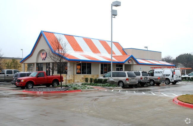
Property Record
6301 W Parmer Ln, Austin, TX 78729


Save to a Folder
{{folder.Name}}
{{folder.ListingIds.length}} Properties
{{folder.ListingIds.length}} Property
Create a New Folder
Property Detail
6301 W Parmer Ln
Austin-Round Rock-San Marcos, TX
LOT 3 BLK A MILWOOD SEC 24 AMENDED PLAT RESUB OF LTS 1-A,2-A&4-A
714849
Williamson
Restaurantdrivein
Texas
B and X Area of moderate flood hazard, usually the area between the limits of the 100-year and 500-year floods.
3
2025
0.97 AC
2025
Northwest
034100
Austin
3,234 SF
NEARBY LISTINGS FOR SALE OR LEASE
DEMOGRAPHICS near 6301 W Parmer Ln
1 mile
3 mile
5 mile
2025 Total Population
14,274
92,218
267,629
2030 Population
15,107
99,624
289,660
Pop Growth 2025-2030
+ 5.84%
+ 8.03%
+ 8.23%
Average Age
36
38
38
2025 Total Households
6,713
42,516
118,634
HH Growth 2025-2030
+ 6.14%
+ 8.63%
+ 8.65%
Median Household Inc
$95,173
$96,727
$98,332
Avg Household Size
2.10
2.10
2.20
2025 Avg HH Vehicles
2.00
2.00
2.00
Median Home Value
$447,890
$597,384
$582,100
Median Year Built
1995
1993
1996
Nearby Places
Map Layers
Map Styles
 Street
 Aerial
Layers
 Traffic
 Biking
Places
Listings with unknown addresses are not visible on the map
- Restaurants
- Banks
- Shops
- Fitness
- Groceries
PUBLIC TRANSPORTATION
AIRPORT
Austin-Bergstrom International
Drive
Walk
Distance
Austin-Bergstrom International
39 min
25.5 mi
Freight Ports
Calhoun Port
Drive
Walk
Distance
Calhoun Port
204 min
169.0 mi
Nearby Properties
Address
Land Use
TOTAL SIZE
Lot Size
Zoning
Address
Land Use
TOTAL SIZE
Lot Size
Zoning
3,601,391 SF
159.61 AC
Address
Land Use
TOTAL SIZE
Lot Size
Zoning
13,523 SF
128.82 AC
Address
Land Use
TOTAL SIZE
Lot Size
Zoning
830,637 SF
23.22 AC
Address
Land Use
TOTAL SIZE
Lot Size
Zoning
462,651 SF
81.77 AC
Address
Land Use
TOTAL SIZE
Lot Size
Zoning
750,565 SF
65.25 AC
Address
Land Use
TOTAL SIZE
Lot Size
Zoning
492,227 SF
23.59 AC
Address
Land Use
TOTAL SIZE
Lot Size
Zoning
172,307 SF
11.95 AC
Address
Land Use
TOTAL SIZE
Lot Size
Zoning
381,408 SF
22.17 AC
Address
Land Use
TOTAL SIZE
Lot Size
Zoning
1,179,402 SF
92.28 AC
Address
Land Use
TOTAL SIZE
Lot Size
Zoning
451,564 SF
25 AC
Address
Land Use
TOTAL SIZE
Lot Size
Zoning
285,120 SF
15.60 AC
Address
Land Use
TOTAL SIZE
Lot Size
Zoning
365,399 SF
11.50 AC
Address
Land Use
TOTAL SIZE
Lot Size
Zoning
277,020 SF
1.41 AC
Address
Land Use
TOTAL SIZE
Lot Size
Zoning
687,401 SF
20.47 AC
Address
Land Use
TOTAL SIZE
Lot Size
Zoning
400,536 SF
31.68 AC
Address
Land Use
TOTAL SIZE
Lot Size
Zoning
280,279 SF
10.38 AC
Address
Land Use
TOTAL SIZE
Lot Size
Zoning
331,086 SF
17.23 AC
Address
Land Use
TOTAL SIZE
Lot Size
Zoning
323,148 SF
20.57 AC
Address
Land Use
TOTAL SIZE
Lot Size
Zoning
397,968 SF
21.69 AC
Address
Land Use
TOTAL SIZE
Lot Size
Zoning
381,556 SF
21.50 AC
Address
Land Use
TOTAL SIZE
Lot Size
Zoning
303,280 SF
16.96 AC
Address
Land Use
TOTAL SIZE
Lot Size
Zoning
408,335 SF
31.16 AC
Address
Land Use
TOTAL SIZE
Lot Size
Zoning
1,152,630 SF
23.29 AC
Address
Land Use
TOTAL SIZE
Lot Size
Zoning
369,126 SF
29.50 AC
Address
Land Use
TOTAL SIZE
Lot Size
Zoning
410,378 SF
21.43 AC
Address
Land Use
TOTAL SIZE
Lot Size
Zoning
277,022 SF
14.10 AC
Address
Land Use
TOTAL SIZE
Lot Size
Zoning
288,750 SF
15.38 AC
Address
Land Use
TOTAL SIZE
Lot Size
Zoning
366,444 SF
36.29 AC
Address
Land Use
TOTAL SIZE
Lot Size
Zoning
306,387 SF
14.63 AC
Address
Land Use
TOTAL SIZE
Lot Size
Zoning
273,320 SF
10.97 AC
The World's #1 Commercial Real Estate Marketplace
Connect with us
© 2026 CoStar Group
The information above has been obtained from sources believed reliable. While we do not doubt its accuracy we have not verified it and make no guarantee, warranty or representation about it. It is your responsibility to independently confirm its accuracy and completeness. Any projections, opinions, assumptions, or estimates used are for example only and do not represent the current or future performance of the property. The value of this transaction to you depends on tax and other factors which should be evaluated by your tax, financial, and legal advisors. You and your advisors should conduct a careful, independent investigation of the property to determine to your satisfaction the suitability of the property for your needs.