Property Record
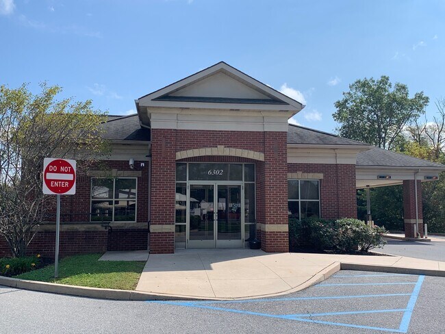
6302 Route 309, New Tripoli, PA 18066

NEARBY LISTINGS FOR SALE OR LEASE
-
-
View all New Tripoli listings for sale on LoopNet.com
Property Detail
6302 Route 309
543987340771-1
LOTS: 001
Financialbuilding
Lehigh
A
Pennsylvania
42077C0115F
1
2025
2.78 AC
2025
Lehigh Valley
005301
Philadelphia
2,609 SF
Allentown-Bethlehem-Easton, PA-NJ
DEMOGRAPHICS near 6302 Route 309
1 Mile
3 Mile
5 Mile
2024 Total Population
495
4,695
15,769
2029 Population
499
4,730
15,860
Pop Growth 2024-2029
+ 0.81%
+ 0.75%
+ 0.58%
Average Age
43
42
43
2024 Total Households
192
1,792
6,098
HH Growth 2024-2029
+ 0.52%
+ 0.73%
+ 0.52%
Median Household Inc
$98,386
$92,432
$95,496
Avg Household Size
2.60
2.60
2.60
2024 Avg HH Vehicles
3.00
2.00
2.00
Median Home Value
$321,154
$284,745
$291,792
Median Year Built
1981
1978
1980
Nearby Places
Map Layers
Map Styles
 Street
 Aerial
- Restaurants
- Banks
- Shops
- Fitness
- Groceries
PUBLIC TRANSPORTATION
AIRPORT
Lehigh Valley International
DRIVE
WALK
Distance
Lehigh Valley International
30 min
15.8 mi
Freight Ports
Port of Philadelphia
DRIVE
WALK
Distance
Port of Philadelphia
88 min
68.9 mi
SALE & LEASE HISTORY
LISTING DATE
SALE/LEASE

Jan 05, 2022
For Sale
Nearby Properties
Address
Land Use
TOTAL SIZE
Lot Size
Zoning
Address
Land Use
TOTAL SIZE
Lot Size
Zoning
185,752 SF
26.72 AC
AP
Address
Land Use
TOTAL SIZE
Lot Size
Zoning
134,861 SF
26.86 AC
AP
Address
Land Use
TOTAL SIZE
Lot Size
Zoning
62,755 SF
16.87 AC
AP
Address
Land Use
TOTAL SIZE
Lot Size
Zoning
6,553 SF
254.71 AC
AP
Address
Land Use
TOTAL SIZE
Lot Size
Zoning
4,635 SF
386.70 AC
RC
Address
Land Use
TOTAL SIZE
Lot Size
Zoning
247.20 AC
RC
Address
Land Use
TOTAL SIZE
Lot Size
Zoning
12,750 SF
3.89 AC
RV
Address
Land Use
TOTAL SIZE
Lot Size
Zoning
188 AC
RC
Address
Land Use
TOTAL SIZE
Lot Size
Zoning
15,431 SF
11 AC
AP
Address
Land Use
TOTAL SIZE
Lot Size
Zoning
11,384 SF
4.30 AC
AP
Address
Land Use
TOTAL SIZE
Lot Size
Zoning
1,612 SF
154.60 AC
RC
Address
Land Use
TOTAL SIZE
Lot Size
Zoning
7,880 SF
1 AC
RC
Address
Land Use
TOTAL SIZE
Lot Size
Zoning
8,916 SF
1.07 AC
VC
Address
Land Use
TOTAL SIZE
Lot Size
Zoning
136.79 AC
RC
Address
Land Use
TOTAL SIZE
Lot Size
Zoning
7,376 SF
3.61 AC
AP
Address
Land Use
TOTAL SIZE
Lot Size
Zoning
19,420 SF
3.10 AC
RV
Address
Land Use
TOTAL SIZE
Lot Size
Zoning
4,657 SF
0.64 AC
VC
Address
Land Use
TOTAL SIZE
Lot Size
Zoning
1,530 SF
1.15 AC
AP
Address
Land Use
TOTAL SIZE
Lot Size
Zoning
8,557 SF
3 AC
RC
Address
Land Use
TOTAL SIZE
Lot Size
Zoning
10.19 AC
AP
Address
Land Use
TOTAL SIZE
Lot Size
Zoning
100.30 AC
RC
Address
Land Use
TOTAL SIZE
Lot Size
Zoning
8,732 SF
3.16 AC
AP
Address
Land Use
TOTAL SIZE
Lot Size
Zoning
6,578 SF
0.83 AC
AP
Address
Land Use
TOTAL SIZE
Lot Size
Zoning
76.50 AC
AP
Address
Land Use
TOTAL SIZE
Lot Size
Zoning
2,544 SF
80.06 AC
AP
Address
Land Use
TOTAL SIZE
Lot Size
Zoning
97.60 AC
AP
Address
Land Use
TOTAL SIZE
Lot Size
Zoning
5,613 SF
1.11 AC
VC
Address
Land Use
TOTAL SIZE
Lot Size
Zoning
5,768 SF
71.70 AC
AP
Address
Land Use
TOTAL SIZE
Lot Size
Zoning
10,457 SF
1.83 AC
RV
The World's #1 Commercial Real Estate Marketplace
Connect with us
© 2026 CoStar Group
The information above has been obtained from sources believed reliable. While we do not doubt its accuracy we have not verified it and make no guarantee, warranty or representation about it. It is your responsibility to independently confirm its accuracy and completeness. Any projections, opinions, assumptions, or estimates used are for example only and do not represent the current or future performance of the property. The value of this transaction to you depends on tax and other factors which should be evaluated by your tax, financial, and legal advisors. You and your advisors should conduct a careful, independent investigation of the property to determine to your satisfaction the suitability of the property for your needs.