Property Record
6303 Kentucky Ave, Indianapolis, IN 46221
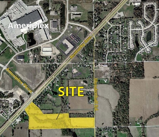


This Property Is For Sale
NEARBY LISTINGS FOR SALE OR LEASE
Property Detail
6303 Kentucky Ave
Indianapolis-Carmel-Anderson, IN
PT W1/2 NE1/4 S10 T14 R2 1019.31 N & 65 NE SW COR P.O.B. NE95 SE300 SW95 NW300 LESS HWY .47AC
49-13-10-109-002.000-200
Marion
Recreationalacreage
Indiana
X
132
18097C0220F
0.47 AC
2023
Airport
2024
Indianapolis
370304
DEMOGRAPHICS near 6303 Kentucky Ave
1 Mile
3 Mile
5 Mile
2024 Total Population
1,947
26,918
69,341
2029 Population
1,954
26,754
72,219
Pop Growth 2024-2029
+ 0.36%
(0.61%)
+ 4.15%
Average Age
38
36
37
2024 Total Households
680
9,405
25,792
HH Growth 2024-2029
+ 0.44%
(0.55%)
+ 4.95%
Median Household Inc
$84,290
$81,153
$74,227
Avg Household Size
2.70
2.80
2.60
2024 Avg HH Vehicles
2.00
2.00
2.00
Median Home Value
$249,684
$236,146
$235,100
Median Year Built
1993
1998
1993
Nearby Places
Map Layers
Map Styles
 Street
 Aerial
- Restaurants
- Banks
- Shops
- Fitness
- Groceries
PUBLIC TRANSPORTATION
AIRPORT
Indianapolis International
DRIVE
WALK
Distance
Indianapolis International
12 min
5.0 mi
Freight Ports
Port of Toledo
DRIVE
WALK
Distance
Port of Toledo
285 min
236.6 mi
Nearby Properties
Address
Land Use
TOTAL SIZE
Lot Size
Zoning
Address
Land Use
TOTAL SIZE
Lot Size
Zoning
911,062 SF
54.40 AC
ZO01
Address
Land Use
TOTAL SIZE
Lot Size
Zoning
41.50 AC
Address
Land Use
TOTAL SIZE
Lot Size
Zoning
822,500 SF
45.66 AC
Address
Land Use
TOTAL SIZE
Lot Size
Zoning
747,256 SF
41.32 AC
Address
Land Use
TOTAL SIZE
Lot Size
Zoning
665,724 SF
47.25 AC
ZO01
Address
Land Use
TOTAL SIZE
Lot Size
Zoning
798,160 SF
44.46 AC
ZO01
Address
Land Use
TOTAL SIZE
Lot Size
Zoning
997,763 SF
65.80 AC
ZO01
Address
Land Use
TOTAL SIZE
Lot Size
Zoning
292,315 SF
28.97 AC
Address
Land Use
TOTAL SIZE
Lot Size
Zoning
695,702 SF
39.68 AC
ZO03
Address
Land Use
TOTAL SIZE
Lot Size
Zoning
480,000 SF
40.60 AC
Address
Land Use
TOTAL SIZE
Lot Size
Zoning
462,275 SF
25.83 AC
ZO01
Address
Land Use
TOTAL SIZE
Lot Size
Zoning
7,028 SF
25.48 AC
ZO01
Address
Land Use
TOTAL SIZE
Lot Size
Zoning
442,201 SF
21.48 AC
Address
Land Use
TOTAL SIZE
Lot Size
Zoning
383,727 SF
25.26 AC
Address
Land Use
TOTAL SIZE
Lot Size
Zoning
423,757 SF
28.71 AC
Address
Land Use
TOTAL SIZE
Lot Size
Zoning
465,480 SF
34.07 AC
Address
Land Use
TOTAL SIZE
Lot Size
Zoning
23.17 AC
Address
Land Use
TOTAL SIZE
Lot Size
Zoning
442,215 SF
24.69 AC
Address
Land Use
TOTAL SIZE
Lot Size
Zoning
328,331 SF
39.63 AC
ZO01
Address
Land Use
TOTAL SIZE
Lot Size
Zoning
380,155 SF
17.02 AC
Address
Land Use
TOTAL SIZE
Lot Size
Zoning
3,394 SF
25.27 AC
ZO01
Address
Land Use
TOTAL SIZE
Lot Size
Zoning
340,080 SF
16.82 AC
Address
Land Use
TOTAL SIZE
Lot Size
Zoning
262,710 SF
19.50 AC
Address
Land Use
TOTAL SIZE
Lot Size
Zoning
315,000 SF
20.21 AC
Address
Land Use
TOTAL SIZE
Lot Size
Zoning
14.31 AC
Address
Land Use
TOTAL SIZE
Lot Size
Zoning
228,839 SF
27.60 AC
ZO01
Address
Land Use
TOTAL SIZE
Lot Size
Zoning
12,880 SF
42.54 AC
ZO01
Address
Land Use
TOTAL SIZE
Lot Size
Zoning
9.33 AC
Address
Land Use
TOTAL SIZE
Lot Size
Zoning
264,960 SF
16.85 AC
ZO01
Address
Land Use
TOTAL SIZE
Lot Size
Zoning
129,490 SF
27.92 AC
ZO01
The World's #1 Commercial Real Estate Marketplace
Connect with us
© 2025 CoStar Group
The information above has been obtained from sources believed reliable. While we do not doubt its accuracy we have not verified it and make no guarantee, warranty or representation about it. It is your responsibility to independently confirm its accuracy and completeness. Any projections, opinions, assumptions, or estimates used are for example only and do not represent the current or future performance of the property. The value of this transaction to you depends on tax and other factors which should be evaluated by your tax, financial, and legal advisors. You and your advisors should conduct a careful, independent investigation of the property to determine to your satisfaction the suitability of the property for your needs.