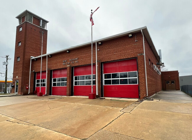
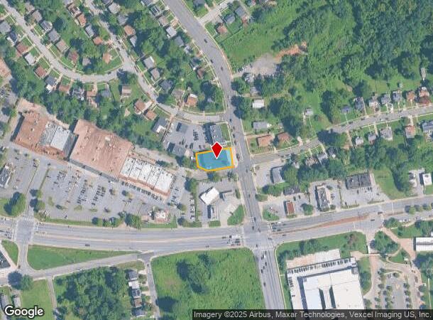
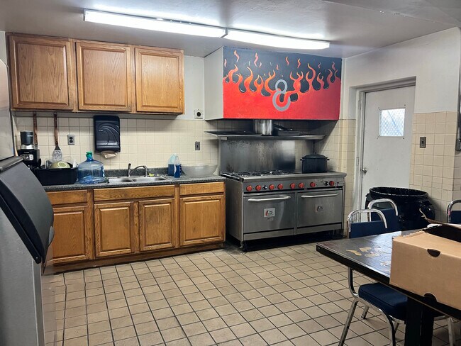
Property Record
6305 Addison Rd, Capitol Heights, MD 20743
NEARBY LISTINGS FOR SALE OR LEASE
Property Detail
6305 Addison Rd
Policefirecivildefense
Prince George's
X
Maryland
24033C0144E
0.53 AC
2024
Landover/Largo/Captl Hts
2025
Washington, DC
802901
Washington-Arlington-Alexandria, DC-VA-MD-WV
7,168 SF
18-1995786
DEMOGRAPHICS near 6305 Addison Rd
1 mile
3 mile
5 mile
2024 Total Population
15,124
155,501
411,276
2029 Population
14,635
148,765
393,430
Pop Growth 2024-2029
(3.23%)
(4.33%)
(4.34%)
Average Age
40
39
39
2024 Total Households
5,597
59,800
160,022
HH Growth 2024-2029
(3.47%)
(4.77%)
(4.89%)
Median Household Inc
$66,172
$63,710
$70,722
Avg Household Size
2.60
2.50
2.50
2024 Avg HH Vehicles
1.00
1.00
1.00
Median Home Value
$274,278
$315,164
$359,293
Median Year Built
1965
1966
1966
Nearby Places
Map Layers
Map Styles
 Street
 Aerial
Transit
 Traffic
 Biking
Places
Listings with unknown addresses are not visible on the map
- Restaurants
- Banks
- Shops
- Fitness
- Groceries
PUBLIC TRANSPORTATION
TRANSIT/SUBWAY
Addison Road-Seat Pleasant (Blue Line - Washington Metropolitan Area Transit Authority Metrorail (Metrorail), Silver Line - Washington Metropolitan Area Transit Authority Metrorail (Metrorail))
Drive
Walk
Distance
Addison Road-Seat Pleasant (Blue Line - Washington Metropolitan Area Transit Authority Metrorail (Metrorail), Silver Line - Washington Metropolitan Area Transit Authority Metrorail (Metrorail))
0 min
5 min
0.3 mi
Capitol Heights, Blue/Silver Line Center Platform (Metrorail Blue Line - WMATA, Metrorail Silver Line - WMATA)
Drive
Walk
Distance
Capitol Heights, Blue/Silver Line Center Platform (Metrorail Blue Line - WMATA, Metrorail Silver Line - WMATA)
2 min
15 min
0.8 mi
COMMUTER RAIL
New Carrollton Marc Nb (PENN - WASHINGTON - Maryland Transit Administration)
Drive
Walk
Distance
New Carrollton Marc Nb (PENN - WASHINGTON - Maryland Transit Administration)
14 min
8.4 mi
New Carrollton (PENN - WASHINGTON - Maryland Area Regional Commuter Trains (The MARC), Penn Line - Maryland Area Regional Commuter Trains (The MARC))
Drive
Walk
Distance
New Carrollton (PENN - WASHINGTON - Maryland Area Regional Commuter Trains (The MARC), Penn Line - Maryland Area Regional Commuter Trains (The MARC))
14 min
8.4 mi
AIRPORT
Ronald Reagan Washington Ntl
Drive
Walk
Distance
Ronald Reagan Washington Ntl
23 min
12.4 mi
Baltimore/Washington International Thurgood Marshall
Drive
Walk
Distance
Baltimore/Washington International Thurgood Marshall
43 min
29.2 mi
Freight Ports
Port of Baltimore
Drive
Walk
Distance
Port of Baltimore
53 min
35.8 mi
SALE & LEASE HISTORY
LISTING DATE
SALE/LEASE

Feb 02, 2023
For Sale
Nearby Properties
Address
Land Use
TOTAL SIZE
Lot Size
Zoning
Address
Land Use
TOTAL SIZE
Lot Size
Zoning
35.03 AC
LTOE
Address
Land Use
TOTAL SIZE
Lot Size
Zoning
236,535 SF
12.54 AC
R-2
Address
Land Use
TOTAL SIZE
Lot Size
Zoning
177,081 SF
23.22 AC
LCD
Address
Land Use
TOTAL SIZE
Lot Size
Zoning
241,725 SF
4.71 AC
MU-7B;PDR-
Address
Land Use
TOTAL SIZE
Lot Size
Zoning
62.03 AC
UNZONED
Address
Land Use
TOTAL SIZE
Lot Size
Zoning
229,238 SF
1.51 AC
MU-7B
Address
Land Use
TOTAL SIZE
Lot Size
Zoning
12.60 AC
LTOC
Address
Land Use
TOTAL SIZE
Lot Size
Zoning
821,240 SF
48.32 AC
IH
Address
Land Use
TOTAL SIZE
Lot Size
Zoning
192,440 SF
7.67 AC
R-2;RA-1
Address
Land Use
TOTAL SIZE
Lot Size
Zoning
107,130 SF
2.98 AC
R-2;RA-1
Address
Land Use
TOTAL SIZE
Lot Size
Zoning
419,689 SF
66.84 AC
PDR-1;PDR-
Address
Land Use
TOTAL SIZE
Lot Size
Zoning
132,000 SF
RA-1
Address
Land Use
TOTAL SIZE
Lot Size
Zoning
262,236 SF
15.26 AC
MU-8B
Address
Land Use
TOTAL SIZE
Lot Size
Zoning
379,168 SF
18.94 AC
RMF20
Address
Land Use
TOTAL SIZE
Lot Size
Zoning
181,530 SF
4.72 AC
R-2
Address
Land Use
TOTAL SIZE
Lot Size
Zoning
262 SF
24.86 AC
RMF20
Address
Land Use
TOTAL SIZE
Lot Size
Zoning
10.63 AC
RMF20
Address
Land Use
TOTAL SIZE
Lot Size
Zoning
123,950 SF
4.65 AC
R-2
Address
Land Use
TOTAL SIZE
Lot Size
Zoning
386,326 SF
62.74 AC
IE
Address
Land Use
TOTAL SIZE
Lot Size
Zoning
206,118 SF
0.82 AC
RA-1
Address
Land Use
TOTAL SIZE
Lot Size
Zoning
99,269 SF
4.73 AC
RA-1
Address
Land Use
TOTAL SIZE
Lot Size
Zoning
142,636 SF
3.69 AC
RA-1
Address
Land Use
TOTAL SIZE
Lot Size
Zoning
115,788 SF
1.77 AC
MU-4;RA-1
Address
Land Use
TOTAL SIZE
Lot Size
Zoning
162,221 SF
1.12 AC
R-2
Address
Land Use
TOTAL SIZE
Lot Size
Zoning
67,763 SF
1.66 AC
R-2
Address
Land Use
TOTAL SIZE
Lot Size
Zoning
17.90 AC
RMF20
Address
Land Use
TOTAL SIZE
Lot Size
Zoning
63,000 SF
5.60 AC
RA-1
Address
Land Use
TOTAL SIZE
Lot Size
Zoning
17.08 AC
RMF20
Address
Land Use
TOTAL SIZE
Lot Size
Zoning
245,767 SF
13.88 AC
CGO
Address
Land Use
TOTAL SIZE
Lot Size
Zoning
5.58 AC
CGO
The World's #1 Commercial Real Estate Marketplace
Connect with us
© 2026 CoStar Group
The information above has been obtained from sources believed reliable. While we do not doubt its accuracy we have not verified it and make no guarantee, warranty or representation about it. It is your responsibility to independently confirm its accuracy and completeness. Any projections, opinions, assumptions, or estimates used are for example only and do not represent the current or future performance of the property. The value of this transaction to you depends on tax and other factors which should be evaluated by your tax, financial, and legal advisors. You and your advisors should conduct a careful, independent investigation of the property to determine to your satisfaction the suitability of the property for your needs.