Property Record
6305 W 190Th St, Jordan, MN 55352
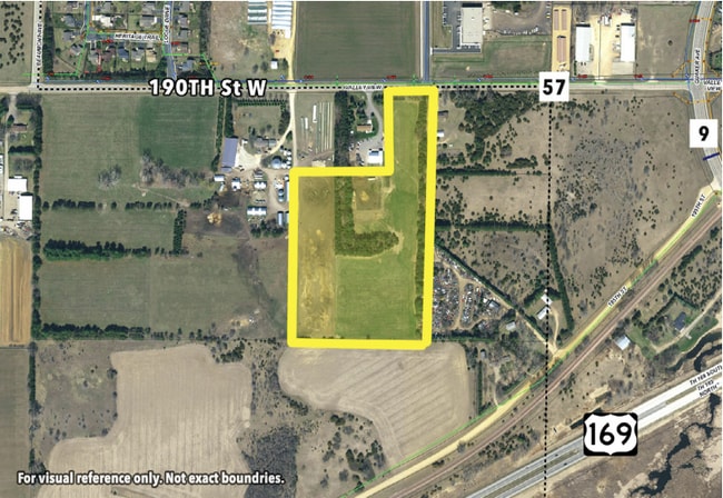
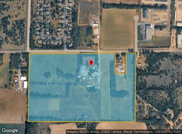
This Property Is For Sale
NEARBY LISTINGS FOR SALE OR LEASE
-
-
View all Jordan listings for sale on LoopNet.com
Property Detail
6305 W 190Th St
Minneapolis/St Paul
Scott
Minneapolis-St. Paul-Bloomington, MN-WI
Minnesota
10-924-017-0
56.86 AC
Ruralagriculturalresidence
Scott County Outlying
1,376 SF
DEMOGRAPHICS near 6305 W 190Th St
1 Mile
3 Mile
5 Mile
2024 Total Population
3,762
8,874
10,649
2029 Population
3,878
9,216
11,031
Pop Growth 2024-2029
+ 3.08%
+ 3.85%
+ 3.59%
Average Age
38
38
39
2024 Total Households
1,343
3,061
3,707
HH Growth 2024-2029
+ 3.20%
+ 3.85%
+ 3.59%
Median Household Inc
$88,830
$101,546
$103,068
Avg Household Size
2.80
2.90
2.80
2024 Avg HH Vehicles
2.00
2.00
2.00
Median Home Value
$295,747
$376,138
$401,140
Median Year Built
1992
1995
1994
Nearby Places
- Restaurants
- Banks
- Shops
- Fitness
- Groceries
PUBLIC TRANSPORTATION
AIRPORT
Minneapolis-St Paul International/Wold-Chamberlain
DRIVE
WALK
Distance
Minneapolis-St Paul International/Wold-Chamberlain
46 min
33.0 mi
Freight Ports
Port Milwaukee
DRIVE
WALK
Distance
Port Milwaukee
413 min
366.6 mi
Nearby Properties
Address
Land Use
TOTAL SIZE
Lot Size
Zoning
Address
Land Use
TOTAL SIZE
Lot Size
Zoning
25.03 AC
Address
Land Use
TOTAL SIZE
Lot Size
Zoning
58.30 AC
Address
Land Use
TOTAL SIZE
Lot Size
Zoning
2.84 AC
Address
Land Use
TOTAL SIZE
Lot Size
Zoning
2,846 SF
57.58 AC
Address
Land Use
TOTAL SIZE
Lot Size
Zoning
44,602 SF
3.02 AC
Address
Land Use
TOTAL SIZE
Lot Size
Zoning
88,216 SF
28.84 AC
Address
Land Use
TOTAL SIZE
Lot Size
Zoning
72,332 SF
3.87 AC
Address
Land Use
TOTAL SIZE
Lot Size
Zoning
6,195 SF
6.67 AC
Address
Land Use
TOTAL SIZE
Lot Size
Zoning
83,378 SF
2.84 AC
Address
Land Use
TOTAL SIZE
Lot Size
Zoning
70,696 SF
9.08 AC
Address
Land Use
TOTAL SIZE
Lot Size
Zoning
2,610 SF
365.40 AC
Address
Land Use
TOTAL SIZE
Lot Size
Zoning
12,629 SF
0.96 AC
Address
Land Use
TOTAL SIZE
Lot Size
Zoning
42,912 SF
2.84 AC
Address
Land Use
TOTAL SIZE
Lot Size
Zoning
38,045 SF
16.89 AC
Address
Land Use
TOTAL SIZE
Lot Size
Zoning
19,798 SF
9.56 AC
UBR
Address
Land Use
TOTAL SIZE
Lot Size
Zoning
54,525 SF
6.05 AC
Address
Land Use
TOTAL SIZE
Lot Size
Zoning
20.20 AC
Address
Land Use
TOTAL SIZE
Lot Size
Zoning
66,228 SF
11.27 AC
Address
Land Use
TOTAL SIZE
Lot Size
Zoning
10,572 SF
72.12 AC
UER
Address
Land Use
TOTAL SIZE
Lot Size
Zoning
25,272 SF
69 AC
Address
Land Use
TOTAL SIZE
Lot Size
Zoning
13,784 SF
1.91 AC
Address
Land Use
TOTAL SIZE
Lot Size
Zoning
Address
Land Use
TOTAL SIZE
Lot Size
Zoning
29,383 SF
9.08 AC
Address
Land Use
TOTAL SIZE
Lot Size
Zoning
37,981 SF
11.36 AC
UBR
Address
Land Use
TOTAL SIZE
Lot Size
Zoning
55,073 SF
2.61 AC
Address
Land Use
TOTAL SIZE
Lot Size
Zoning
22,352 SF
1.23 AC
Address
Land Use
TOTAL SIZE
Lot Size
Zoning
10,824 SF
1.30 AC
Address
Land Use
TOTAL SIZE
Lot Size
Zoning
Address
Land Use
TOTAL SIZE
Lot Size
Zoning
6,962 SF
1.68 AC
Address
Land Use
TOTAL SIZE
Lot Size
Zoning
19,880 SF
0.48 AC
The World's #1 Commercial Real Estate Marketplace
Connect with us
© 2025 CoStar Group
The information above has been obtained from sources believed reliable. While we do not doubt its accuracy we have not verified it and make no guarantee, warranty or representation about it. It is your responsibility to independently confirm its accuracy and completeness. Any projections, opinions, assumptions, or estimates used are for example only and do not represent the current or future performance of the property. The value of this transaction to you depends on tax and other factors which should be evaluated by your tax, financial, and legal advisors. You and your advisors should conduct a careful, independent investigation of the property to determine to your satisfaction the suitability of the property for your needs.