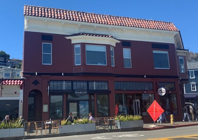
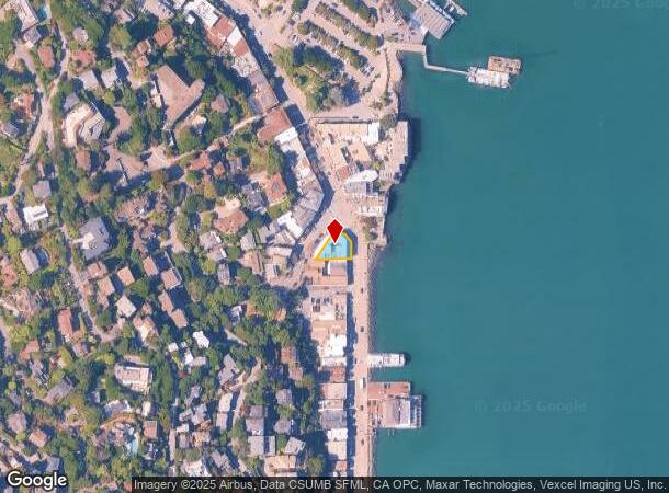
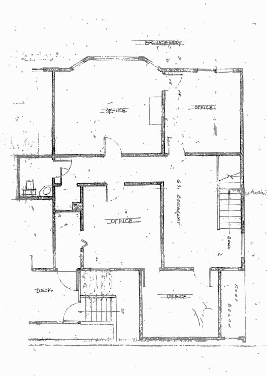
Property Record
639 Bridgeway, Sausalito, CA 94965

Current Lease Availabilities
NEARBY LISTINGS FOR SALE OR LEASE
Property Detail
639 Bridgeway
065-132-01
Sausalito Land & Ferry Co
Commercialnec
Marin
X
California
06041C0526E
8-10
2025
0.10 AC
2025
Corte Madera/Mill Valley
130201
North Bay/Santa Rosa
8,931 SF
San Rafael, CA
DEMOGRAPHICS near 639 Bridgeway
1 Mile
3 Mile
5 Mile
2024 Total Population
5,327
22,032
115,711
2029 Population
5,222
21,549
109,994
Pop Growth 2024-2029
(1.97%)
(2.19%)
(4.94%)
Average Age
52
48
44
2024 Total Households
2,905
10,434
53,934
HH Growth 2024-2029
(2.00%)
(2.30%)
(5.36%)
Median Household Inc
$145,186
$143,695
$170,693
Avg Household Size
1.80
2.10
2.10
2024 Avg HH Vehicles
2.00
2.00
1.00
Median Home Value
$1,140,852
$1,128,491
$1,129,939
Median Year Built
1953
1966
1954
Nearby Places
Map Layers
Map Styles
 Street
 Aerial
- Restaurants
- Banks
- Shops
- Fitness
- Groceries
PUBLIC TRANSPORTATION
COMMUTER RAIL
DRIVE
WALK
Distance
14 min
7.7 mi
San Francisco 4th & King (Caltrain - Caltrain (Caltrain))
DRIVE
WALK
Distance
San Francisco 4th & King (Caltrain - Caltrain (Caltrain))
23 min
9.9 mi
AIRPORT
San Francisco International
DRIVE
WALK
Distance
San Francisco International
40 min
21.9 mi
Metro Oakland International
DRIVE
WALK
Distance
Metro Oakland International
49 min
27.9 mi
Freight Ports
Port of San Francisco
DRIVE
WALK
Distance
Port of San Francisco
20 min
9.0 mi
Nearby Properties
Address
Land Use
TOTAL SIZE
Lot Size
Zoning
Address
Land Use
TOTAL SIZE
Lot Size
Zoning
64,780 SF
50 AC
Address
Land Use
TOTAL SIZE
Lot Size
Zoning
115,264 SF
6.29 AC
Address
Land Use
TOTAL SIZE
Lot Size
Zoning
175,913 SF
19.81 AC
Address
Land Use
TOTAL SIZE
Lot Size
Zoning
100,000 SF
6.30 AC
Address
Land Use
TOTAL SIZE
Lot Size
Zoning
65,933 SF
3.11 AC
Address
Land Use
TOTAL SIZE
Lot Size
Zoning
54,424 SF
2.31 AC
Address
Land Use
TOTAL SIZE
Lot Size
Zoning
159,300 SF
23.62 AC
Address
Land Use
TOTAL SIZE
Lot Size
Zoning
83,323 SF
7.58 AC
Address
Land Use
TOTAL SIZE
Lot Size
Zoning
72,126 SF
4.36 AC
Address
Land Use
TOTAL SIZE
Lot Size
Zoning
85,883 SF
3.52 AC
Address
Land Use
TOTAL SIZE
Lot Size
Zoning
79,070 SF
3.85 AC
Address
Land Use
TOTAL SIZE
Lot Size
Zoning
31,645 SF
0.61 AC
Address
Land Use
TOTAL SIZE
Lot Size
Zoning
25,517 SF
13.29 AC
Address
Land Use
TOTAL SIZE
Lot Size
Zoning
19,363 SF
2.83 AC
Address
Land Use
TOTAL SIZE
Lot Size
Zoning
66,197 SF
3.60 AC
Address
Land Use
TOTAL SIZE
Lot Size
Zoning
31,084 SF
8.07 AC
Address
Land Use
TOTAL SIZE
Lot Size
Zoning
3.53 AC
Address
Land Use
TOTAL SIZE
Lot Size
Zoning
20,352 SF
0.63 AC
Address
Land Use
TOTAL SIZE
Lot Size
Zoning
33,332 SF
1.29 AC
Address
Land Use
TOTAL SIZE
Lot Size
Zoning
Address
Land Use
TOTAL SIZE
Lot Size
Zoning
29,392 SF
0.45 AC
Address
Land Use
TOTAL SIZE
Lot Size
Zoning
15,166 SF
0.63 AC
Address
Land Use
TOTAL SIZE
Lot Size
Zoning
1.05 AC
Address
Land Use
TOTAL SIZE
Lot Size
Zoning
43,227 SF
1 AC
Address
Land Use
TOTAL SIZE
Lot Size
Zoning
103,284 SF
1.90 AC
Address
Land Use
TOTAL SIZE
Lot Size
Zoning
Address
Land Use
TOTAL SIZE
Lot Size
Zoning
2.72 AC
Address
Land Use
TOTAL SIZE
Lot Size
Zoning
Address
Land Use
TOTAL SIZE
Lot Size
Zoning
13,125 SF
0.28 AC
Address
Land Use
TOTAL SIZE
Lot Size
Zoning
1.96 AC
The World's #1 Commercial Real Estate Marketplace
Connect with us
© 2026 CoStar Group
The information above has been obtained from sources believed reliable. While we do not doubt its accuracy we have not verified it and make no guarantee, warranty or representation about it. It is your responsibility to independently confirm its accuracy and completeness. Any projections, opinions, assumptions, or estimates used are for example only and do not represent the current or future performance of the property. The value of this transaction to you depends on tax and other factors which should be evaluated by your tax, financial, and legal advisors. You and your advisors should conduct a careful, independent investigation of the property to determine to your satisfaction the suitability of the property for your needs.