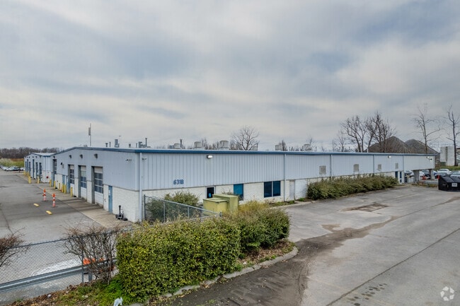
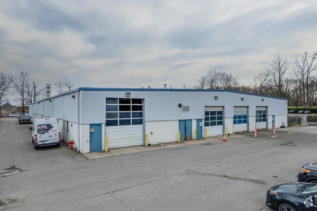
Property Record
631 Burnett Rd, Old Hickory, TN 37138

NEARBY LISTINGS FOR SALE OR LEASE
Property Detail
631 Burnett Rd
035-00-0-011
N OF SWINGING BRIDGE RD W SIDE BURNETT RD
Officebuilding
Davidson
X
Tennessee
47037C0143H
57.17 AC
2025
North
2025
Nashville
010501
Nashville-Davidson--Murfreesboro--Franklin, TN
36,231 SF
DEMOGRAPHICS near 631 Burnett Rd
1 Mile
3 Mile
5 Mile
2024 Total Population
1,012
46,406
119,557
2029 Population
1,062
47,338
124,418
Pop Growth 2024-2029
+ 4.94%
+ 2.01%
+ 4.07%
Average Age
44
40
41
2024 Total Households
452
19,712
49,138
HH Growth 2024-2029
+ 4.65%
+ 1.83%
+ 3.75%
Median Household Inc
$51,983
$57,012
$64,291
Avg Household Size
2.10
2.30
2.40
2024 Avg HH Vehicles
2.00
2.00
2.00
Median Home Value
$175,509
$263,573
$302,561
Median Year Built
2003
1981
1983
Nearby Places
Map Layers
Map Styles
 Street
 Aerial
- Restaurants
- Banks
- Shops
- Fitness
- Groceries
PUBLIC TRANSPORTATION
COMMUTER RAIL
Hermitage (East Corridor Line - Tennessee Regional Transportation Authority Music City Star (Music City Star))
DRIVE
WALK
Distance
Hermitage (East Corridor Line - Tennessee Regional Transportation Authority Music City Star (Music City Star))
18 min
8.9 mi
AIRPORT
Nashville International
DRIVE
WALK
Distance
Nashville International
27 min
14.6 mi
Nearby Properties
Address
Land Use
TOTAL SIZE
Lot Size
Zoning
Address
Land Use
TOTAL SIZE
Lot Size
Zoning
26,434 SF
12.86 AC
RM20
Address
Land Use
TOTAL SIZE
Lot Size
Zoning
102,738 SF
6.25 AC
MULTIZONE
Address
Land Use
TOTAL SIZE
Lot Size
Zoning
11,088 SF
21.28 AC
RS7.5
Address
Land Use
TOTAL SIZE
Lot Size
Zoning
30,534 SF
19.77 AC
SP
Address
Land Use
TOTAL SIZE
Lot Size
Zoning
102,431 SF
19.59 AC
6ZZ
Address
Land Use
TOTAL SIZE
Lot Size
Zoning
336,784 SF
41.54 AC
IR
Address
Land Use
TOTAL SIZE
Lot Size
Zoning
16,770 SF
76.79 AC
RM4
Address
Land Use
TOTAL SIZE
Lot Size
Zoning
17,214 SF
40.52 AC
RM9
Address
Land Use
TOTAL SIZE
Lot Size
Zoning
169,292 SF
12 AC
RM20
Address
Land Use
TOTAL SIZE
Lot Size
Zoning
25,212 SF
31.56 AC
Address
Land Use
TOTAL SIZE
Lot Size
Zoning
42,840 SF
21.43 AC
CS
Address
Land Use
TOTAL SIZE
Lot Size
Zoning
3,312 SF
33.03 AC
IR
Address
Land Use
TOTAL SIZE
Lot Size
Zoning
12,576 SF
16.09 AC
6ZZ
Address
Land Use
TOTAL SIZE
Lot Size
Zoning
191,733 SF
62.90 AC
MULTI-ZONE
Address
Land Use
TOTAL SIZE
Lot Size
Zoning
34,752 SF
19.09 AC
CS
Address
Land Use
TOTAL SIZE
Lot Size
Zoning
93,000 SF
16.44 AC
IR
Address
Land Use
TOTAL SIZE
Lot Size
Zoning
112,056 SF
40.15 AC
MULTIZONE
Address
Land Use
TOTAL SIZE
Lot Size
Zoning
3,864 SF
4.05 AC
RS5
Address
Land Use
TOTAL SIZE
Lot Size
Zoning
17,500 SF
17.56 AC
SCR
Address
Land Use
TOTAL SIZE
Lot Size
Zoning
10,336 SF
17.70 AC
6ZZ
Address
Land Use
TOTAL SIZE
Lot Size
Zoning
31,919 SF
14.69 AC
Address
Land Use
TOTAL SIZE
Lot Size
Zoning
25,200 SF
20.36 AC
RM2
Address
Land Use
TOTAL SIZE
Lot Size
Zoning
68,131 SF
4.16 AC
MUL
Address
Land Use
TOTAL SIZE
Lot Size
Zoning
22,850 SF
1.91 AC
R10
Address
Land Use
TOTAL SIZE
Lot Size
Zoning
93,232 SF
5.40 AC
RM20
Address
Land Use
TOTAL SIZE
Lot Size
Zoning
29,428 SF
6.56 AC
MULTI-ZONE
Address
Land Use
TOTAL SIZE
Lot Size
Zoning
15,456 SF
23.18 AC
Address
Land Use
TOTAL SIZE
Lot Size
Zoning
20,896 SF
17.79 AC
Address
Land Use
TOTAL SIZE
Lot Size
Zoning
106,565 SF
14.35 AC
CS
The World's #1 Commercial Real Estate Marketplace
Connect with us
© 2025 CoStar Group
The information above has been obtained from sources believed reliable. While we do not doubt its accuracy we have not verified it and make no guarantee, warranty or representation about it. It is your responsibility to independently confirm its accuracy and completeness. Any projections, opinions, assumptions, or estimates used are for example only and do not represent the current or future performance of the property. The value of this transaction to you depends on tax and other factors which should be evaluated by your tax, financial, and legal advisors. You and your advisors should conduct a careful, independent investigation of the property to determine to your satisfaction the suitability of the property for your needs.